Bears, Horses, Heat – 7/17/2017

Golder Dome disappearing as a storm rolls north. July 2017.

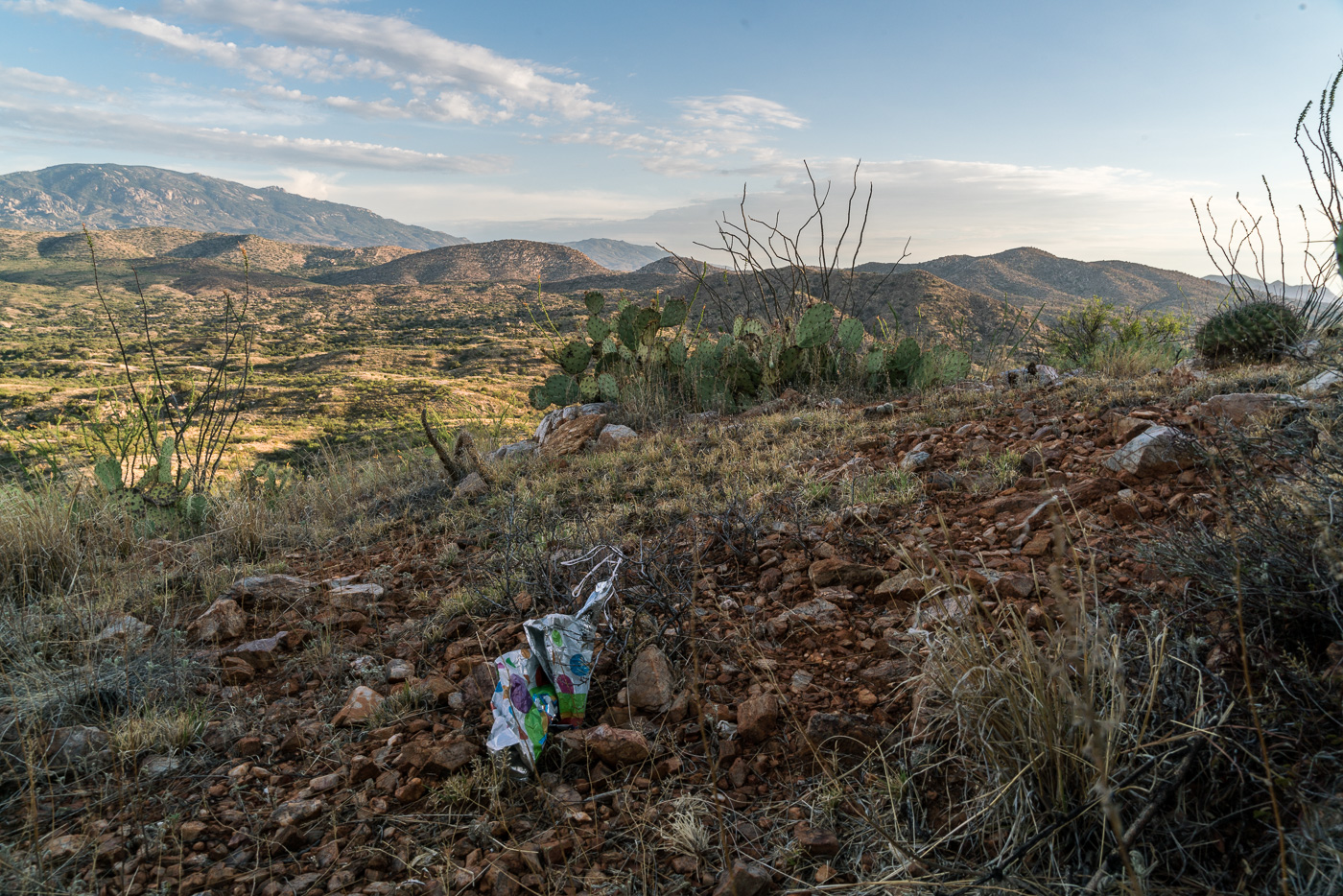
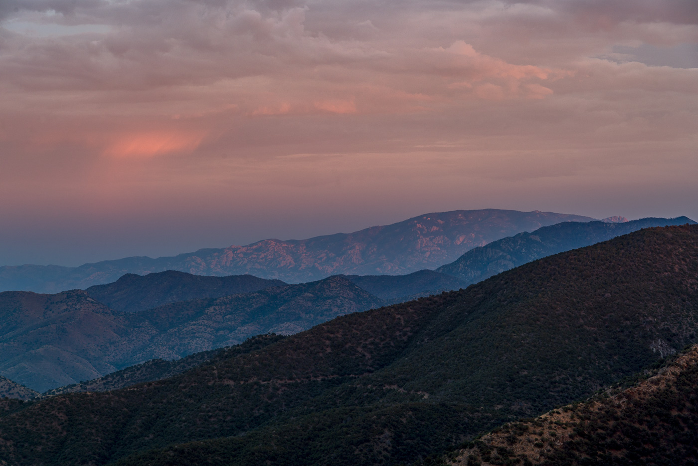
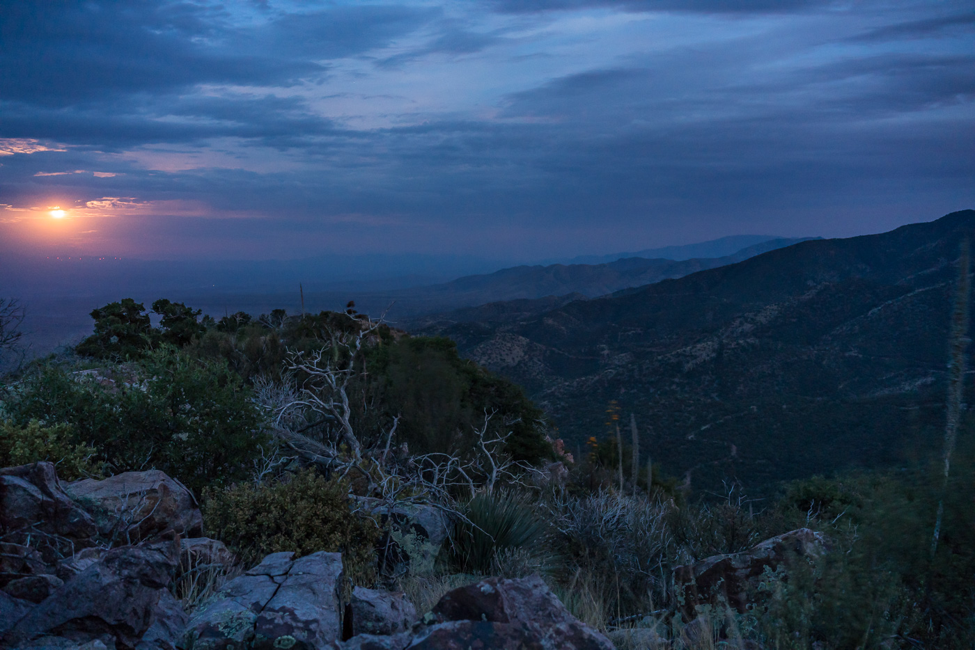
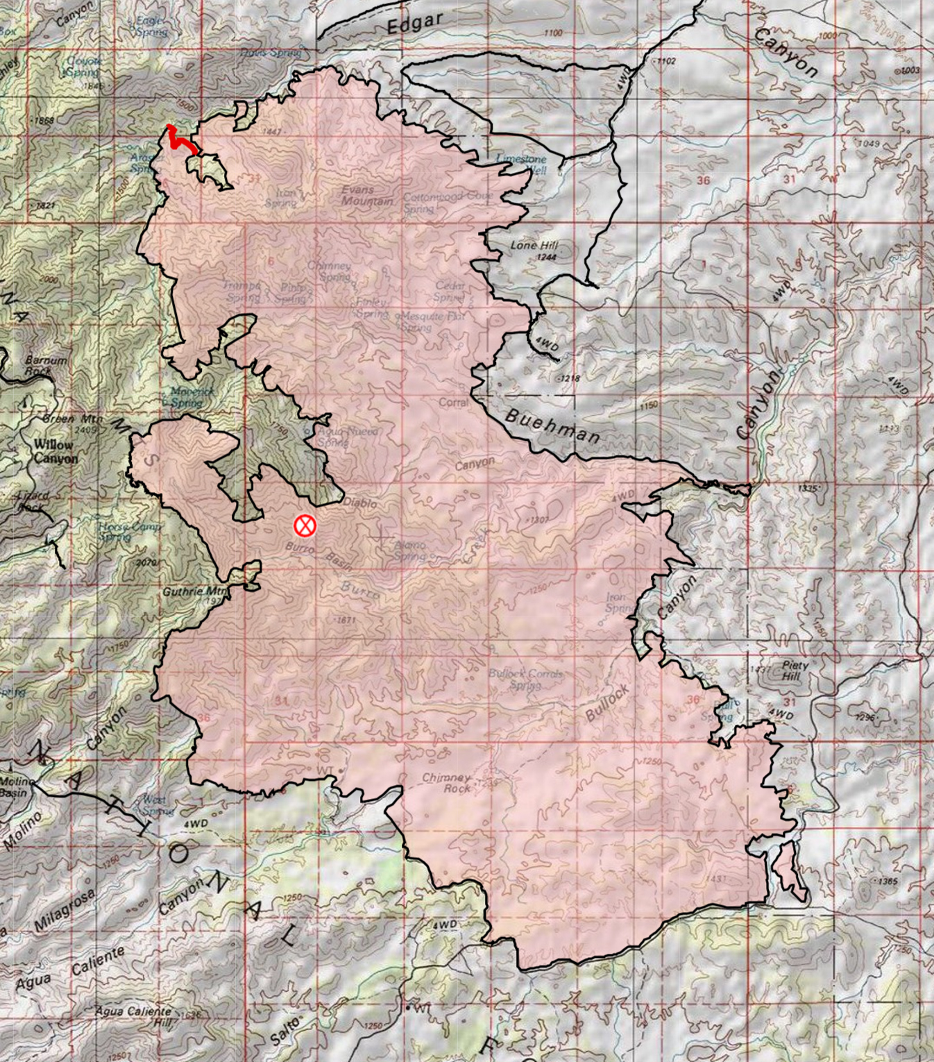
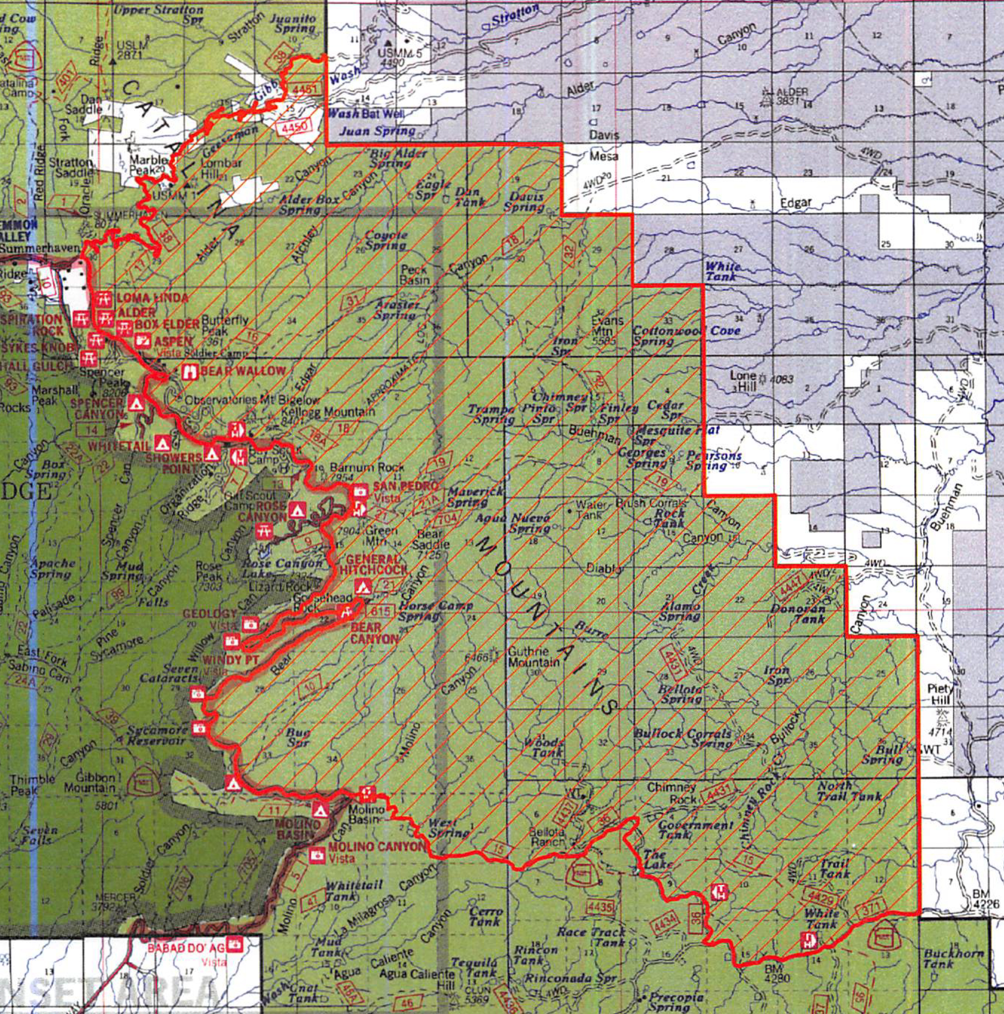
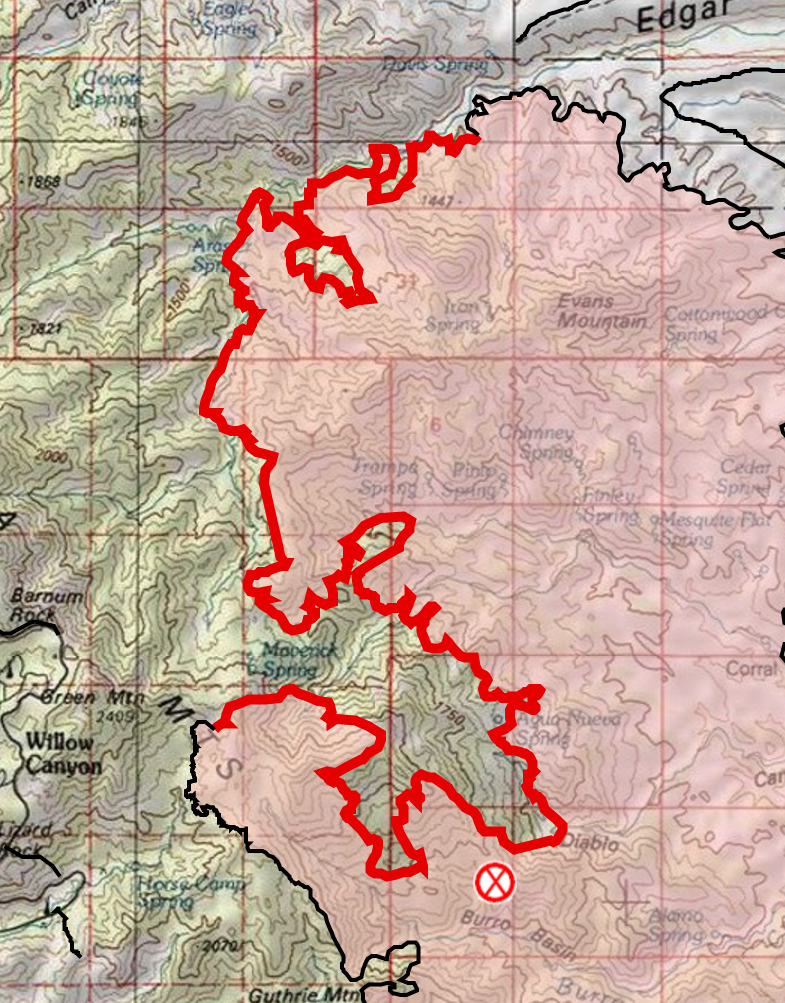
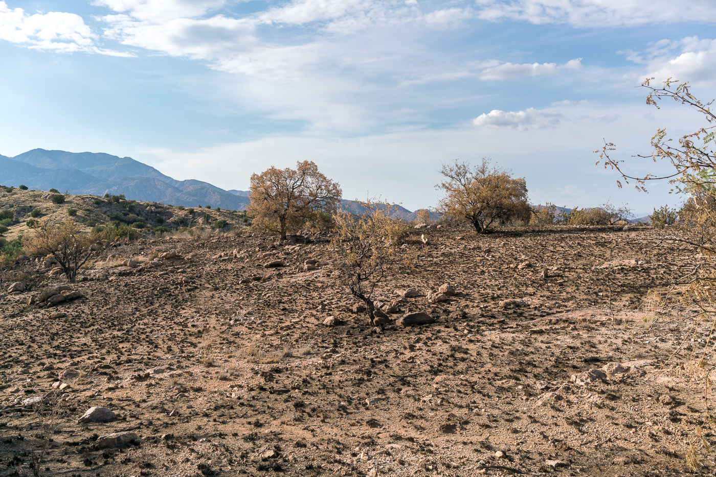
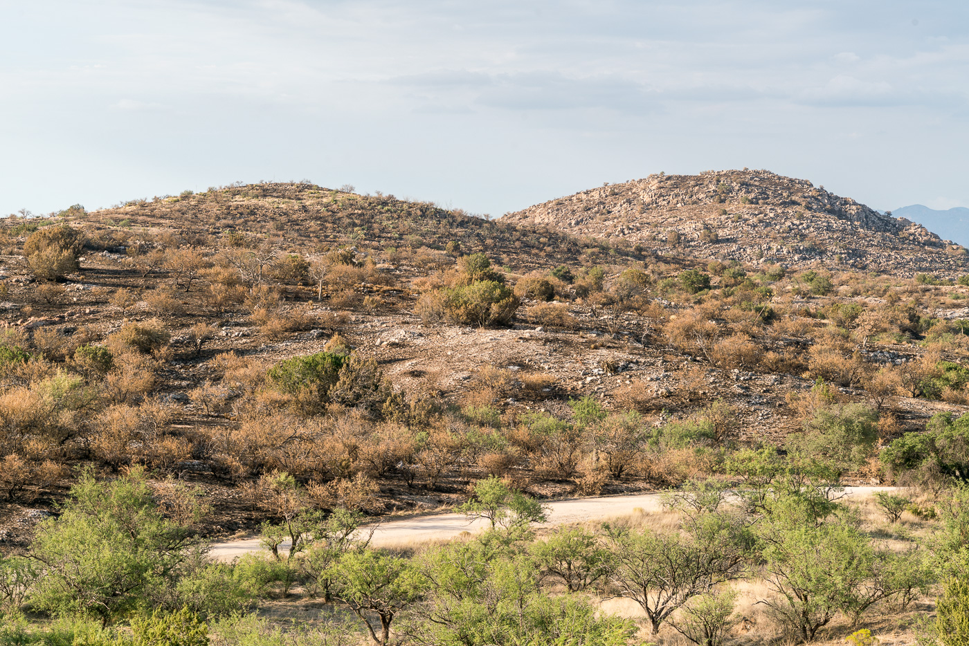
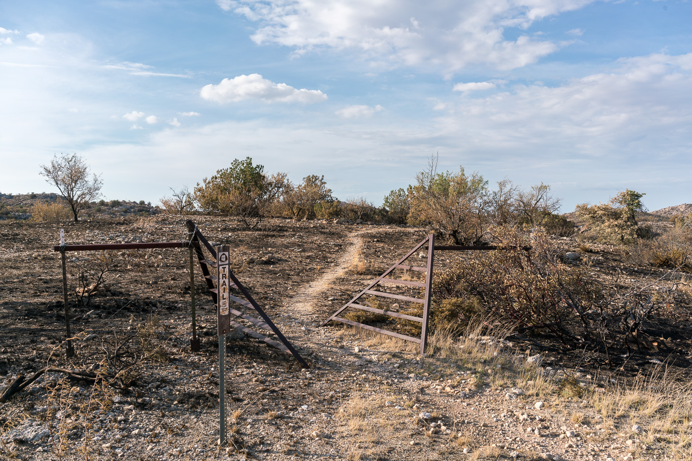
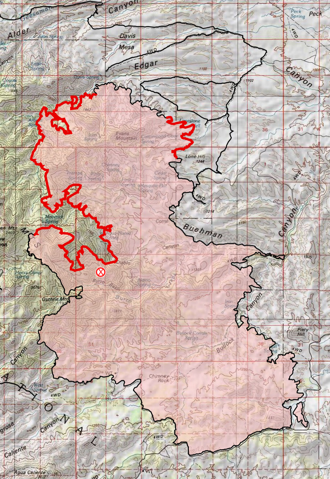
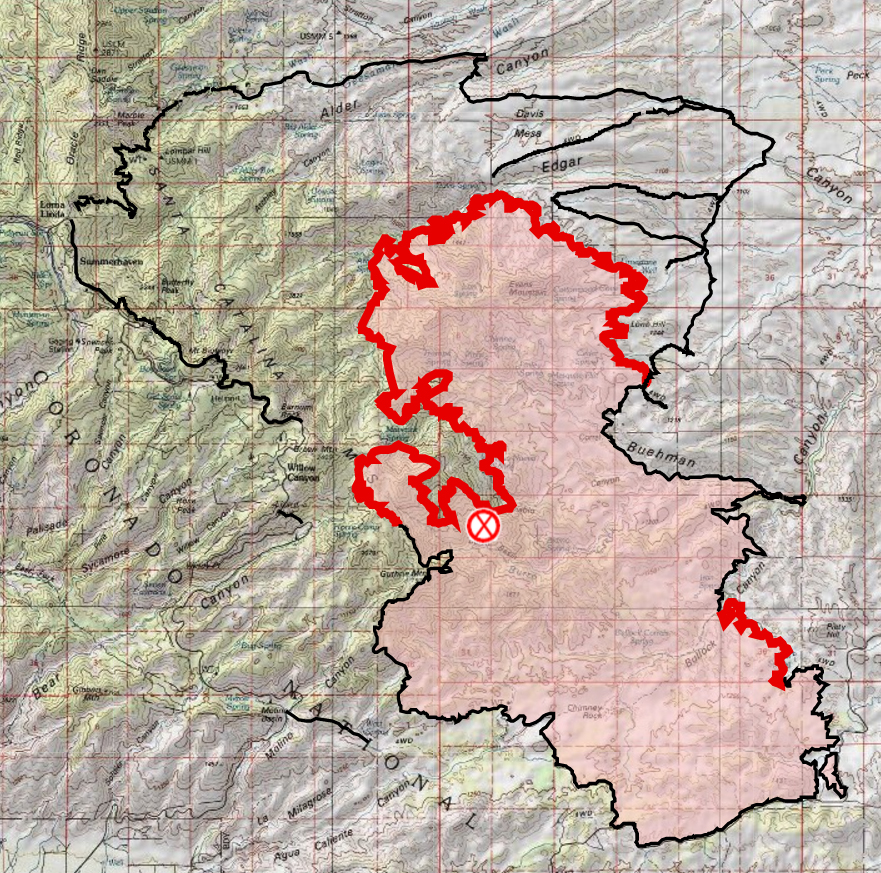
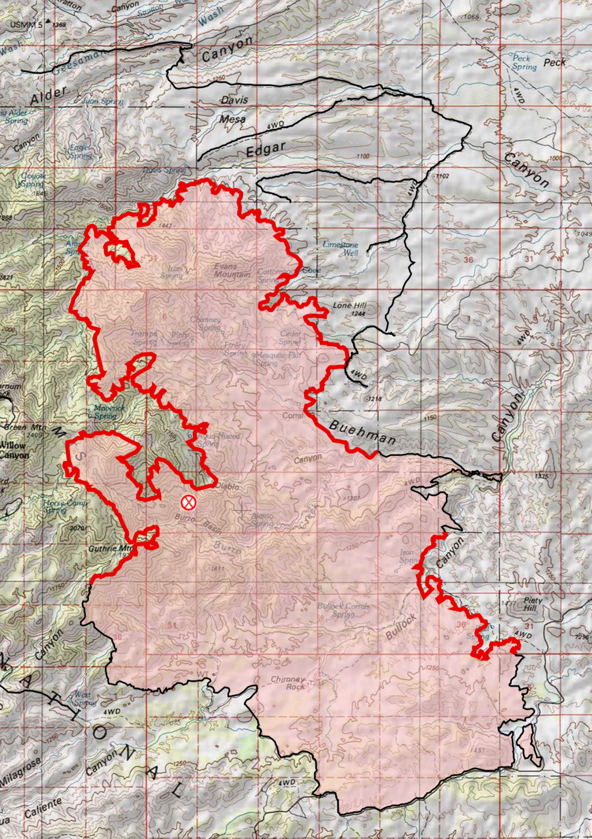
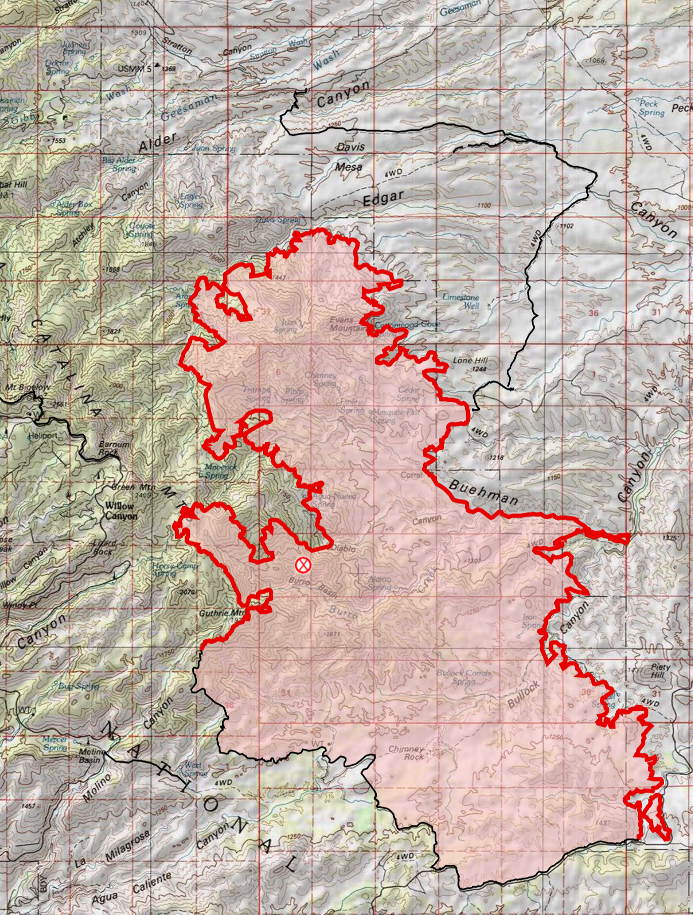
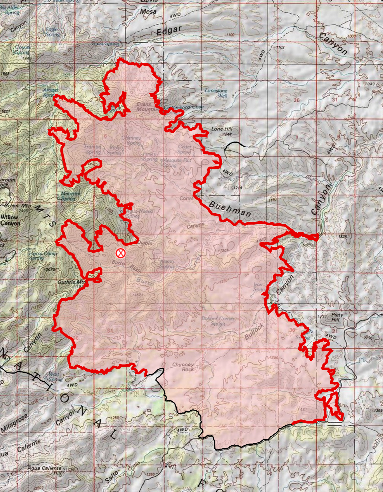
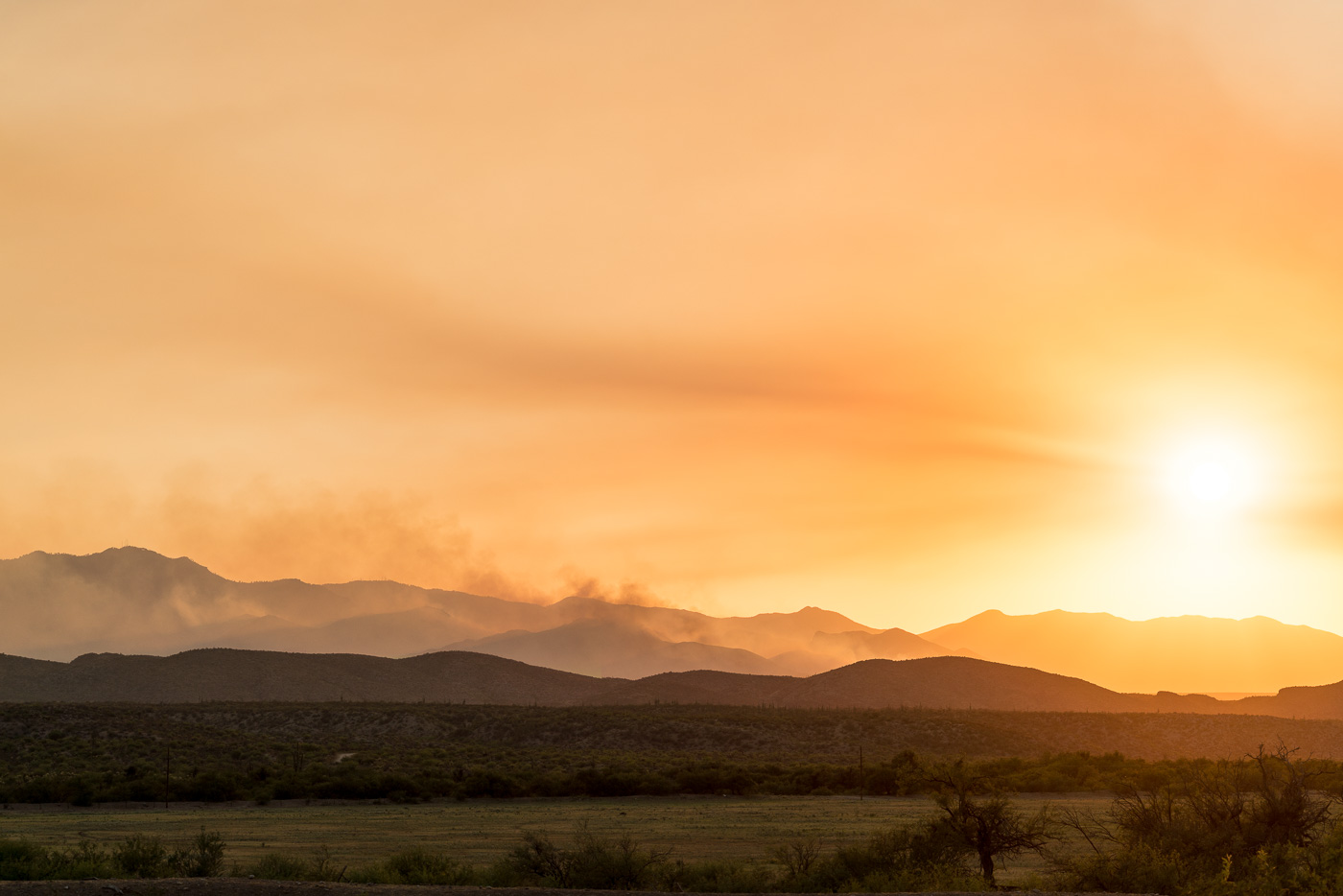
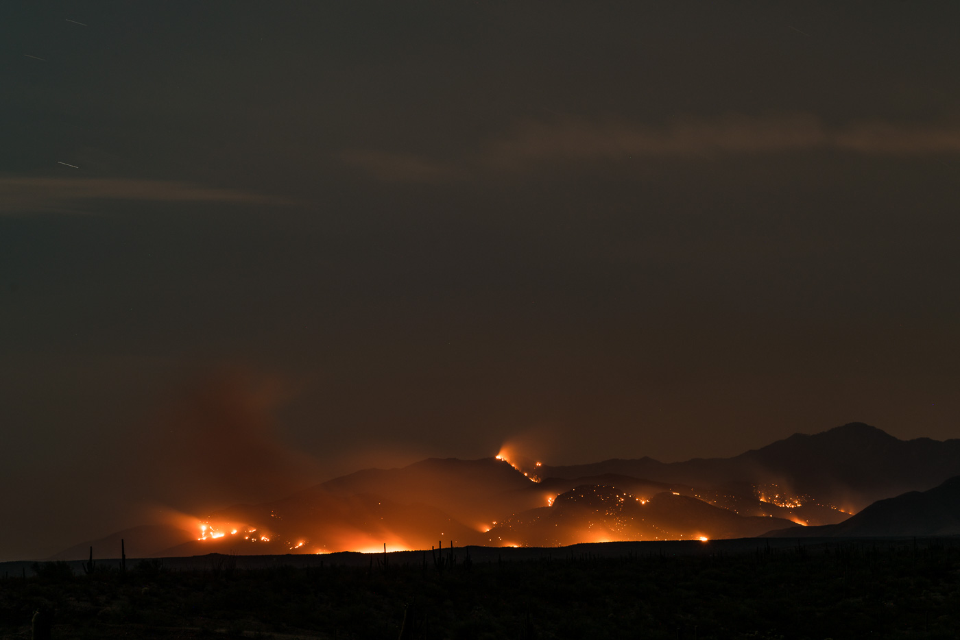
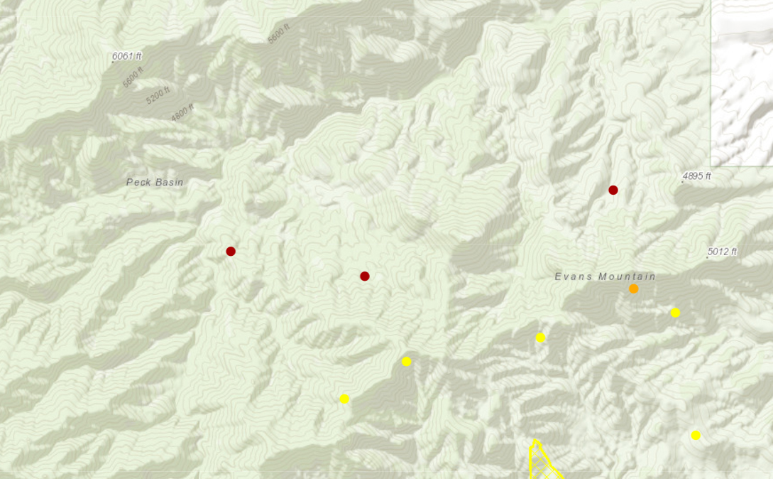
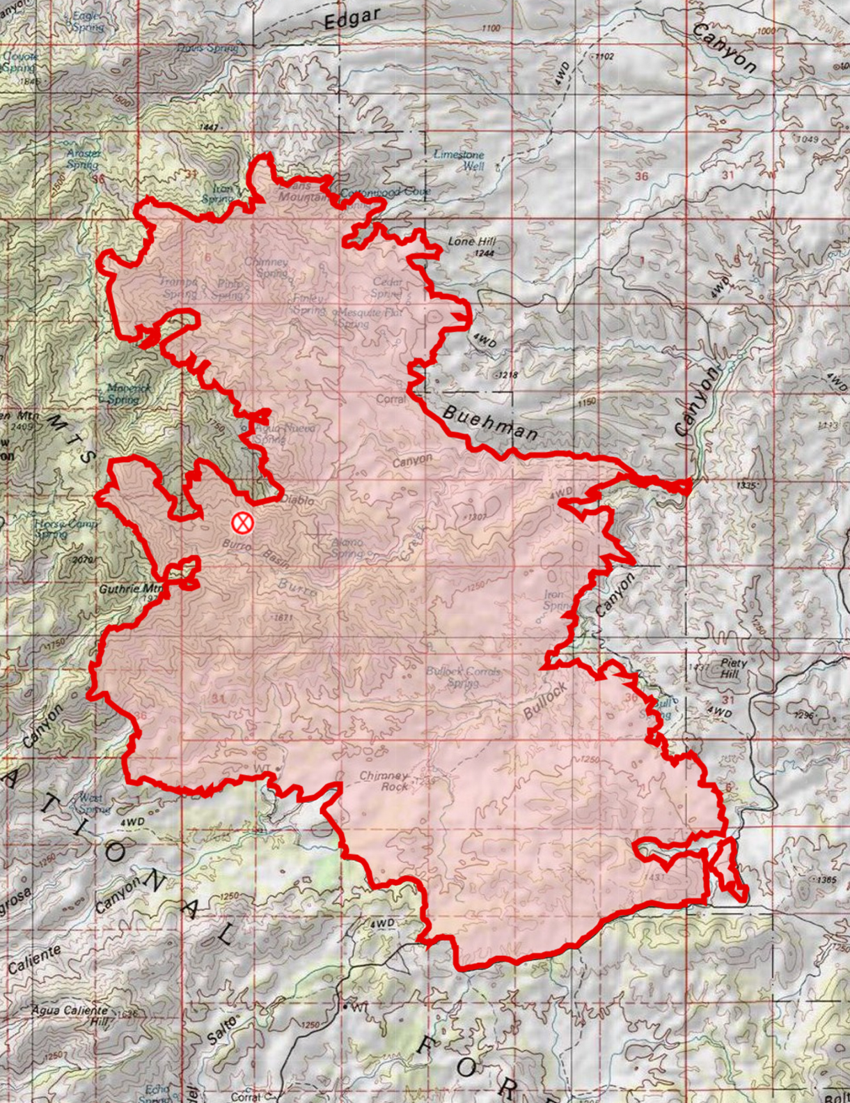
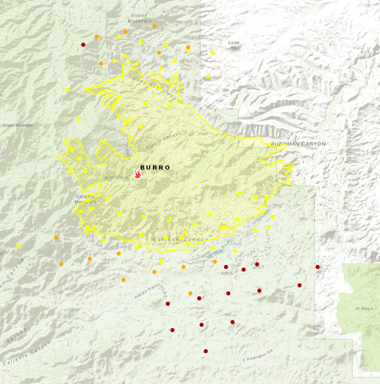
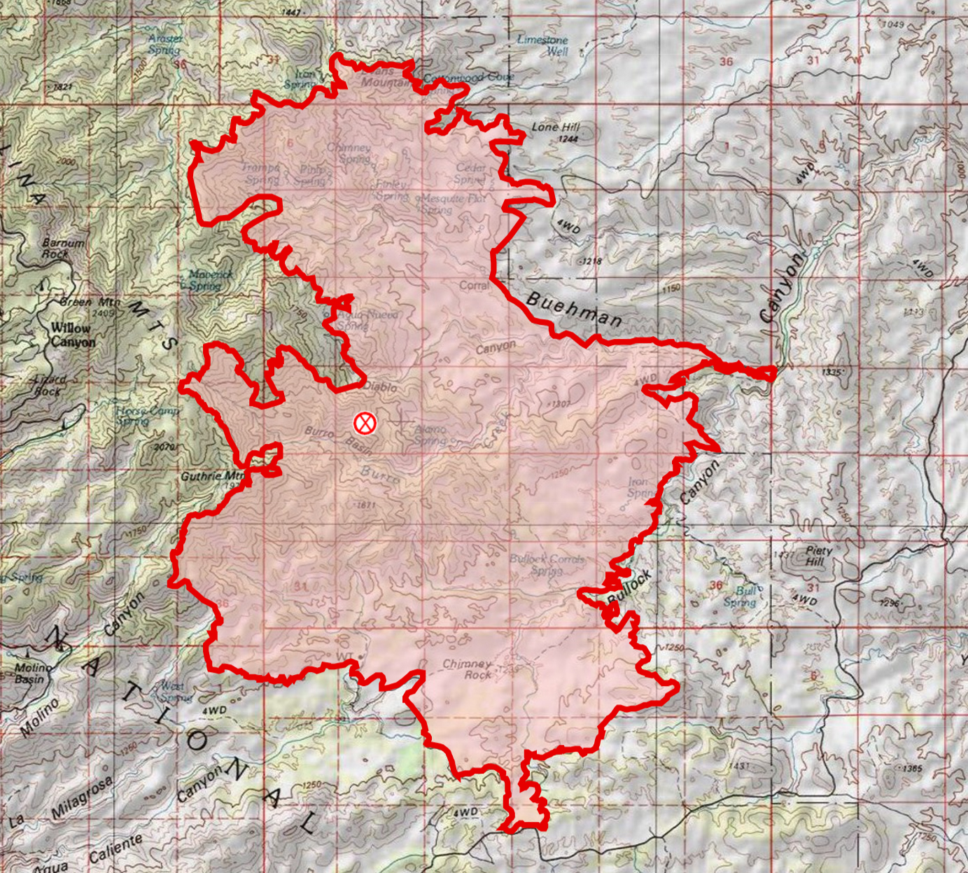
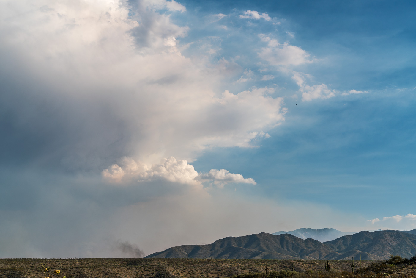
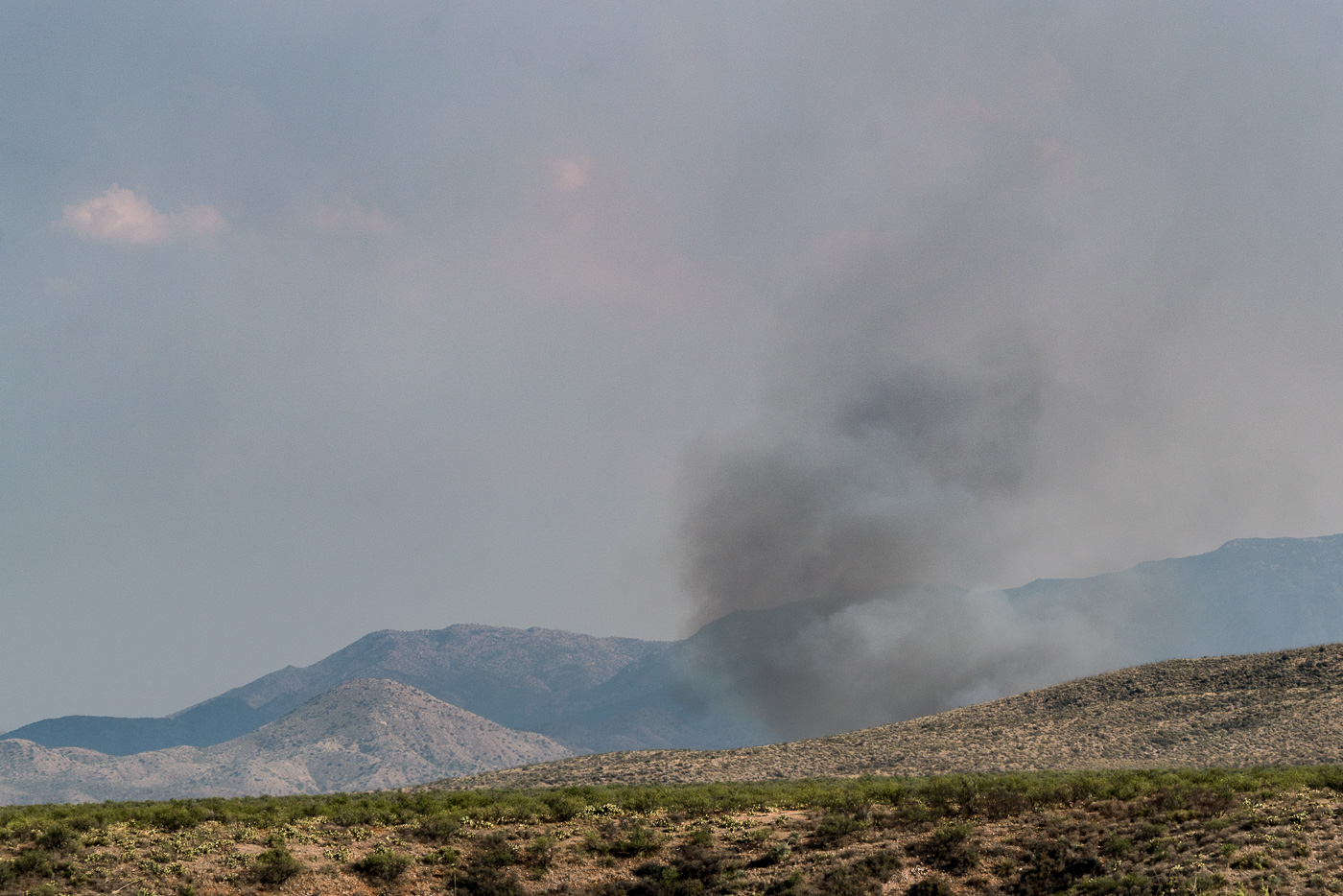
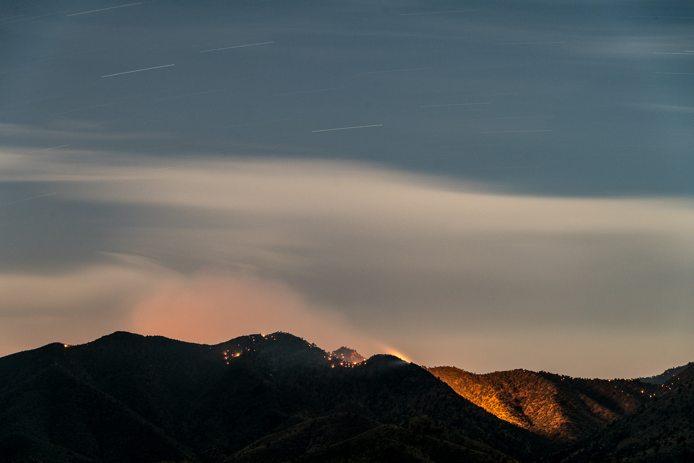
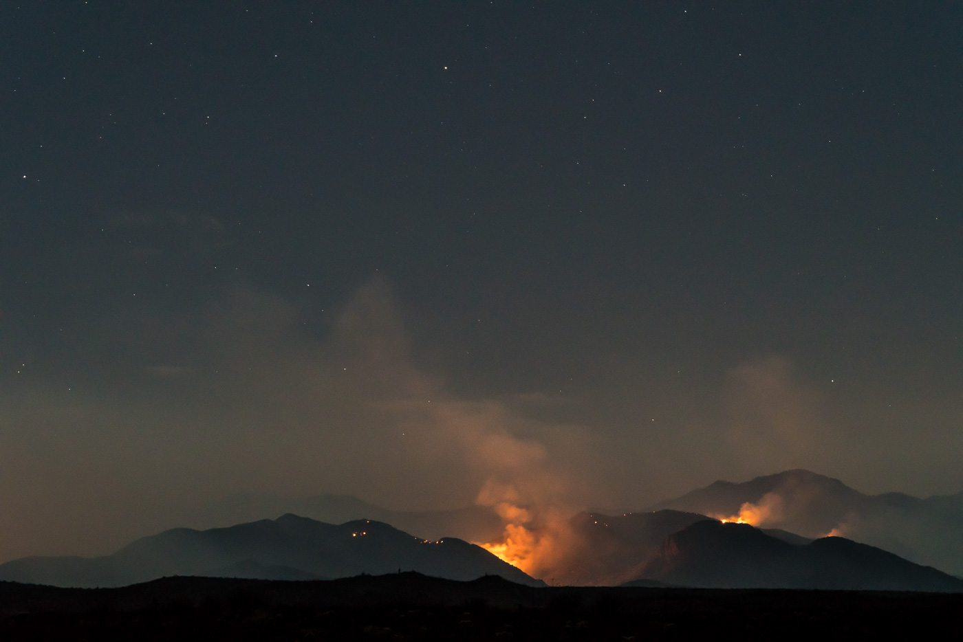
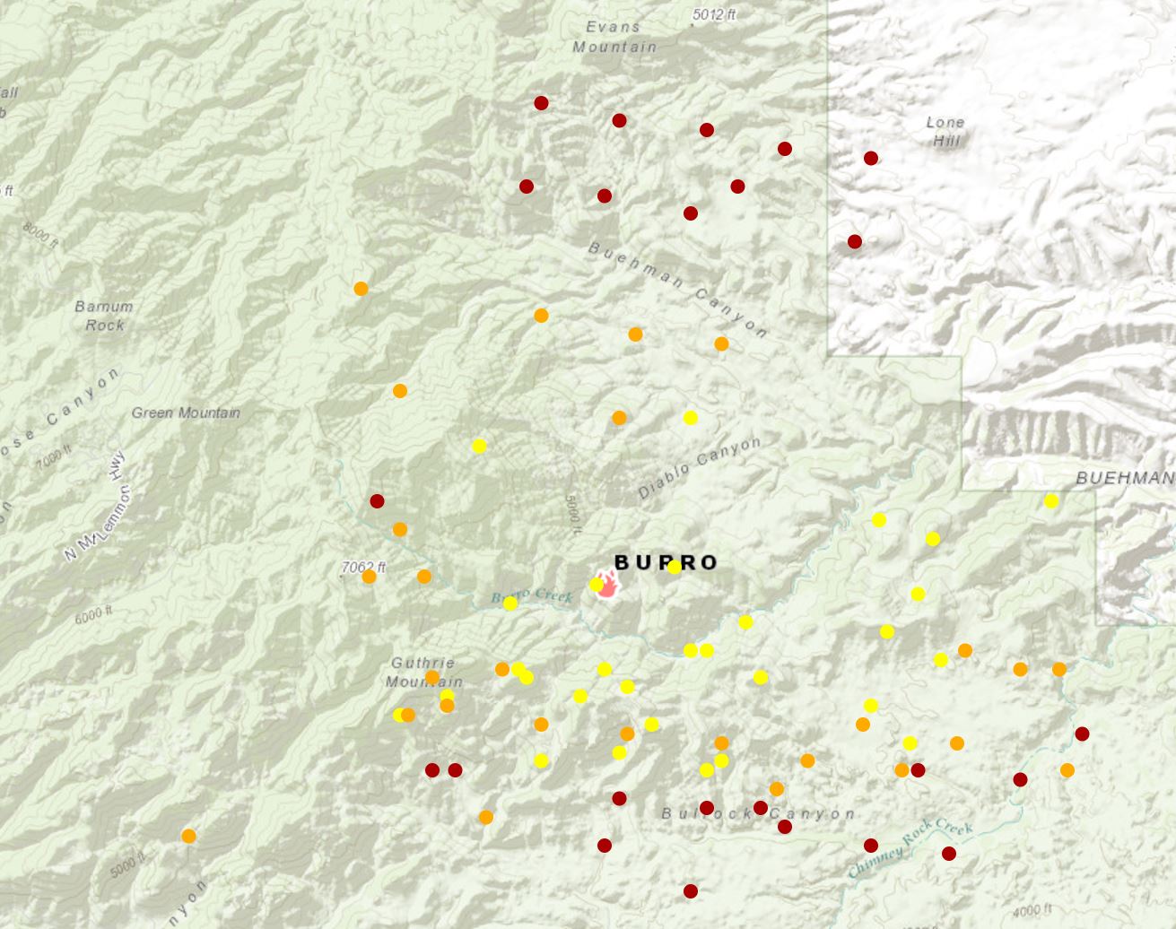
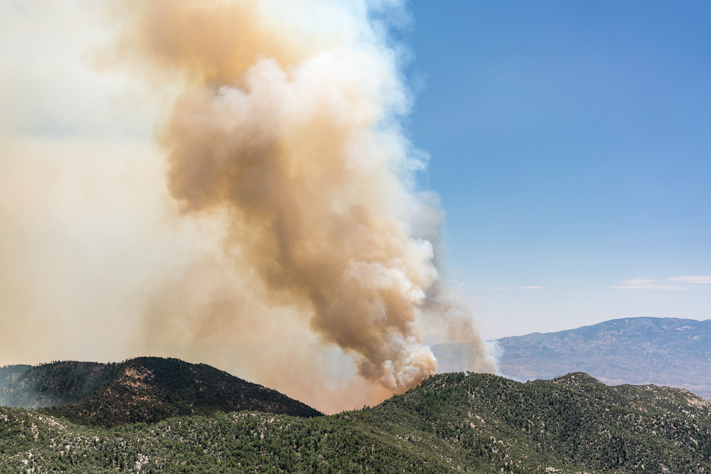
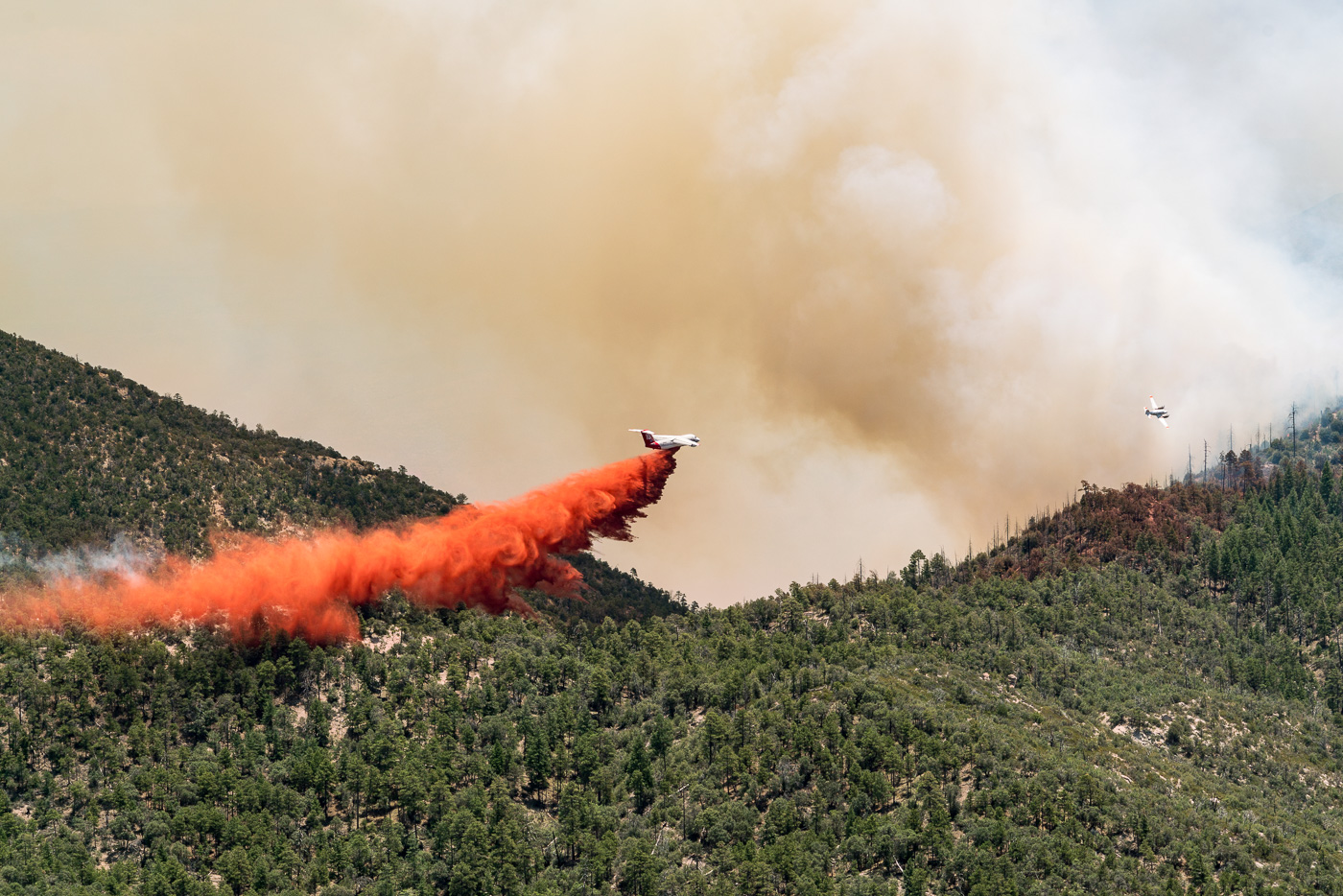
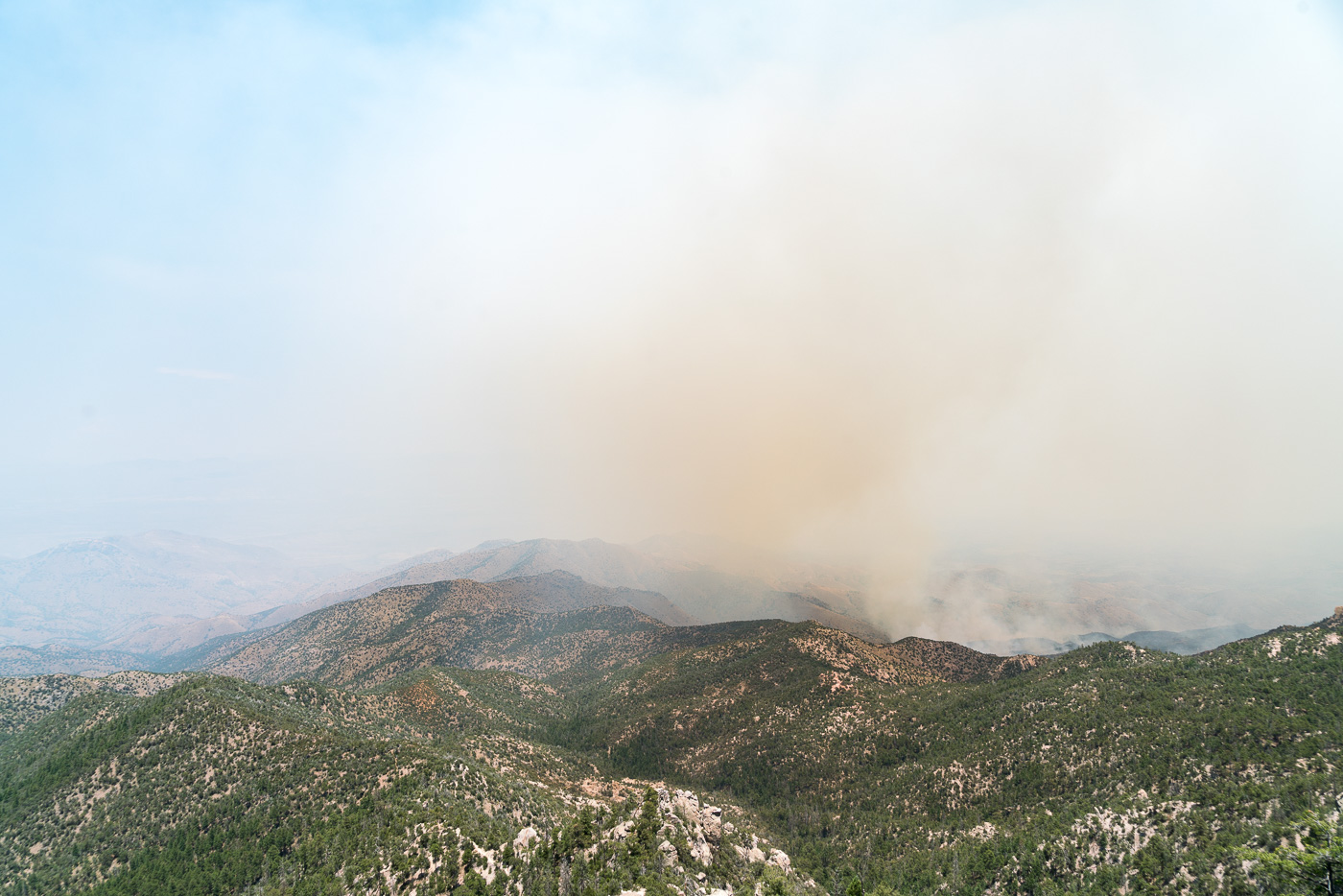
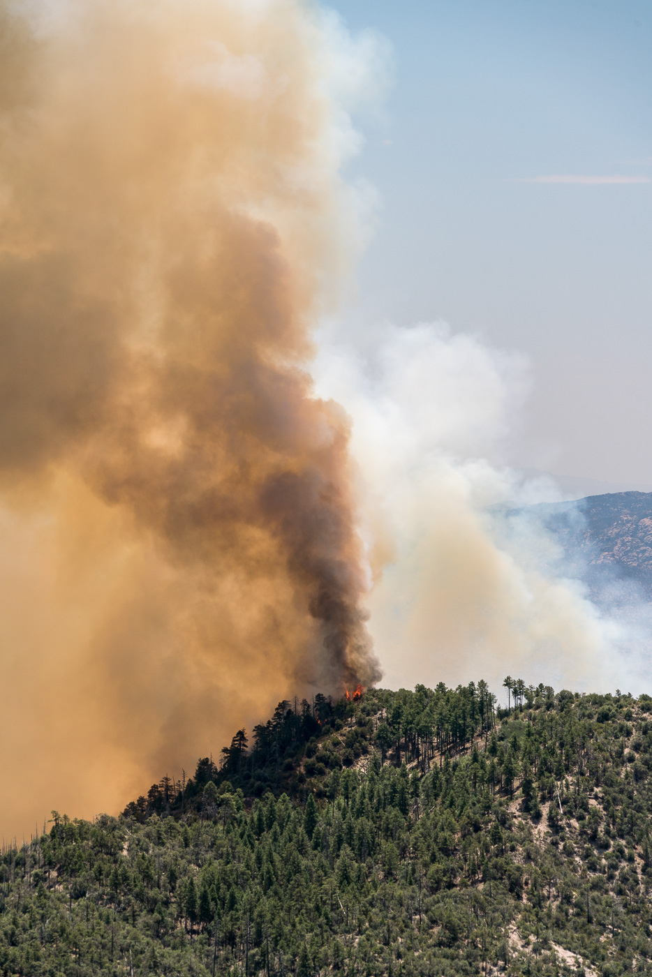
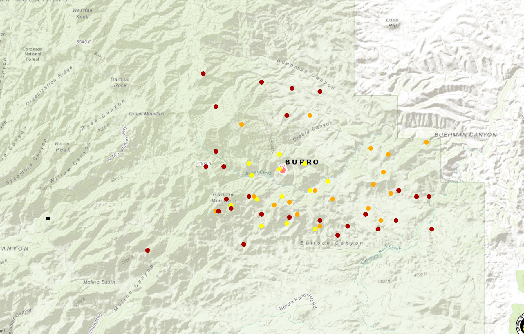
News links from the past few months for the Santa Catalina Mountains – this post was over due already in late June when I was working on finishing it but it was delayed several additional weeks by the Burro Fire. The Burro Fire burned over 27,000 acres in the Santa Catalina Mountains but did not destroy any homes/buildings/infrastructure – news links, maps, pictures and other information from the Burro Fire can be found here.

Pine scents, cold streams, ladybugs: Moments and memories on Mount Lemmon | Home + Life + Health | tucson.com – Arizona Daily Star: A short article of selected memories of the mountain that were submitted to the paper via Facebook – this was prompted by the Burro Fire and it made me think about all the personal stories about the mountain that we never get to hear…

Permit to operate Sabino shuttle to be opened for ‘competitive process’ – Arizona Daily Star, Sabino Canyon shuttle service to continue – KGUN9: For now the current shuttle will continue to operate while the Forest Service continues to take and evaluate bids to run the shuttle service. The Forest Service took public comments on this process in October 2015 and I think it is fair to say that many people hope to see improvements to the shuttle system – after seeing this article it was interesting to go back and read the 2015 letter from the Forest Service…

Giving back in Southern Arizona | Business News | tucson.com – Arizona Daily Star: “Summit Hut raised $1,500 for Friends of Oracle State Park, a 4,000-acre wildlife refuge in northern foothills of the Catalina Mountains. It serves as a center for environmental education while providing programming for all ages through interactive programs, trails and avenues for interrelationships and habitats between plants, animals and people.” The Friends of Oracle State Park have done great work over the years and this March the park opened full time for the first time in years!

Southern Arizona Rescue Association looking for new volunteers – KGUN9: SARA is an outstanding group that has helped a huge number of hikers/climbers/canyoneers/riders/etc.!!! Tuesday July 18th, 2017 from 19:00 to 21:00 is the next orientation for people interested in joining. New applicant recruitment is done once a year – for more information see this page.

Sonoran Desert wildlife passages win partnership award – Tucsonlocalmedia: The North Oracle Road widening that took place last year included a wildlife crossing bridge and underpass – the work that the Arizona Department of Transportation did in coordinating and collaborating on the wildlife crossings earned it the 2017 Timothy M. Ahrens Partnering Award from the Pima Association of Governments and the Regional Transportation Authority. These crossing help provide a much needed link between the Santa Catalina Mountains and the Tortolita Mountains – two interesting sources for more information are the Coalition for Sonoran Desert Protection‘s results from the effort to monitor the crossings and AZGF’s funding proposal for a study of the wildlife linkage.

Stranded bighorns – High Country News: A letter to the editor about the Bighorn Sheep in the Santa Catalina Mountains – the paragraph that caught my attention: “The bighorn release area in the Pusch Ridge Wilderness is hemmed in right up to the Coronado National Forest and wilderness boundary by dense urban development. The bighorn are stranded on a “mountain island.” How will that herd maintain genetic diversity without manipulation by humans?”

 Southern Arizona Authors – Arizona Daily Star: A nice review of John Bezy’s A Guide to the Geology of the Santa Catalina Mountains, Arizona: The Geology and Life Zones of a Madrean Sky Island.

Bears, Mountain Lions and even a rabid fox were concerns over the past few months – probably the most memorable item from the articles below is the picture of a bear looking thru the window into a Summerhaven cabin:

The commercial horseback rides on the Linda Vista Trails continued to generate quite a bit of commentary – the permit for the rides was not renewed and the rides have ended.

Hikes and destinations:

Events:

Rescues/Accidents/Incidents including information from the SARCI Newsletter:

  • 4/6/2017 Bear Canyon Trail: Exhausted hiker about x7 was given refreshments, helped down to the Horse Around and assisted out on horseback
  • 4/12/2017 Box Camp Trail: A hiker was unable to find a way out of Sabino – found and assisted up the Box Camp Trail
  • 4/15/2017 Nancy’s Thumb, above North Fin in the Windy Point Area: A climber soloed up Nancy’s Thumb (5.4) but was unable to get down – an anchor was set and the climber lowered down and assisted back to Windy Point
  • 4/22/2017 7 Falls, Bear Canyon: A hiker falls and hits his head and feels poorly – helped with hydration and then assisted out on foot and horseback
  • 4/23/2017 Pontatoc Trail: A fall results in an ankle injury – carried out
  • 4/23/2017 Esperero Trail: On the return trip from Bridalveil Falls hikers ran out of water – one continued to the Visitors Center for help. The hiker still on the trail was given refreshments and was able to hike out
  • 4/23/2017 7 Falls, Bear Canyon: Ankle injury – carried out but at x7 reported loss of sensation in her foot – hoisted out by helicopter
  • 5/6/2017 7 Falls, Bear Canyon: A group looking for Seven Falls hiked up Sabino and down Bear – one hiker became exhausted just above the falls – given refreshments and iked out.
  • 5/7/2017 Knagge Trail: A hiker attempting to follow the Knagge Trail got lost and continued off trail before calling for help. A care package was dropped by helicopter, SARA teams met the hiker and they hiked out.
  • 5/7/2017 Bear Canyon Trail: Three hikers without lights are met and assisted out
  • 5/19/2017 Red Ridge Trail: Two horses and riders set off down the Red Ridge Trail – one horse spooked and ended up down a steep brushy slope in the bottom of a drainage. A path was cleared and the horse was able to walk back up the to the trail and out without assistance. Horse rescue draws multi-agency response on Mt Lemmon – KVOA.com, HAPPY ENDING: Horse rescued on Mt. Lemmon, minor injury – KVOA.com
  • 5/20/2017 Romero Canyon: Hikers try to hike back from Romero Pools via the canyon bottom – several end up exhausted – met and given refreshemnts near the mouth of the canyon – assisted out.
  • 5/20/2017 Sutherland Trail: Hikers reach the powerline but exhausted and out of water call for help. They were able to continue up slowly – meanwhile there ride at the top of the mountain went down the Lemmon Rock Lookout Trail to meet them, but the were on the Mount Lemmon Trail – they were found and accompanied back up.
  • 5/23/2017 Wilderness of Rocks: Two hikers planning on hiking up the Lemmon Rock Lookout Trail end up in the dark without water – assisted out.
  • 6/1/2017 Mt.Kimball Area: Hikers see a bear and after calling for help are advised to head downhill away from the bear – disoriented they started down into Ventana before realizing their error and turning around – met and assisted back to the trailhead.
  • 6/3/2017 Bear Canyon Trail: Exhausted hiker at the first crossing escorted out
  • 6/4/2017 Bear Canyon Trail: Two xxhausted hikers are given refreshments – one rode out by horse, one hoisted by helicopter. Rescues underway for two hikers near Seven Falls – KVOA.com, Two hikers rescued in Sabino Canyon – KGUN9
  • 6/18/2017 Whitetail Group Area: Lost while hiking around the area – found.
  • 6/18/2017 Esperero Trail: After going up the Ventana Trail and the hiker ran out of water on the Esperero Trail and was unable to continue. Met, given refreshments and assisted out.
  • 6/19/2017 Romero Pass: A hiker coming up from Catalina State Park gets lost above Romero Pass – located, given refreshments and assisted to the top.
A summer storm over Samaniego Ridge from the Golder Ranch area. July 2017.

Piety Hill – 7/11/2017

Looking South from Piety Hill. July 2017.

Redington Road had been closed since the start of July due to the Burro Fire – on the first day that it re-opened I drove out along the fire perimeter and hiked to the top of Piety Hill. The Burro Fire was stopped west of Piety Hill and in the sunset light it was hard tell where the Burro Fire burned – I am sure that there are areas that were heavily impacted by the fire but from Piety Hill I can still see green trees and grass below.

Piety Hill's shadow towards the San Pedro Valley. July 2017.
Piety Hill’s shadow towards the San Pedro Valley. July 2017.

Piety Hill is located on Pima County’s A7 Ranch – at 4,714′ it is not stunning high (‘Hill’ is the right name) – but it is high enough to overlook the San Pedro Valley and offer great views of the surrounding terrain! There is no official trail to the top, but the terrain, while steep, is reasonably open and it is not hard to find a way to the top.

Looking up into the Santa Catalina Mountains from Piety Hill - Mount Bigelow on the left, Westfall Knob in the center. July 2017.
Looking up into the Santa Catalina Mountains from Piety Hill – Mount Bigelow on the left, Westfall Knob in the center. July 2017.
Balloon Trash on the slopes of Piety Hill. July 2017.

Apache Peak – 7/9/2017

Looking south from Apache Peak. July 2017.

From the Lower Oracle Ridge Trailhead it is about 4 miles to get to the top of Apache Peak located on the north end of the Santa Catalina Mountains. Most of the miles are on the Oracle Ridge Trail which traverses below the peak, but there is no established trail for the final steep climb, and in my experience while you can pick better/worse ways to the top there probably is not a ‘great’ way up (the climb is not overly long but expect the standard rocky/loose/brushy off-trail Santa Catalina hillside…).

Sun disappearing behind the clouds at the end of the day on Apache Peak. July 2017.

I arrive at the top just in time for the last light on the ridges to the south, the sun dipping below the clouds on the horizon, city lights coming on thru Charouleau Gap and the moon peaking thru the clouds as it rises over the San Pedro Valley – but tonight it is what I don’t see that is the surprise: no glow from the Burro Fire (currently at just over 27,000 acres), no spots of flame visible on the distant ridges and no obvious/large columns of smoke! The Burro Fire is burning to the south – Apache Peak certainly doesn’t have a view directly into the active part of the fire, but I suspect that the fire would have been clearly visible from here several days ago…

Watching the moon rise over the San Pedro Valley from Apache Peak. July 2017.

Clouds covering the moon make the hike back down surprisingly dark – spider eyes glint in the headlamp beam and when I finally slow down to look more closely it turns out to be many more spiders than I thought…

A spider - and many/mini spiders... On the Oracle Ridge Trail. July 2017.
A spider – and many/mini spiders… On the Oracle Ridge Trail. July 2017.

Burro Fire

The Burro Fire started on June 30th near Burro Tank in the Redington Pass area – the fire burned 27,238 acres.

Final Update

On 7/13/2017 a final update was issued on Inciweb – the mountain will re-open on 7/14 8am and and all closures will be lifted so that all trails/trailheads on the mountain will be open!! The final size of the fire is estimated at 27,238 acres. The containment is listed at 95% (there is a small area on the NW side of the fire that on the last map still has active perimeter marked). The cause is still listed as ‘Under Investigation’.

Burro Fire Topo Map - Final Update. July 2017.
Burro Fire Topo Map – Final Update. July 2017.

7/12/2017

8:02 AM: The Burro Fire’s estimated acreage remains the same at 27,238 and containment is now reported as 74% – only the northwest portion of the fire remains as active perimeter on the current map and there is a decreasing number personnel committed to the fire. With the highway up the mountain likely to open Friday for the general public there is now a revised closure order. Trails that are closed: Crystal Spring Trail, Butterfly Trail, Green Mountain Trail, Maverick Spring Trail,  Bug Spring Trail, Brush Corral Shortcut Trail, Guthrie Mountain, Knagge Trail, Bigelow Trail, Davis Spring Trail, Incinerator Ridge Trail and Kellogg Trail.

On 7-11-2017 a revised closure order was issued ahead of the anticipated opening of the highway up the mountain to the general public on Friday. July 2017.
Burro Fire - 7/12/2017 8AM - At 74% containment the only active perimeter remaining is on the NW side of the fire. July 2017.
Burro Fire – 7/12/2017 8AM – At 74% containment the only active perimeter remaining is on the NW side of the fire. July 2017.

7/11/2017

Evening: I drove Redington Road to Piety Hill to get a quick look at the impacts of the fire and fire fighting. Close to the road in the burned areas I could see the grass was gone, some or many trees were still standing and in some spots green vegetation was still visible. There were ridges in the distance that looked like they burned hotter – and near the road some of I saw was probably controlled burning by fire crews – but thankfully, at least near the road, the landscape was not a desolate moonscape!

Off Redington Road grass and underbrush were clearly burned but many trees remained. July 2017.
The Burro Fire was stopped at Redington Road and in this view you can see the green vegetation south of the road and burned area north of the road. July 2017.
The start of the Bellota Trail - part of the Arizona Trail - at the Italian Spring Trailhead. July 2017.
The start of the Bellota Trail – part of the Arizona Trail – at the Italian Spring Trailhead. July 2017.

6:40 AM: Yesterday evening 65% containment was announced – and perhaps more telling about the state of the fire residents, business owners and business employees were allowed back up the mountain starting at 3pm yesterday and at this time no additional community meetings are scheduled! (The incident commander, Bea Day, did not give any estimate on when the mountain would be open to the general public.) Redington Road is now open to all traffic. The fire is listed at 27,238 acres. The current map reflects the increased containment with more of perimeter marked as contained on every side of the fire! Rain again last night should help dampen the fire and increase containment (Green Mountain, Dan Saddle and Redington gauges all show rain in the last day on the Pima County ALERT map).

Burro Fire -7/11/2017 6:39AM - the map reflects the 65% containment announced yesterday!. July 2017.
Burro Fire -7/11/2017 6:39AM – the map reflects the 65% containment announced yesterday!. July 2017.

7/9/2017

7:38 AM: 27,266 Acres, 51% Contained. Fire crews finished prepping the Control Road yesterday and added more dirt road/dozer lines to the map – the extensive circle of preparations can be seen on the map! Fire growth in Edgar Canyon was minimal even though hot/rugged conditions meant that there were not crews in the Peck Basin area yesterday – the fire continues a slow spread to the east, with hot conditions limiting crews on the ground and established lines to the east the fire is being allowed to grow in that direction for now. Progress was made containing the fire in the Piety Hill, Buehman Canyon and Guthrie Mountain areas.

7/9/2017 7AM - Burro Fire - minimal fire growth and additional containment!. July 2017.
7/9/2017 7AM – Burro Fire – minimal fire growth and additional containment!. July 2017.

7/8/2017

7:40 AM: Inciweb was updated this AM to report 26,731 acres burned and 36% containment. Fire growth shown on the map this AM is modest. Fire crews with air support have been able to stop the fire at Edgar Canyon and prevent the fire from moving west into the Peck Basin area – east of this area the map now shows a much more extensive set of fire lines surrounding the fire. The southeast portion of the fire has quite a bit less active fire perimeter with area near Buehman Canyon and Piety Hill now shown in black.

Burro Fire - 7/8 AM Map - compared to the 7/7 AM map there are additional fire lines on the north and east side of the fire with only modest additional areas burning on the north and west sides. July 2017.
Burro Fire – 7/8 AM Map – compared to the 7/7 AM map there are additional fire lines on the north and east side of the fire with only modest additional areas burning on the north and west sides. July 2017.

7/7/2017

5:30 PM: At the community meeting they just announced 36% containment. There is a news article below about two injured firefighters – at the meeting there was a question about the injuries and it was mentioned that they were minor and the firefighters were back at work.

7:20 AM: Inciweb lists the Burro Fire at 25,355 acres and 19% contained. Compared to yesterday note the growth in the Edgar Canyon/Peck Basin area – this area was mentioned multiple times in the Community Meeting last night in part because of the concern that the fire could burn up from this area towards the highway. The map this AM also adds a substantial number of firelines compared to yesterday AM. The southwest side of the fire is now contained. On the west side preparations to hold the fire at the highway have been made including plans for burnouts if needed. On the east side a line has been established from Black Hills Mine Road, across Alder Canyon at Ventana Windmill, out Davis Mesa, across Edgar Canyon down to Lone Hill and then towards the Brush Corral Area (Black Hills Mine Road connects to the Control Road which has been mentioned as a feature that could be used to control the fire – if this line + the Control Road + the highway was held it would encircle a large section of the fire). 

7/7/2017 6:50 AM - Burro Fire Map - compared to Thursday AM there has been growth in the Edgar Canyon/Peck Basin area and a substantial number of fire lines added. July 2017.
7/7/2017 6:50 AM – Burro Fire Map – compared to Thursday AM there has been growth in the Edgar Canyon/Peck Basin area and a substantial number of fire lines added. July 2017.

7/6/2017

7:30 AM: The Burro Fire is currently listed as 24,547 acres with 11% containment. The map as of this AM shows the south side of the fire – along Redington Road – as contained. Since yesterday AM the northern section of the fire has grown and is burning down towards Edgar Canyon.

AM Map from July 5th - on the NE side the fire has burned down towards Edgar Canyon, on the south side there is now a significant stretch of fire line that is no longer marked as active. July 2017.
AM Map from July 5th – on the NE side the fire has burned down towards Edgar Canyon, on the south side there is now a significant stretch of fire line that is no longer marked as active. July 2017.

7/5/2017

Evening/Night: Driving north from Benson the fire came into view well before the junction with Redington Road – sun, smoke and fire created several amazing views from the road. Black Hills Mine road is now closed – but with Evans mountain and the slopes down into Edgar Canyon burning the fire was easy to see from Redington Road after it climbs away from the San Pedro. The evening update puts the fire at 24,547 acres 11% contained.

Sun and Smoke from Cascabel Road. July 2017.
The Burro Fire from Cascabel Road. July 2017.
Evans Mountain and the slopes below burning in the Burro Fire on the night of the 5th. July 2017.

From Inciweb:

  • Today, firefighters strengthened control lines along the Redington Pass Road and after cold trailing and mop up of the line, declared that this section of fire perimeter is now contained. Tonight, engines will patrol the area and extinguish hot spots as needed. No additional fire growth is expected in this area.
  • Prep work along the Catalina Highway is nearing completion. Fire crews have reinforced Firewise mitigations put in place by residents and have set up contingency fire lines as a defensive measure. Crews are prepared to initiate burning operations in front of the fire, should it move westward, threatening structures and other values at risk.
  • Tonight crews will be patrolling the south eastern perimeter of the fire. Winds are predominately coming from the southeast, pushing the fire back onto itself.
  • The northeastern side of the fire will be monitored through the night. Incident Fire Behavior Analysts do not anticipate any substantial fire spread in this area over night.
  • The most active fire behavior on the Burro Fire was observed on the northwestern perimeter. In this section the fire has dropped into canyons where the vegetation is predominantly grass and scrub. Helicopters and fixed wing aircraft were used to impede the fires progress. Under current weather conditions, these canyons are in alignment with the wind, so that fire has the ability to move quickly through the light flashy fuels.

Media Coverage:

7:10 AM: Inciweb was updated this AM to list the fire at 21k acres – several notes from the update:

  • There will be a Community Meeting 5:30 p.m., Wednesday July 5, 2017, at the Sahuaro High School, 545 N. Camino Seco, Tucson, AZ 85710. American Sign Language (ASL) and Communication Access Real-Time Translation (CART) captioning will be provided. The meeting will be live streamed on Facebook https://www.facebook.com/BurroFireInfo/
  • Fire crews continued patrolling and preparing homes and other structures along the Catalina Highway. They also surveyed the terrain between the fire’s western edge and the highway to determine locations where defensive measures might be taken should the fire encroach upon the roadway.
  • With the support of heavy helicopters and fixed wing aircraft, fire crews built fire line along the southern and eastern flanks of the fire to protect infrastructure as well as cultural and recreational values, and were able to hold the fire north of Redington Pass Road. Despite dry conditions, high heat and outflow winds, firefighters were able to successfully protect ranch buildings in those areas. To date, the suppression efforts have ensured that no structures have been burned.
  • The terrain on the north eastern side of the fire is rugged and mountainous. No roads exist that would provide access for fire apparatus. Given the topography and lack of access, the decision has been made to rely mainly on air resources to slow the fire’s progress in this area. Contingency plans are in place, should fire activity become a threat to infrastructure as well as cultural and recreational values.

In the maps this AM I noticed two interesting details:

  • The satellite information on the fire suggests that the fire has made notable progress over the Evans Mountain area and is much closer to Edgar Canyon and Peck Basin.
  • The maps reflect the note above about holding the fire north of Redington Road – the fire perimeter on the south-east now runs along Redington Road.
Satellite information suggests that the fire has made significant progress over Evans Mountain and towards Edgar Canyon and Peck Basin. July 2017.
Burro Fire Map 7/5/2016. July 2017.

7/4/2017

Inciweb currently lists the fire at 14,112 acres although more notably the maps from the AM show quite a bit of movement to the south. From Inciweb:

  • Beginning July 4, Burro Fire Public Information Officers will provide media briefings at 7am and 7pm daily at the Incident Command Post at Sabino High School, 5000 Bowes Road, Tucson Arizona.
  • The Coronado National Forest has now implemented forest closures from Redington Pass Road and the National Scenic Trail north including Catalina Highway and the Control Rd. to the Pima/Pinal County line. These closures can be found athttps://www.fs.usda.gov/coronado/
Burro Fire Map 7/4 7:25 AM - since yesterday there has been considerable growth to the south. July 2017.
Burro Fire Map 7/4 7:25 AM – since yesterday there has been considerable growth to the south. July 2017.
Burro Fire Topo Map from 7/4 7:25 AM. July 2017.

7/3/2017

Evening/Night: With the Control Road and Highway up the mountain both closed I drove around the north end of the mountain and took Black Hills Mine Road out to the edge of Alder Canyon – this didn’t give me a view of the more active south side of the fire, but it did let me watch as flames and smoke rose from the Evans Mountain area. For the most part the fire stayed behind the ridge – but as night fell all of the small hot spots, hidden in the days, became visible… From Inciweb:

  • Firefighters made good progress on the Burro Fire. Indirect line construction and structural protection continued to be the focus along the Catalina (Mt. Lemmon) Highway. On the south side of the fire, firefighters continued preparation along the Redington Pass Road. Natural barriers are also being used to aid in suppression efforts. Airtankers and helicopters were used to help delay the fire’s spread where they could be used safely and effectively. With extreme temperatures, we expect to continue to have periods in the afternoons when it’s too hot to fly.
  • Today’s fire spread was primarily in the southern area of the fire. Firefighters provided structural protection at the Bellota Ranch.
  • Forest Service Closure Order
Smoke and clouds over the Evans Mountain Area. July 2017.
A plume of smoke east of the Evans Mountain area with Piety Hill on the left. July 2017.
Burro Fire - Evans Mountain. July 2017.
Burro Fire – Evans Mountain. July 2017.
Burro Fire in the Evans Mountain Area with Green Mountain in the background - from Black Hills Mine Road. July 2017.
Burro Fire in the Evans Mountain Area with Green Mountain in the background – from Black Hills Mine Road. July 2017.

11:00 AM: Several new details from a recent news releasea recent news release:

There will be a Burro Fire Community meeting tonight, July 3, 5:30 p.m. at the Sahuaro High School (545 North Camino Seco, Tucson AZ). Please park in the main parking lot the meeting will be in the auditorium. The meeting will be live streamed on Facebook https://www.facebook.com/BurroFireInfo/. You must have an account to view the stream live. Following the meeting the recording will be posted, this will not require an account to view.

Firefighters are actively working to fully suppress the Burro Fire. Due the steep, rugged, inaccessible terrain and fire activity, firefighters are currently using indirect tactics. On the west side of the road, firefighters are planning and implementing structure protection along Catalina Highway. On the south side of the fire, firefighters are scouting and planning for preparation on holding the Redington Road. Airtankers and helicopters are being used to help delay the fire’s spread where they can be used safely and effectively. With extreme temperatures, we expect to continue to have periods in the afternoons when it’s too hot to fly.

There are currently 185 personnel working on the fire. Current resources include three hand crews, 14 engines, one water tender, and three helicopters.

6:30 AM: Evacuations have been extended – evacuations in Summerhaven were scheduled to start at 6am this morning. Inciweb now lists the fire at 14,000 acres – up from 5,000 listed yesterday. In the map below from the The National Wildfire Coordinating Group (NWCG) it appears that the movement on the north side of the fire has been considerable – the fire has burned across Buehman Canyon and certainly looks like it will burn thru the Evans Mountain area. From Inciweb planned actions: “Assess options for indirect line construction and containment using natural barriers. Assess needs for point protection at threatened infrastructure/communities.”

National Wildfire Coordinating Group (NWCG) Map - 7/3/2017 6:17am. July 2017.
National Wildfire Coordinating Group (NWCG) Map – 7/3/2017 6:17am. July 2017.

7/2/2017

In the AM driving up the mountain the usual traffic was out on the road, you could barely smell the smoke and lower down on the mountain you had to look in the right direction to even know there was a fire. Higher on the mountain the smoke became more and more obvious… I hiked out to several points below Green Mountain to watch the fire – the smoke was impressive, scary, and larger than I expected. I watched cautiously for an hour or so as flames came up onto a ridge near Guthrie Mountain and aircraft dropped fire retardant to try to keep it in the canyon… Driving down the mountain I noticed fire personnel coming down and at the base Police had started to turn away anyone who was not a resident.

Smoke from the Burro Fire - Guthrie Mountain to the left. July 2017.
Smoke from the Burro Fire – Guthrie Mountain to the left. July 2017.
Airplanes drop fire retardant on flames trying to come over a ridge - near Guthrie Mountain. July 2017.
Airplanes drop fire retardant on flames trying to come over a ridge – near Guthrie Mountain. July 2017.
Looking down into a smoke obscured the San Pedro Valley - Edgar Canyon on the left. July 2017.
Looking down into a smoke obscured the San Pedro Valley – Edgar Canyon on the left. July 2017.
Smoke and flames from the Burro Fire. July 2017.
  • 5,000 acres (7/2/2017, 11:37:15 AM)
  • Redington Road closed from milepost 2 to 14 due to Burro Fire.
  • Burro Fire updates! Evacuations have started. They begin at mile marker 0 up to Palisades Road. North of Palisades Rd is under a pre evacuation status. We understand this decision is sudden however based on the activity of the fire this is the safest and best decision for our residents. Please follow social media and MyAlerts.pima.gov for more updates to follow. Pima County Office of Emergency Management can be found on Facebook at: https://www.facebook.com/pcoem/
  • Maps suggest that the fire is currently burning between Bullock and Buehman Canyons and is still east of the Green Moutain Trail and just inside the National Forest boundary to the East.
National Fire Situational Map from about 5pm on 7/2/2017 - the yellow/orange/red dots help show the Burro Fire. July 2017.
National Fire Situational Map from about 5pm on 7/2/2017 – the yellow/orange/red dots help show the Burro Fire. July 2017.

Sabino Canyon – 5/22/2017

Lower Sabino Canyon below the dam. May 2017.
The dryness and early summer heat are having their way with Sabino Canyon – just below the dam the water’s movement is nearly imperceptible and in the still pools strange patterns and stresses emerge – it feels like the canyon and I are both longing for the refreshing July rains…
The Gauge at the Sabino Canyon Dam - July is usually reliable for weather and rain, but every year is different... July 2017.
The Gauge at the Sabino Canyon Dam – July is usually reliable for weather and rain, but every year is different… July 2017.
Lower Sabino Canyon below the dam. May 2017.