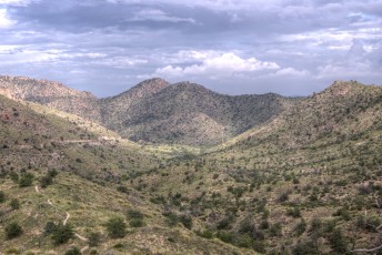
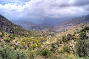
 Looking down towards Molino Basin from the Molino Basin Trail. August 2013.
Overview
The Molino Basin Trail #11 may be most popular as a link – part of the Arizona Trail, part of a number of popular Mountain Bike rides and part of a popular day hike to Sycamore Reservoir Trail. With a large part of the trail in view of the highway it was years of hiking in the Santa Catalina Mountains before I hiked all of this trail… While there are more rugged/remote/scenic trails this is a fun day hike, the miles near Molino Basin are quite fun and Shreve Saddle is always nice to visit.
Hike Stats
- Out and Back
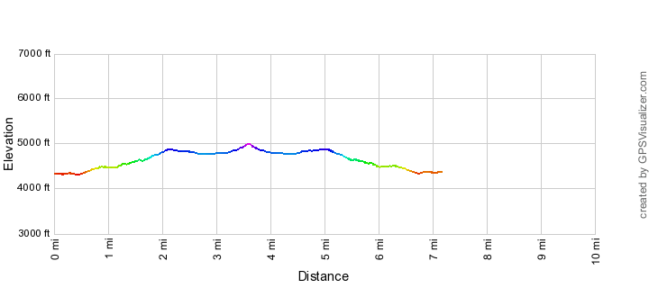
- 7.2 miles
- 1,250' Elevation Gain
- 1,250' Elevation Loss
- Highest Elevation: 5,000'
- Lowest Elevation: 4,300'
Location
- This hike is located off of the General Hitchcock Highway in the Santa Catalina Mountains north of Tucson, Arizona.
- Start/End: Molino Basin Parking Area (Lower Highway Hikes)
Details
- Fee: Yes (No fee for some uses - there are a limited number of free parking spaces for the hikers using the Arizona Trail (Molino Basin Trail and Bellota Trail))
- Dogs: Yes
- Bikes: Yes
- Part of the Arizona Trail
Drive
- 19.5 miles from Speedway and Campbell
- 40 Minutes from Speedway and Campbell
- Vehicle Access: Paved Roads/Passenger Car (Mountain Road - be careful of weather conditions!)
Molino Basin Trail Elevation Profile
Driving Directions
Suggested driving directions from the Speedway and Campbell intersection in Tucson to the Molino Basin Parking Area:
- Drive East on Speedway (5.0 miles)
- Left on Wilmot and continue on Tanque Verde (4.3 miles)
- Left on Catalina Highway (10.1 miles)
- Signs will help you find the turn into this trailhead and campground. This area is a fee area ([LemmonFeeCostAndLink]) - but there are a number of clearly signed free parking spaces for Arizona Trail users.
Google Maps Directions from the Speedway and Campbell intersection in Tucson to Molino Basin Parking Area.
[ImageTwoPictureSideBySide imagepathone=”/santa-catalina-mountains/molino-basin-trail/1410-Storm-over-the-Molino-Basin-Trail-and-Shreve-Saddle” captionone=”Storm over the Molino Basin Trail and Shreve Saddle. October 2014.” imagepathtwo=”/santa-catalina-mountains/molino-basin-trail/1308-Looking-up-at-Shreve-Saddle-from-the-Molino-Basin-Trail” captiontwo=”Looking up towards Shreve Saddle. August 2013.”/]
Trail Notes
[CueListWarning/]
- 0.0 miles, 4350′: Park in the Molino Basin Parking Area 5.6 miles up the General Hitchcock Highway [Waypoint THMB].
- The trail starts in the Northwest corner of the parking lot – it quickly crosses the (paved) road [Waypoint MB01] and passes several side trails [Waypoints MB02 and MB03]. Pay careful attention as the trail winds thru/near the campground – there are a number of side trails to campground areas, if you walk ‘thru’ a campsite you have probably lost the trail…
- 0.4 miles, 4300′: Cross a wash/road [Waypoint MB04]
- 1.0 miles, 4450′: Signed junction with a trail down to the Molino Basin Campground [Waypoint J MB MBCG] – at 1.1 miles pass an unsigned junction down to the campground [Waypoint MB05]
- The trail climbs to a hillside just above the Gordon Hirabayashi Recreation Site.
- 2.2 miles, 4850′: Signed junction with a trail that connects to the Gordon Hirabayashi Recreation Site [Waypoint MB-BSC] (this trail starts at campsite at an old set of stairs just under a set of solar panels [Waypoint GHRS to MB]). After you pass this junction there are a number of other unofficial side trails down to the Gordon Hirabayashi Recreation Site campgrounds [in the area of Waypoint MB06].
- 2.5 miles, 4850′: Pass the large Molino Basin Trail – Soldier Trail sign near the end-of-the-road parking area [Waypoint MB07].
- 2.7 miles, 4800′: The signed junction with Soldier Trail [Waypoint SO-MB] – continue across the wash, the trail parallels the wash and then follows the sandy bottom and small shortcut trails.
- 3.2 miles, 4850′: Leave the wash and head uphill towards Shreve Saddle [Waypoint MB08]
- 3.6 miles, 5000′: The Molino Basin Trail ends at Shreve Saddle and the trail continues into the Pusch Ridge Wilderness as the Sycamore Reservoir Trail [Waypoint SR01].
 Stars and the highway from the Molino Basin Trail below Prison Camp. August 2013.
Resources
- Posts on HikeLemmon.com:
- Soldier Trail – 2/17/2019
- Box Camp Trail, Hutch’s Pool, out to Prison Camp – 9/23 and 9/24/2018
- Molino Basin Trail, Lost Sign – 4/21/2016
- Prison Camp, Thimble Peak, Bear Canyon – 11/28/2015
- Prison Camp to Sabino Canyon – 10/6/2015
- The Shreve Saddle Arizona Trail Sign
- Prison Camp to Avenida de Suzenu – Molino Basin, Bellota and La Milagrosa Trails – 2/4/2015
- Bigelow Trailhead to the Gordon Hirabayashi Recreation Site – 1/17/2015
- Gordon Hirabayashi Recreation Area to the base of Thimble Peak – 11/23/2014
- Storm: Point 5506, San Pedro Vista, Meadow Trail Loop – 10/9/2014
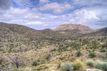
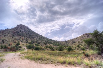
 Looking towards Prison Camp from Shreve Saddle. August 2013.
Pictures
2013 August Molino Basin Trail
Update Notes
- 2017/8/15 – Add posts from HikeLemmon
- 2014/10/24 – New picture, small layout change
- 2014/9/23 – Updated GPX file with slightly cleaned up track and waypoint names
- 2014/7/18 – Format update
- 2014/4/2 – Added new GPX file with waypoints and updated hiking notes
- 2014/3/2 – Move to WordPress, add elevation profile, Driving Directions, new format