The off-trail areas and/or unofficial trails used by this hike are currently CLOSED due to Bighorn Sheep Management Area Restrictions that are in place from January 1 to April 30 each year.
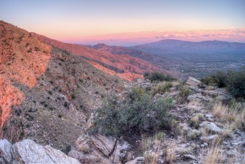
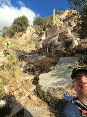
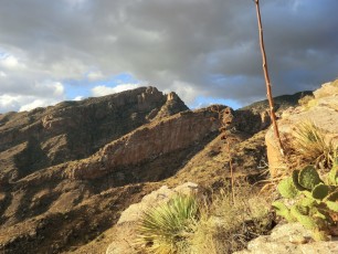
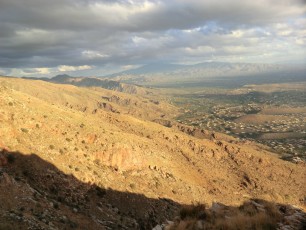
 Stunning light at the top of the cliffs - another great day in the Santa Catalina Mountains. November 2012.
Overview
The Pontatoc Ridge Trail is amazing, but going to the official end of the trail is likely to leave you wondering about the top of the cliffs towering above you… While it is unofficial, steep and not maintained there is a route to the top – if you are comfortable with the (essentially) off-trail hiking this trail requires it will take you up to a spectacular location! Note that the unofficial trail to the top of the Ridge is closed from January 1 to April 30 due to the restriction on travel more than 400′ off of designated Forest Service Trails in the Bighorn Sheep.
Hike Stats
- Out and Back
- 4.75 miles
- 2,350' Elevation Gain
- 2,350' Elevation Loss
- Highest Elevation: 5,000'
- Lowest Elevation: 3,050'
Location
- North side of Tucson, Pusch Ridge Wilderness, Santa Catalina Mountains.
- Start/End: Richard McKee Finger Rock Trailhead (City's Edge Hikes)
Details
- Fee: No
- Dogs: No (Bighorn Sheep Restrictions)
- Bikes: No (Pusch Ridge Wilderness)
- [OffTrailWarning/]
- [bighorn-management-area-restrictions/]
- [pusch-ridge-wilderness-restrictions/]
- [pima-county-trailhead-permit/]
Drive
- 8.4 miles from Speedway and Campbell
- 20 Minutes from Speedway and Campbell
- Vehicle Access: Paved Roads/Passenger Car
Pontatoc Ridge Elevation Profile

Driving Directions
Suggested driving directions from the Speedway and Campbell intersection in Tucson to the Richard McKee Finger Rock Trailhead:
- North on Campbell (6.4 miles)
- Right onto Skyline (0.4 miles)
- Left to continue on Skyline (0.7 miles)
- Left on North Alvernon Way (0.9 miles)
- The trailhead is on the left/west side of the road.
Google Maps Directions from the Speedway and Campbell intersection in Tucson to Richard McKee Finger Rock Trailhead.
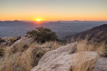
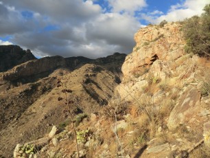
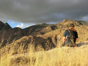
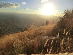
 A view west over the Santa Catalina Mountains after working up a steep section of unofficial trail onto the ridge. November 2012.
Trail Notes
[CueListWarning]
- 0.0 miles, 3040′: start at the Richard McKee Finger Rock Trailhead (parking for the Pontatoc Ridge Trail, Pontatoc Canyon Trail and Finger Rock Trail) [Waypoint thfr].
- Cross the road and walk north, several signs mark the beginning of the trail just after the entrance to a gated community.
- The trail climbs a short hill to a signed junction [Waypoint pc-fr] – take a right (left for the Finger Rock Trail) – the trail wanders thru the desert towards Pontatoc Ridge crossing several washes.
- 0.7 miles, 3250′: Cross Pontatoc Canyon [Waypoint PT01] (there are a number of wash crossing before crossing Pontatoc Canyon) – the trail begins to climb steeply.
- 0.8 miles, 3450′: Signed junction [Waypoint pr-pc] – take a right (left for the Pontatoc Canyon Trail) – in a few more minutes there is a nice rocky area just off the trail is a good spot for a break with nice views over Tucson [Waypoint PR02].
- The trail continues to climb – at 1.4 miles, 3550′ [Waypoint PR03] walk up a section of rocky slab – there are often several cairns to help you find the trail.
- 1.9 miles, 4100′: Saddle – great views! [Waypoint PR04]
- 2.0 miles, 4200′: A few minutes after the saddle look for a well worn trail the splits off to the right – the route to the right is the unofficial route up to the top of the cliffs (left continues to the end of the Pontatoc Ridge Trail. [Waypoint pr-pd]
- The trail continues climbing steeply up the hill side – the trail is indistinct in places – and eventually follows the ridge on the west side (near the cliffs) to the top – the best part of the trail! Don’t be fooled by the false summit as you come up the hill… The top will be at about 2.4 miles, 5045′. [Waypoint prdend]
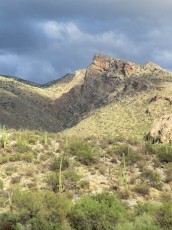
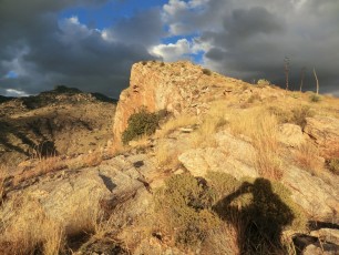
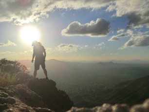
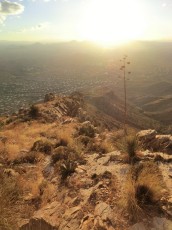
 Looking up the ridge towards the top! November 2012.
Although the cliffs were mined they are not the site of the ‘Pontatoc Mine’ that was worked in the early 20th century, the location of Pontatoc Mine is apparently somewhere inside the housing developments south of the ridge. The ridge/cliff area was prospected during and shortly after the Pontatoc Mine was producing, but what was found “apparently didn’t amount to much” – see The Pontatoc mine in a north Tucson neighborhood and Mineral investigation of the Pusch Ridge Wilderness, Pima County, Arizona for more information. The older name for this trail is the ‘Old Spanish Mine Trail’.
 At the saddle taking pictures of the moon. January 2014.
Maps
- [MapGreenTrailsCatalina] – only the official Pontatoc Ridge Trail is shown on the map.
- [MapSahcCatalina] – only the official Pontatoc Ridge Trail is shown on the map.
Resources
- HikeArizona.com
- AZDean – Tucson Hikes – Pontatoc Ridge Trail
- Chaoscanyon
- Mountain Project
- [GuideTucsonHikingGuide/]
- [GuideYellowBook/]
- Posts on HikeLemmon.com:
- Fenced Corridor, Rosewood Point, Campbell Trailhead – 12/22/2018
- Pontatoc Canyon Trail – 2/5/2017 and 2/9/2017
- Pontatoc Ridge – 12/18/2016
- Pontatoc Ridge Trail – 9/4/2016
- Window View, Flight from DFW – 11/14/2015
- Pontatoc Ridge – 5/7/2015
- Pontatoc Ridge End of Trail sign and Pontatoc Cliffs – 11/27/2014
- Pontatoc Ridge to the End of Trail Sign – 2014/1/1
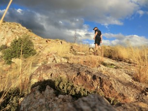
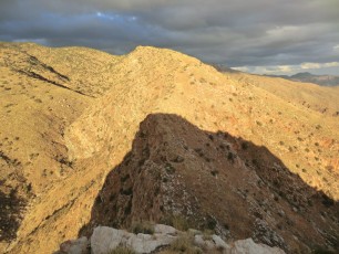
 Looking down the ridge. November 2012.
 City lights from the saddle. January 2014.
Pictures
2013 October Pontatoc Ridge
2011 November Pontatoc Ridge to the Top
Update Notes
- 2017/8/14 – Add HikeLemmon posts to Resources
- 2014/11/9 – Updated link to the Pontatoc Mine article (not sure of best link now for this)…
- 2014/10/29 – Small edits to GPX, updated page, fixed small typo, added PDF Map and Description
- 2014/7/27 – Format update
- 2014/4/1 – Improved GPX, waypoints/updated hiking notes
- 2014/3/8 – Update to WordPress, added elevation profile
- 2014/1/26 – Added small ‘driving’ map, increased the size of the Gmap4 Topo Map.
- 2014/1/19 – Updated Overview/Typos, added cautions and restrictions (esp. Bighorn Sheep related)
- 2014/1/18 – Updated format (driving directions, last update in overview), added dates to picture captions, added pictures, changed picture links.
- 2013/11/25 – Overview format updated for Location, history note, added a link to AZDean’s post in resources and added a number of new photo sets.
- 2013/10/14 – Updated format, added elevation and mileage notes, edited Notes add 2013 October Pontatoc Ridge flickr set.