The General Hitchcock Highway – often called the Catalina Highway – provides amazing access to the Santa Catalina Mountains. This page has hikes from the bottom of the highway up to the Bug Spring Trailhead.
For hikes listed by trailhead see Trailheads and Parking.
Recommendations
- Best Time of Year: These hikes are great winter destinations and generally fun to visit in the early Spring and late Fall – when the temperatures are warm/hot in Tucson none of these hikes are not really high enough up the mountain to be an escape from the heat and are generally very exposed to the sun…
- Top Pick: Sycamore Reservoir Trail – beautiful varied scenery, interesting history, part of the Arizona Trail.
- Best Workout Run: Bug Spring Trail – depending on your fitness this can be challenging – but it has mostly runnable hills, interesting terrain and fairly ‘smooth’ trails. This hike is part of the Arizona Trail Wilderness Bypass and for more challenge/distance you could continue along the Bypass up the Green Mountain Trail or down the Molino Basin Trail.
- Off-trail Challenge: Airmen Peak – great combination of two great canyons and a nice summit – but only if you are comfortable with off-trail hiking, canyon scrambling/problem solving and off-trail navigation!!!
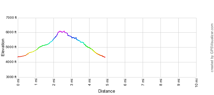
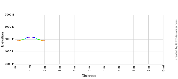
Airmen Peak
!!DO NOT attempt this unless you are comfortable with off-trail travel and navigation in the Santa Catalina Mountains!! A beautiful off-trail peak between Molino Canyon and the West Fork of Molino Canyon. Looking at the map Airmen Peak may seem ‘close to the highway’ – but don’t be fooled, navigating the rugged canyons and overgrown hillsides makes this quite an adventure.
- Two amazing canyons and one great peak make this a classic IF (and it is a big if…) you are comfortable with the RUGGED off-trail travel and off-trail navigation!
Airmen Peak Elevation Profile
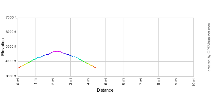
Babad Do'ag Trail
A short out and back hike above a nice canyon with a short section of lovely ridge.
- This is a nice short hike and while short the section of ridge over to the official end of the trail is fantastic – a decent choice on a mellow day.
Babad Do’ag Trail Elevation Profile
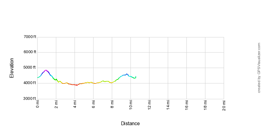
Bellota Trail
An interesting hike that takes you out of the Santa Catalina Mountains and across grassy hillsides into the Redington Pass area.
- This is an interesting hike and a great way to get into the Redington Pass area – the complete trail is a great experience – but the distance and logistics are a bit of a puzzle, your choices: a complete out-and-back at over 20 miles, a very long car shuttle or planning/coordinating a key-exchange…
Bellota Trail Elevation Profile
Bug Spring
A simple, quiet adventure on an old route – I rarely recommend this hike because there are so many more dramatic destinations in the Santa Catalina Mountains, but it is certainly beautiful. While this follows an old trail you should consider this an off-trail hike – if you are not comfortable traveling off-trail in the Santa Catalina Mountains DO NOT attempt this hike.
- This hike is probably best left to those who have done the ‘major’ hikes in the Santa Catalina Mountains and are looking to explore the details.
Bug Spring Elevation Profile
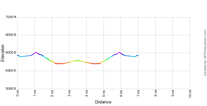
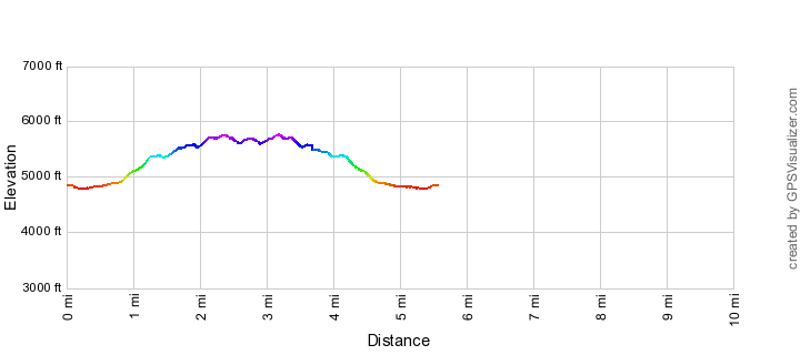
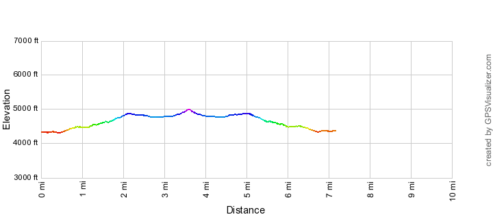
Bug Spring Trail
An interesting trail that runs from a Trailhead just above the Gordon Hirabayashi Recreation Site all the way to Bear Canyon and features good ridge, nice canyon and a dramatic up and over finish into Bear Canyon.
- This is part of the Arizona Trail Wilderness bypass in the Santa Catalina Mountains and is an important part of the trail system. This is a very worth destination although personally I would recommend the Sycamore Reservoir Trail over this trail.
Bug Spring Trail Elevation Profile
East Fork Trail
The East Fork Trail is a ‘connector’ from a number of east-side trails into the inner basin of the Santa Catalina Mountains.
- The East Fork Trail is very beautiful and worth working into or looking forward to on a longer adventure, but is not quite a ‘destination’ by itself.
East Fork Trail Elevation Profile
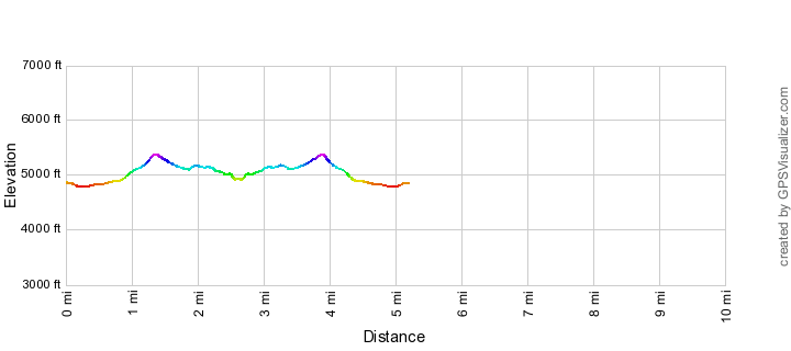
Gibbon Mountain
!!DO NOT attempt this unless you are comfortable with off-trail travel and navigation in the Santa Catalina Mountains!! Gibbon Mountain is an off-trail high point in the southern section of the Santa Catalina Mountains with nice ridges and great views (including a really great look down Bear Canyon). There are some faint trails in the area to make use of but this is certainly best considered an off-trail adventure.
- Gibbon Mountain is a well known high point but the required off-trail hiking is not for everyone… This is a classic – beautiful views, an off-trail challenge and solitude. In this area Airmen Peak is the more impressive peak, but it is also a much more rugged/strenuous adventure.
Gibbon Mountain Elevation Profile
Molino Basin Trail
The Molino Basin Trail is part of the Arizona Trail, an important connector trail and is used to get to the start of the popular Sycamore Reservior Trail.
- Within easy view of the highway in places this trail is surprisingly nice, but ultimately this trail has the most value as a connector rather than a destination.
Molino Basin Trail Elevation Profile
Point 4981 Above Hairpin Turn
An off-trail adventure out to a great viewpoint above the first sharp turn on the General Hitchcock Highway.
- Skip this unless you have explored all the other destinations listed on this page – this obscure point is listed here for real aficionados of the area who will enjoy the unique position of this point above Hairpin Turn and Soldier Canyon – the faint old trail may speed you on your way for part of the trip, but be prepared for off-trail travel and navigation…
Point 4981 Above Hairpin Turn Elevation Profile
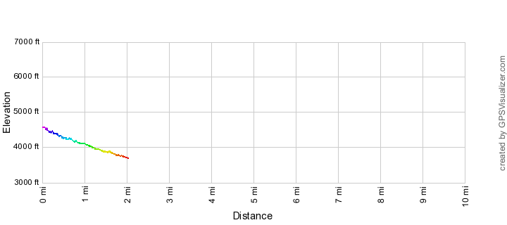
Soldier Trail
The Soldier Trail is the lowest official trail on the mountain. It climbs from the trailhead up to the Gordon Hirabayashi Recreation Site with some steep sections of climbing and good views of Soldier Canyon.
- An interesting mix of views and terrain – but it is probably most interesting if combined with a longer hike and a car shuttle.
Soldier Trail Elevation Profile
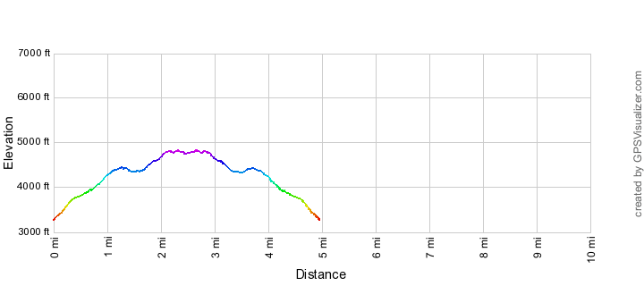
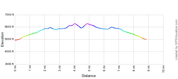
Sycamore Reservoir Trail
The Sycamore Reservoir Trail is a classic – up a wash to a great saddle, down to Bear Canyon and an old dam and out to great views of the inner basin of the Santa Catalina Mountains!
- This is a ‘must-do’ hike – variety, views, history and it is part of the Arizona Trail!
Sycamore Reservoir Trail Elevation Profile