The Greater Tucson Area has a number of access points on the edge of the city that lead into the Santa Catalina Mountains. These trails are generally quick to access from Tucson and start in the fascinating landscape of the Sonoran Desert – always a treat and certainly unique if you are visiting from out-of-town! (And if you have never been to the Sonoran Desert you should probably include a stop at the Arizona-Sonora Desert Museum – educational, interesting and well worth a visit!)
However, all of these hikes are at lower elevations where the Summer temperatures can be dangerously hot! None of these hikes will offer any relief from the heat and the landscape provides no significant shade to escape the sun.
At this point many of the Trailheads in the Greater Tucson Area are well established, but it would be a mistake to believe that we should not be constantly vigilant about maintaining and improving access to public lands – one organization in Pima County working to do this is the Pima Trails Association – consider supporting their work!
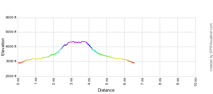
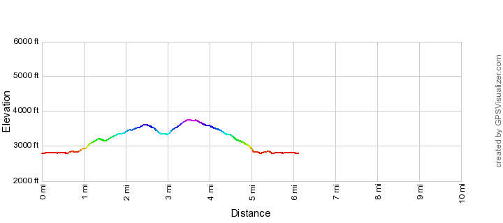
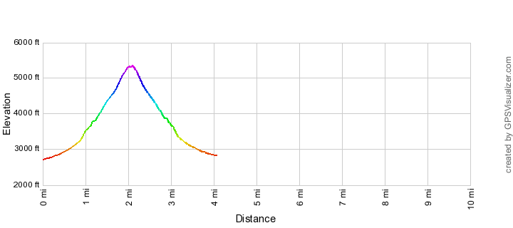
Agua Caliente Hill Trail
Agua Caliente Hill Trail is the high point between the Santa Catalina and Rincon Mountains – this hike climbs thru the desert, past Cat Track Tank and across open grassy hillsides on its way to the top.
- Great views and great sunsets – this ‘hill’ has more climbing than you might expect – about 3000′ – but is well worth the effort. A great winter destination.
Agua Caliente Hill Trail Elevation Profile
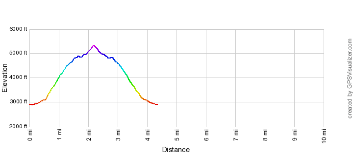
Blackett's Ridge
A strenuous hike to an amazing position on the ridge between Sabino Canyon and Bear Canyon – this hike is truly spectacular but the elevation gain makes this far from a casual stroll.
- Anyone with the fitness to do this hike should do it – this is a classic!
Blackett's Ridge Elevation Profile
La Milagrosa Trail
A beautiful desert hike that spends several miles on the ridge between La Milagrosa and Agua Caliente Canyons.
- The first part of this hike (thru a neighborhood) is not ideal and there are often views of Tucson, houses or the highway from the trail that take away from any sense of escaping into the wilderness… But this desert hike between granite canyons is unique this is a great hike.
La Milagrosa Trail Elevation Profile
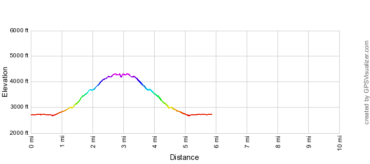
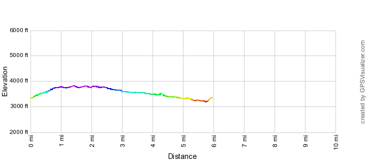
La Milagrosa and Agua Caliente Canyon Trail Loop
A nice tour of this area that crosses two amazing canyons and offers great views from the ridges and grassy hillsides.
- This great loop takes in the best of this area and includes desert, canyons and ridges! (And is shorter and less strenuous than an ascent of Agua Caliente Hill Trail!)
La Milagrosa and Agua Caliente Canyon Trail Loop Elevation Profile
Miner's Pool
Sabino Canyon is one of the most impressive canyons in the Tucson area and there are some amazing stretches of canyon between the end of the Sabino Canyon Trail and the road. This hike is largely off-trail – don’t let it’s apparent proximity to established trails and lack of elevation change fool you, this is an extremely rugged area and may require scrambling on wet slippery rocks, swims in very cold water, route finding puzzles among huge boulders, flash flood danger and more…
- Probably only a real attraction for hikers who love the Santa Catalina Mountains and want something a bit off the beaten path – hiking into the canyon from the from the paved road up Sabino Canyon is probably the sweet spot for enjoying the canyon in hot weather…
Miner's Pool Elevation Profile
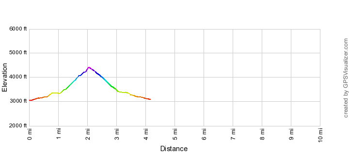
Pontatoc Ridge Trail
A steep ridge hike with excellent views of the steep cliffs above and Tucson below. This trail ends at an interesting position high above Pontatoc Canyon and below huge cliffs there are several good places to stop on the way up making this a interesting destination for a shorter hike.
- With several interesting stopping spots this is a steep and rewarding hike even if you don’t make it to the end (and a great workout!). The ending of this trail beautiful but not as classic as Blackett’s Ridge…
Pontatoc Ridge Trail Elevation Profile
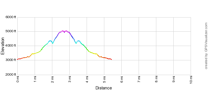
Pontatoc Ridge
!!The end of this route is not and official trail and is closed from Jan. 1 to April 30 because of Bighorn Sheep Management Area Restrictions!! The official Pontatoc Ridge Trail takes you to a spectacular spot – but if you are comfortable traveling off-trail (be careful, know your own abilities and don’t underestimate the Santa Catalina Mountains!) an unofficial route branches off the Pontatoc Ridge Trail and takes you to the top of the Cliffs!
- The steep/loose unofficial route to top is not for everyone – if in doubt don’t attempt this and only try this if you feel confident with off-trail travel in the Santa Catalina Mountains – but if have the skills to make this hike it is a classic! Not quite as spectacular at the top as Blackett’s Ridge but it also has less traffic at the top and some short stretches along the ridge that are unbeatable.
Pontatoc Ridge Elevation Profile

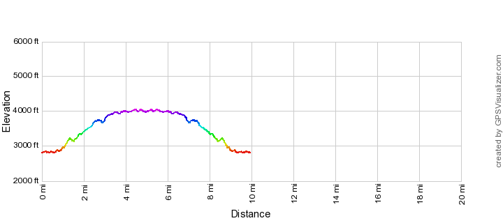
Pontatoc Canyon Trail
At the hillside junction of the Pontatoc Canyon and Pontatoc Ridge Trails you might assume that the canyon trail would be the ‘easier’ option – but you would be wrong! The Pontatoc Canyon trail climbs steeply on the hillsides above Pontatoc Canyon occasionally crossing the canyon.
- This trail doesn’t disappoint for a great workout, if there is good water flow in Pontatoc Canyon the last crossings before the end of the trail can be spectacular and there are beautiful moments – but this is low on the list of trails I generally recommend (I would guess that the hikers who would most enjoy this trail have probably done many of the hikes in the area and don’t really need a recommendation of where to go…)
Pontatoc Canyon Trail Elevation Profile
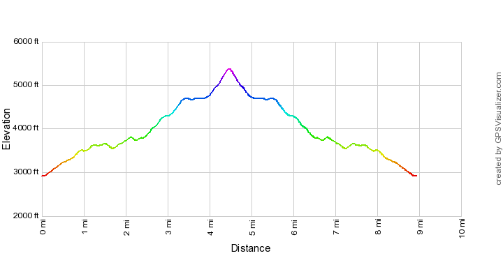
Pusch Peak Northwest Side Route
Pusch Peak is an iconic peak close to Tucson that forms the southwest corner of the Santa Catalina Mountains. There is not an official route to the top but this route is well worn and commonly used. !!Caution: This is a well traveled but unofficial trail, you should be comfortable with off-trail travel and navigation in the Santa Catalina Mountains before attempting this. Also note that this route and (Pusch Peak) are closed from Jan. 1 to April 30 for the Bighorn Sheep lambing season.!!
- While somewhat steep, loose and unofficial this is a fantastic hike and certainly a Tucson classic – best done when the weather is cool in Tucson – late fall/winter/early spring).
Pusch Peak Northwest Side Route Elevation Profile
Pusch Peak Southeast Ridge Route
The Pusch Peak Northwest Side Route is certainly a classic with great views and a great destinations, but it turns out that if you are will to get off the beaten path and leave any hint of trails behind there is an off-trail route that ascends to Pusch Peak from the Pima Canyon Trailhead along a route that I find much more aesthetic. !!Caution: This is seldom traveled off-trail route – you should be comfortable with off-trail travel and navigation in the Santa Catalina Mountains before attempting this. Also note that this route and (Pusch Peak) are closed from Jan. 1 to April 30 for the Bighorn Sheep lambing season.!!
- This will never be a popular classic – it requires off-trail travel and not everyone enjoys a day filled with shin-daggers and brush – but if you don’t mind being off-trail walking the ridges to the top is so much more lovely than Pusch Peak Northwest Side Route!
Pusch Peak Southeast Ridge Route Elevation Profile
Rosewood Point
!!CAUTION: This hike is off-trail, know your limits and do not attempt this unless you are comfortable with off-trail hiking and navigation in the Santa Catalina Mountains – in addition this peak and the off-trail portion of this hike is close from Jan. 1 to April 30 each year for the Bighorn Sheep lambing season!! Not as high or dramatic as the peaks to the west on Pusch Ridge Rosewood Point is a slightly more mellow offtrail journey to a great viewpoint.
- For classic Tucson off-trail hikes with dramatic views look at other destination on Pusch Ridge like Pusch Peak and Table Mountain – but if you have done those and want to escape the crowds Rosewood Point might be just the hike!
Rosewood Point Elevation Profile