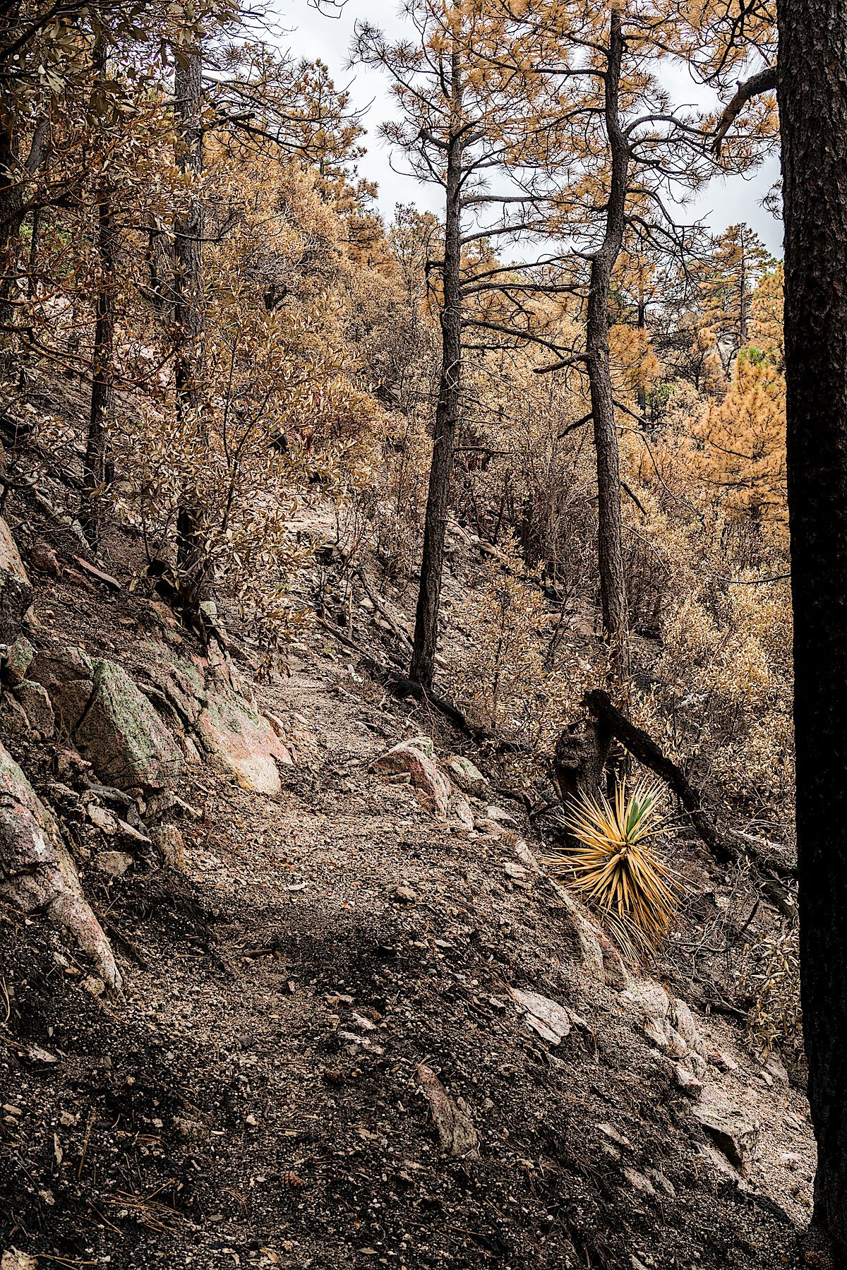
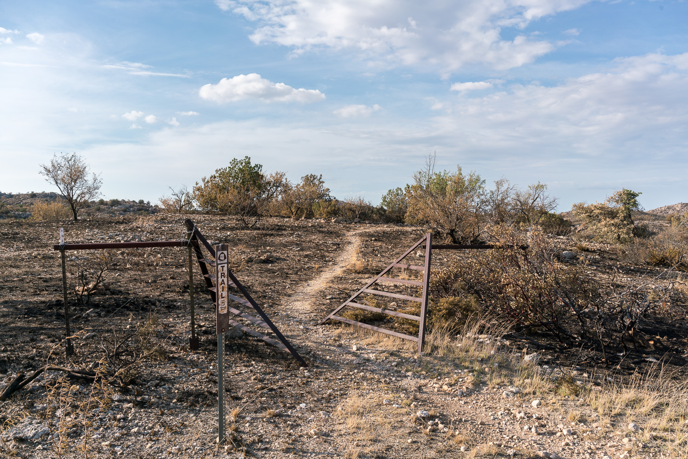
Entering the Burro Fire burn on the Guthrie Mountain Trail. July 2017.
On the Green Mountain Trail it was hard to tell what I would find – the Green Mountain Trail was untouched by the Burro Fire, but not far from Bear Saddle on the Guthrie Mountain Trail the impact of the Burro Fire became obvious.
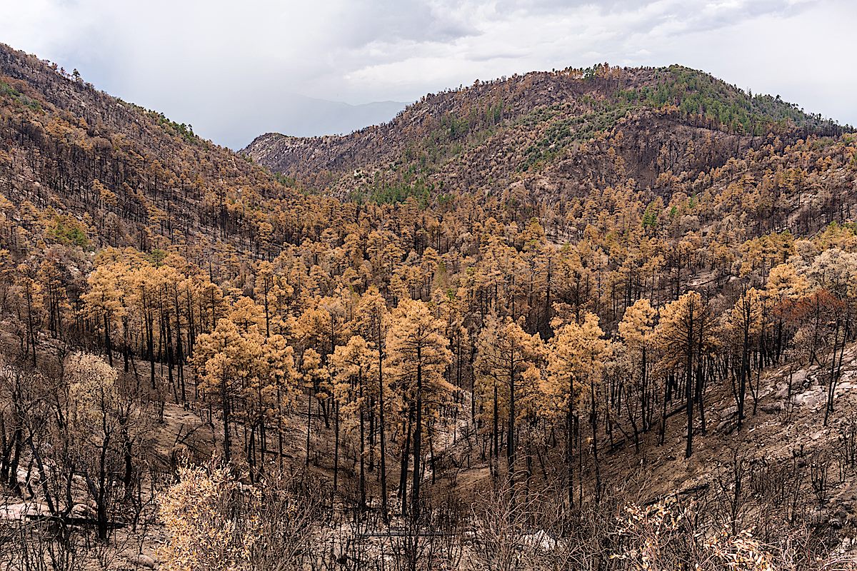
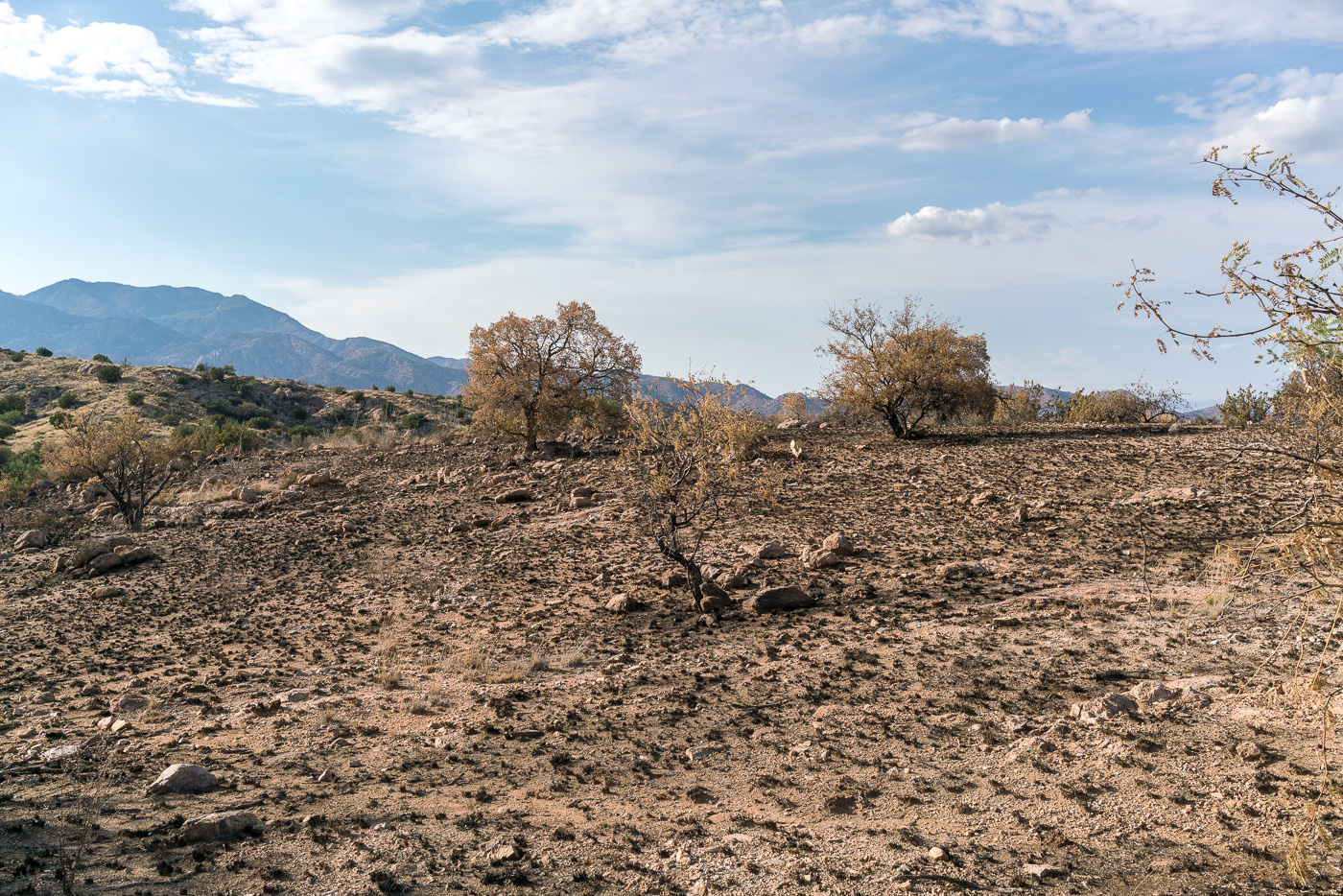
Brown trees below and on the slopes of Guthrie Mountain. July 2017.
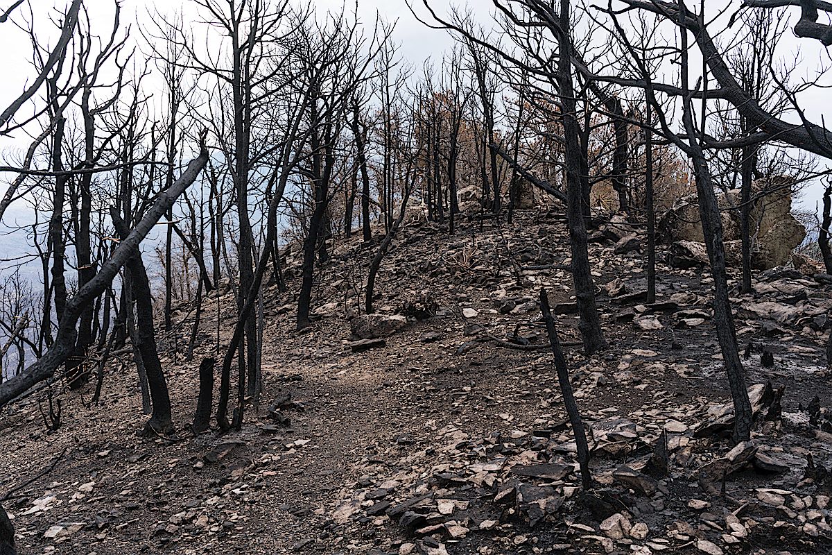
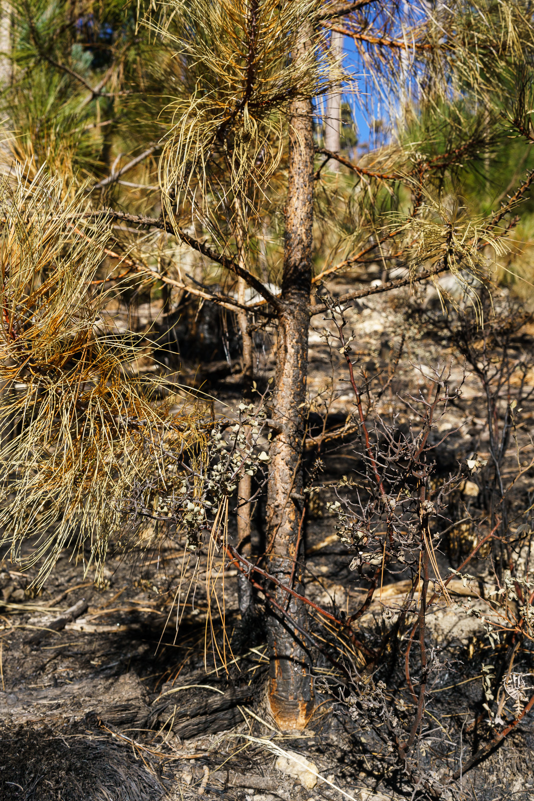
On the ridge out to the short rocky climb before the summit the trees scorched by the fire seemed almost like strange fall colors – but the summit must have burned hotter, here the trees have been transformed into black sticks.
The summit of Guthrie Mountain a few weeks after the Burro Fire. July 2017.
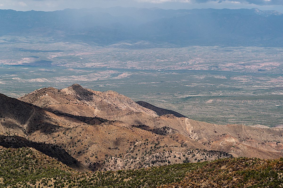
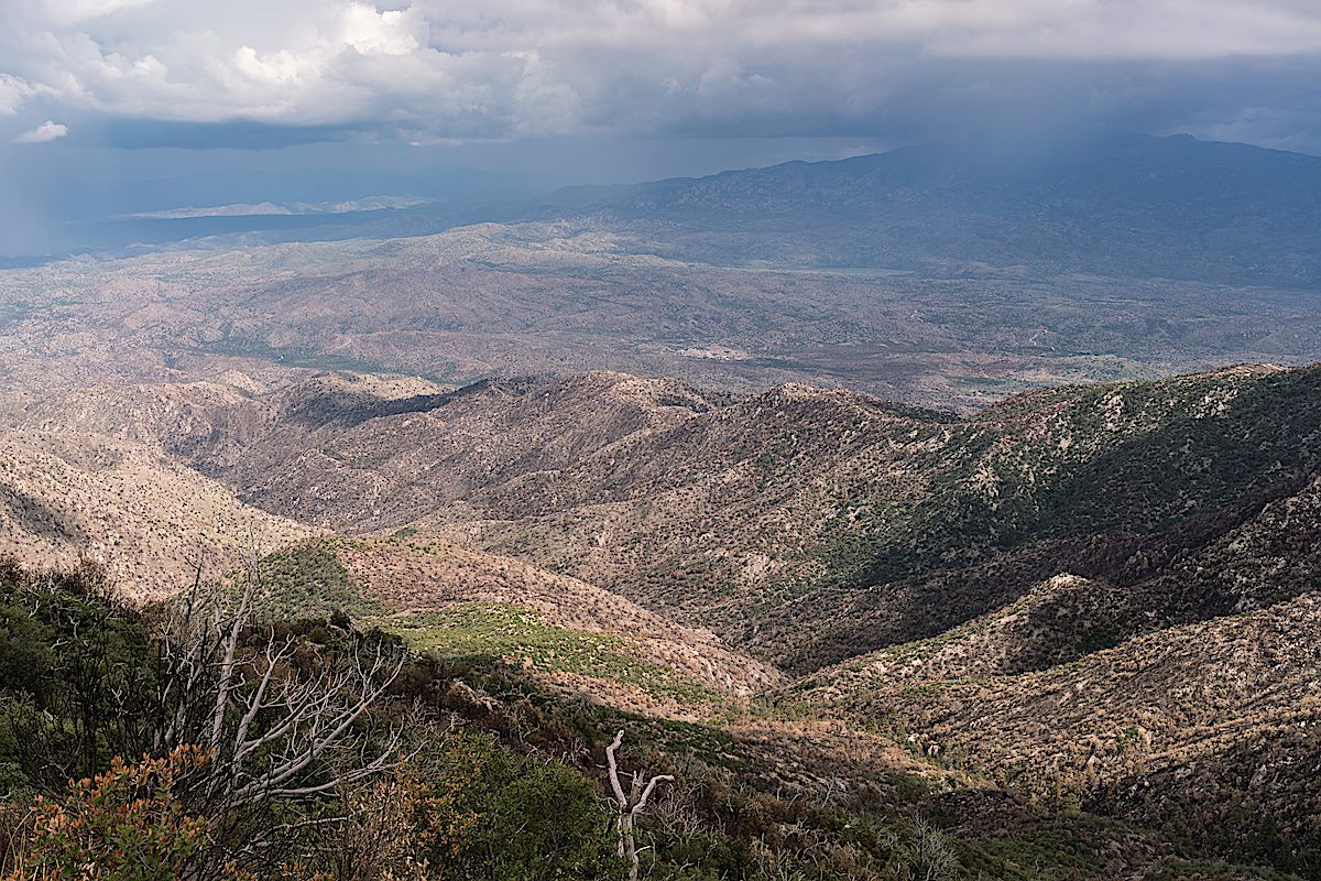
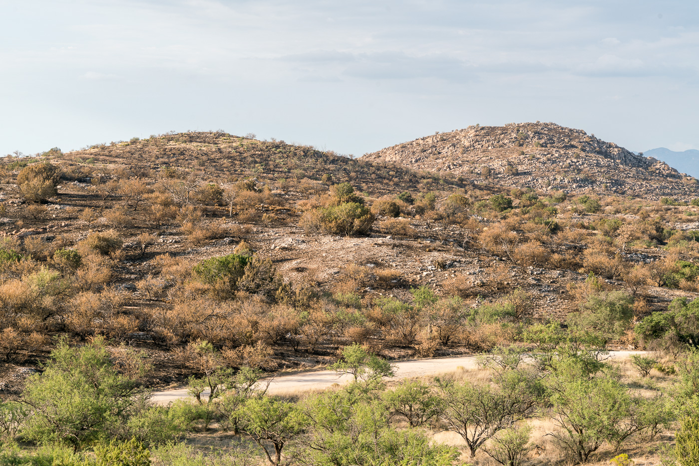
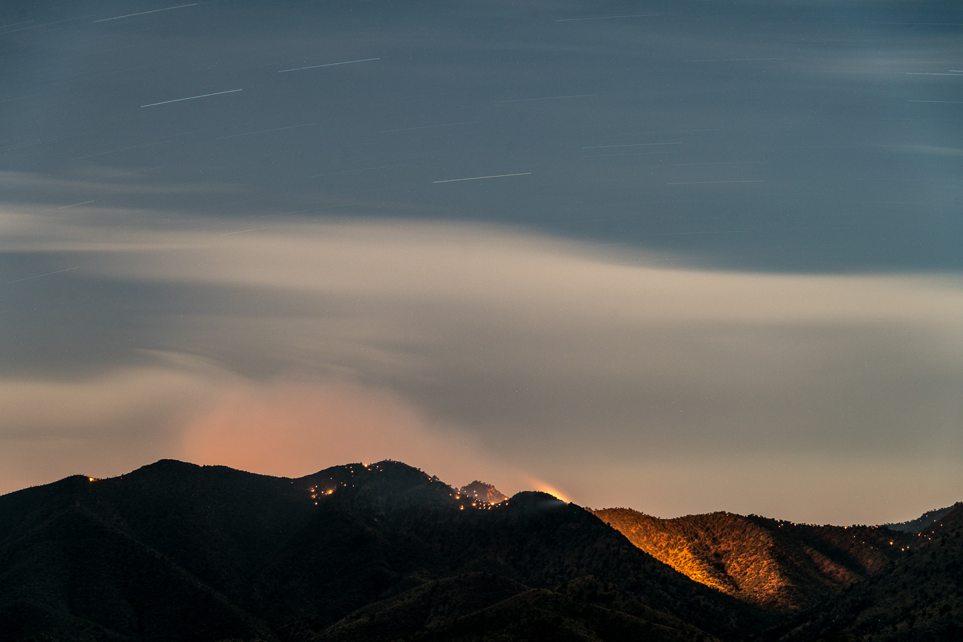
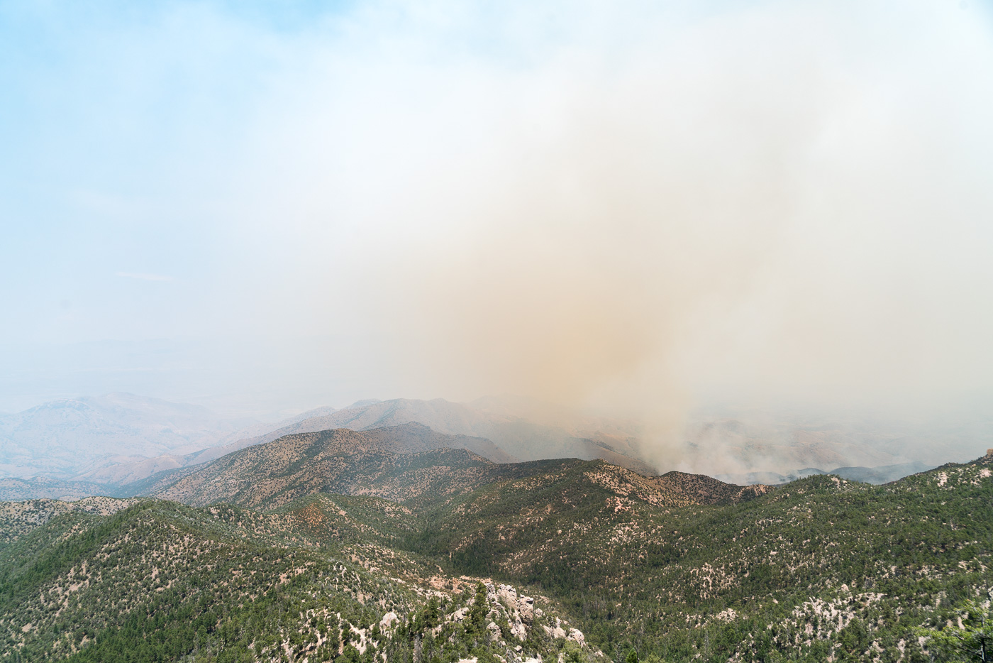
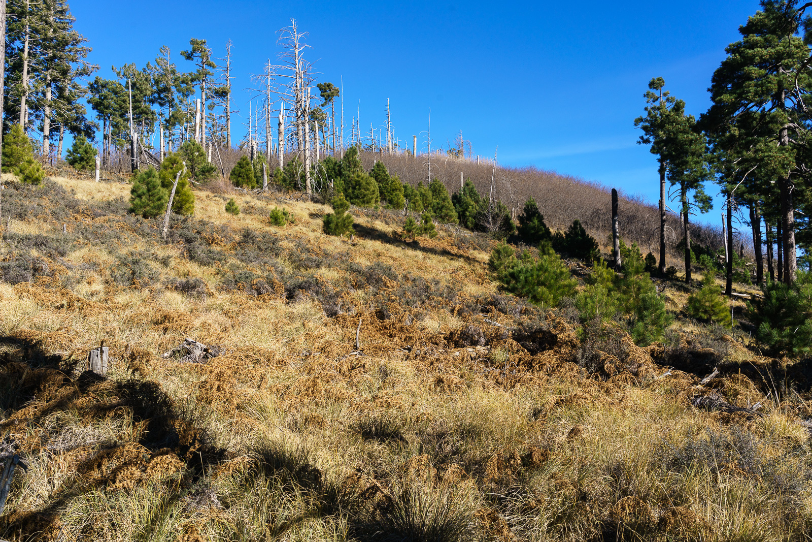
With the trees and brush largely cleared by the fire it is now easy to wander down from the summit for more photos – other areas burned in the Burro Fire attract my attention today – the slopes of Evans mountain and Burro Creek are distinctly brown.
Evans Mountain – the Burro Fire was stopped at Edgar Canyon on the other side of this ridge. July 2017.Looking down from the slopes of Guthrie Mountain on Burro Creek – also burned in the Burro Fire. July 2017.
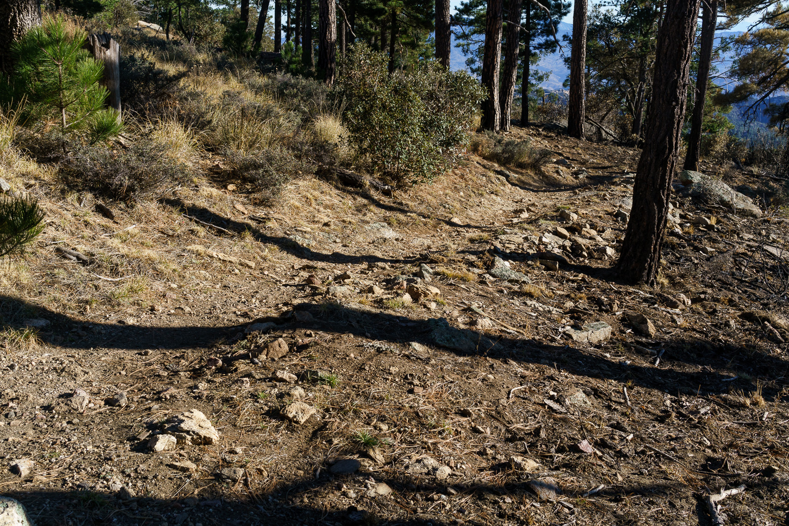
Guthrie Mountain is still very much worth visiting – I was a bit stunned at first by the new look of the summit, but the burned slopes are already spouting new growth and it will be interesting to see what happens as the area comes back to life.
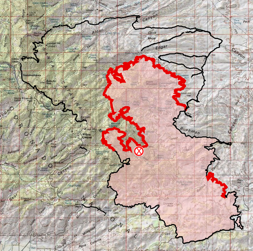
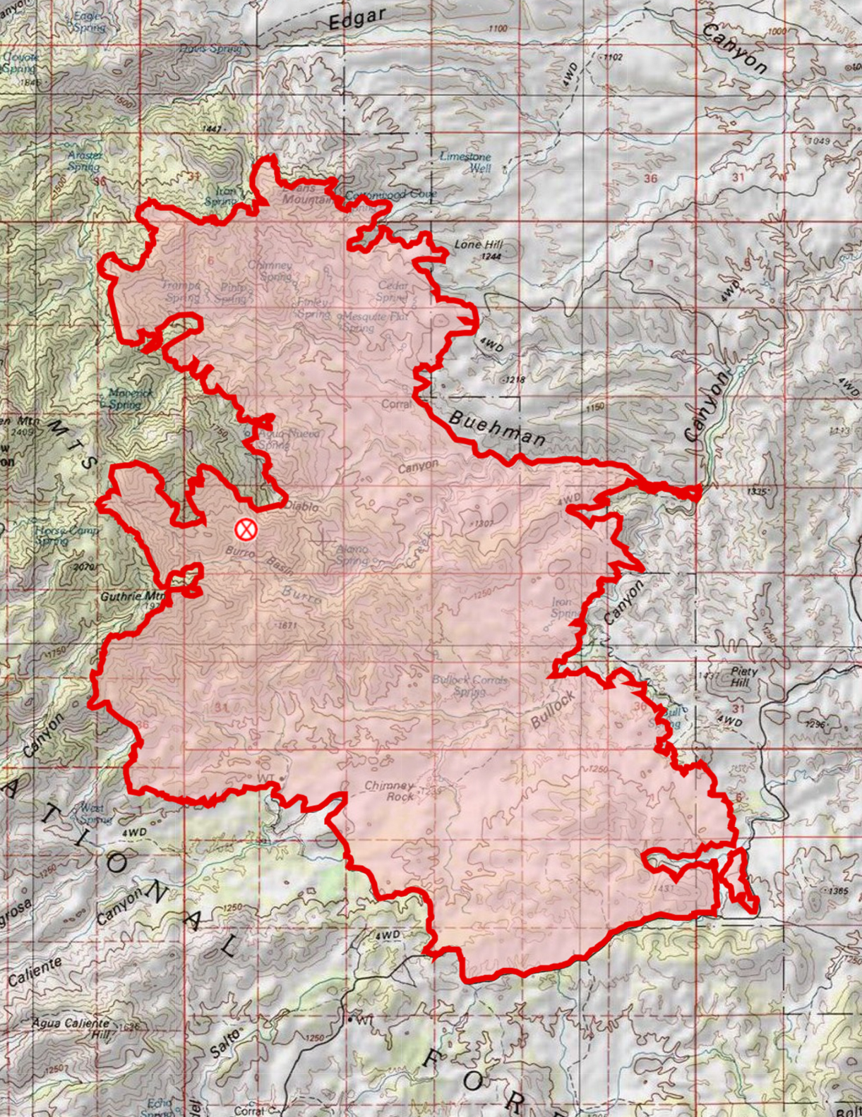
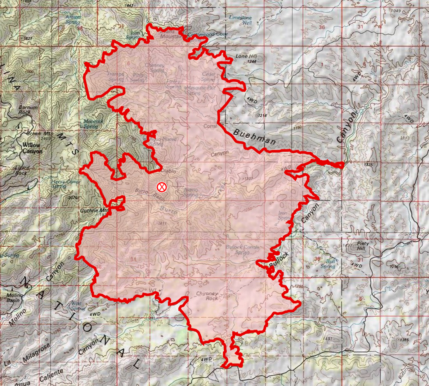
The Burro Fire started on June 30th near Burro Tank in the Redington Pass area – the fire burned 27,238 acres.
Final Update
On 7/13/2017 a final update was issued on Inciweb – the mountain will re-open on 7/14 8am and and all closures will be lifted so that all trails/trailheads on the mountain will be open!! The final size of the fire is estimated at 27,238 acres. The containment is listed at 95% (there is a small area on the NW side of the fire that on the last map still has active perimeter marked). The cause is still listed as ‘Under Investigation’.
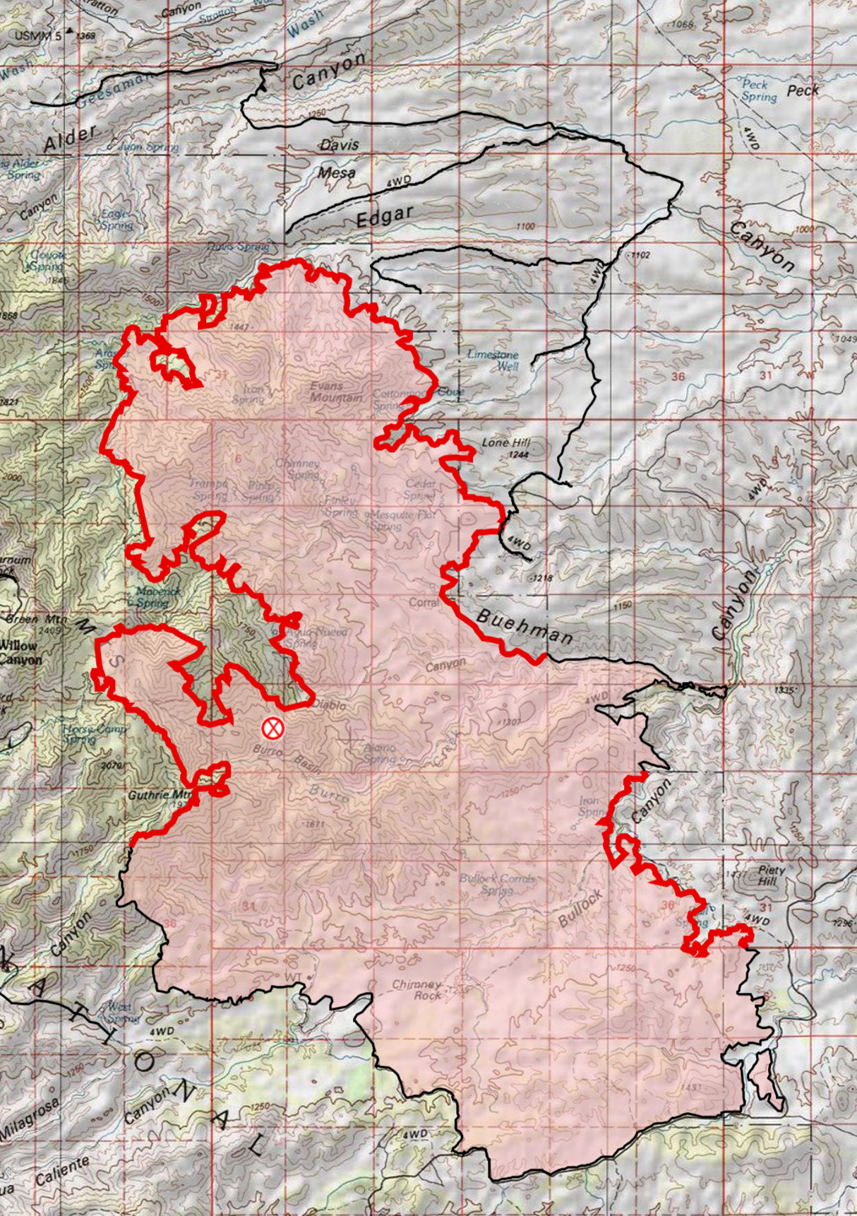
On 7-11-2017 a revised closure order was issued ahead of the anticipated opening of the highway up the mountain to the general public on Friday. July 2017.Burro Fire – 7/12/2017 8AM – At 74% containment the only active perimeter remaining is on the NW side of the fire. July 2017.
7/11/2017
Evening: I drove Redington Road to Piety Hill to get a quick look at the impacts of the fire and fire fighting. Close to the road in the burned areas I could see the grass was gone, some or many trees were still standing and in some spots green vegetation was still visible. There were ridges in the distance that looked like they burned hotter – and near the road some of I saw was probably controlled burning by fire crews – but thankfully, at least near the road, the landscape was not a desolate moonscape!
Off Redington Road grass and underbrush were clearly burned but many trees remained. July 2017.The Burro Fire was stopped at Redington Road and in this view you can see the green vegetation south of the road and burned area north of the road. July 2017.The start of the Bellota Trail – part of the Arizona Trail – at the Italian Spring Trailhead. July 2017.
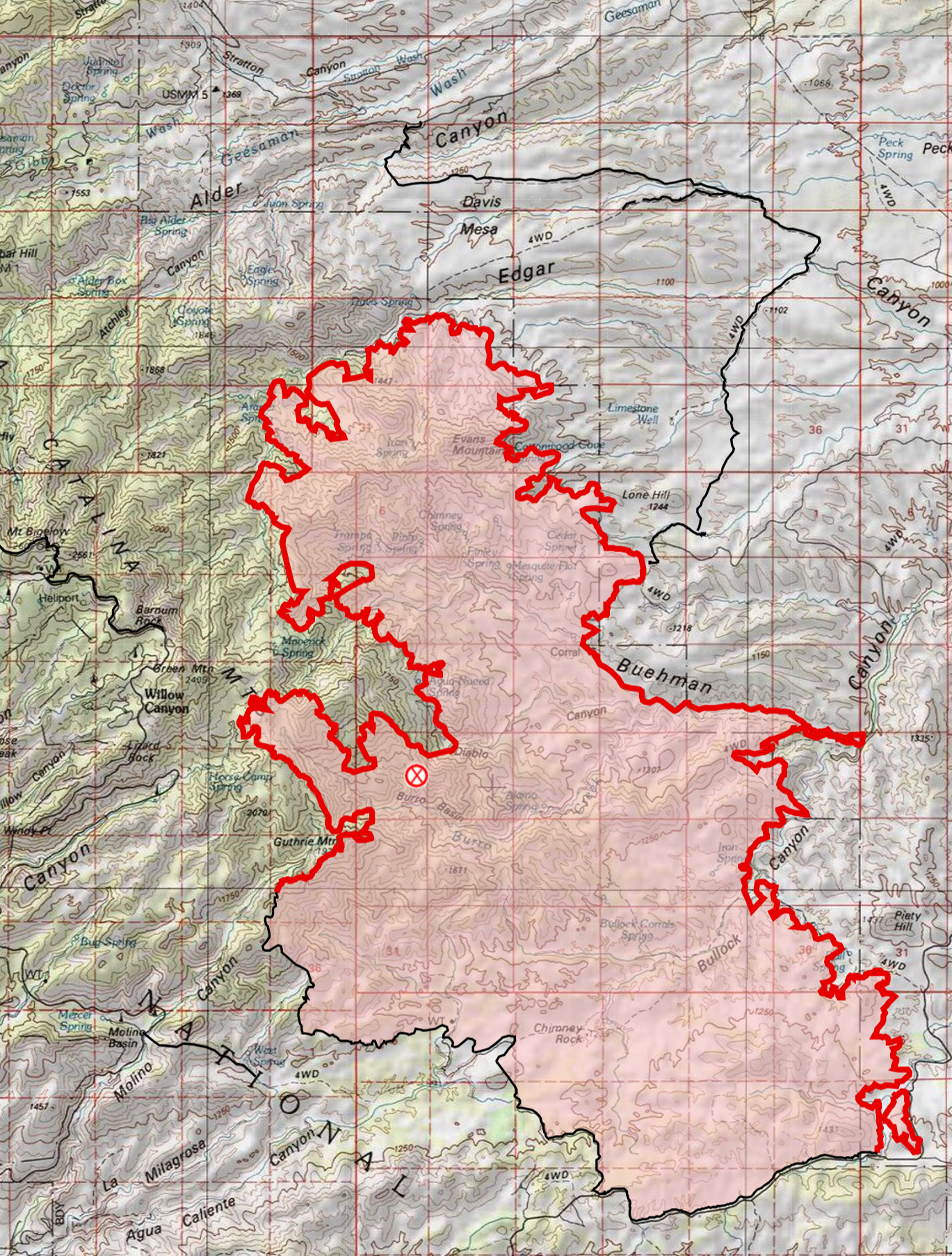
6:40 AM: Yesterday evening 65% containment was announced – and perhaps more telling about the state of the fire residents, business owners and business employees were allowed back up the mountain starting at 3pm yesterday and at this time no additional community meetings are scheduled! (The incident commander, Bea Day, did not give any estimate on when the mountain would be open to the general public.) Redington Road is now open to all traffic. The fire is listed at 27,238 acres. The current map reflects the increased containment with more of perimeter marked as contained on every side of the fire! Rain again last night should help dampen the fire and increase containment (Green Mountain, Dan Saddle and Redington gauges all show rain in the last day on the Pima County ALERT map).
Burro Fire -7/11/2017 6:39AM – the map reflects the 65% containment announced yesterday!. July 2017.
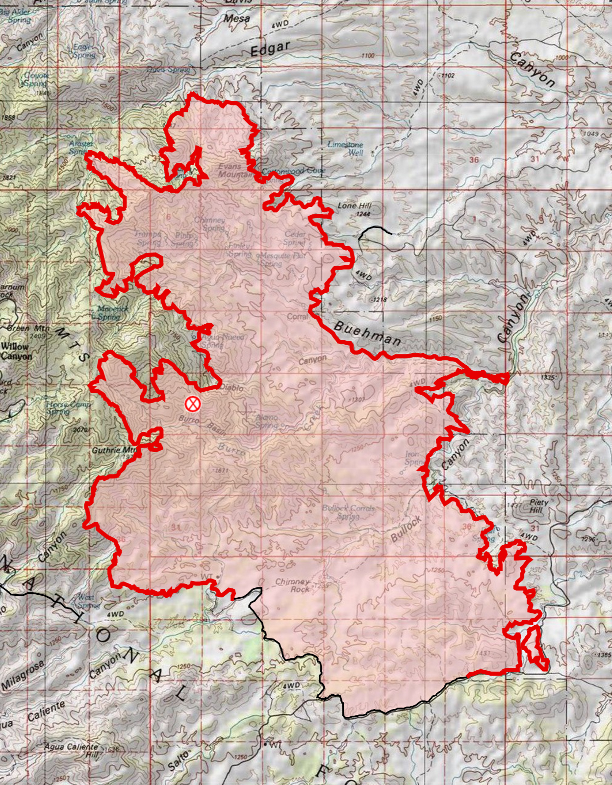
7:38 AM: 27,266 Acres, 51% Contained. Fire crews finished prepping the Control Road yesterday and added more dirt road/dozer lines to the map – the extensive circle of preparations can be seen on the map! Fire growth in Edgar Canyon was minimal even though hot/rugged conditions meant that there were not crews in the Peck Basin area yesterday – the fire continues a slow spread to the east, with hot conditions limiting crews on the ground and established lines to the east the fire is being allowed to grow in that direction for now. Progress was made containing the fire in the Piety Hill, Buehman Canyon and Guthrie Mountain areas.
7/9/2017 7AM – Burro Fire – minimal fire growth and additional containment!. July 2017.
7:40 AM: Inciweb was updated this AM to report 26,731 acres burned and 36% containment. Fire growth shown on the map this AM is modest. Fire crews with air support have been able to stop the fire at Edgar Canyon and prevent the fire from moving west into the Peck Basin area – east of this area the map now shows a much more extensive set of fire lines surrounding the fire. The southeast portion of the fire has quite a bit less active fire perimeter with area near Buehman Canyon and Piety Hill now shown in black.
Burro Fire – 7/8 AM Map – compared to the 7/7 AM map there are additional fire lines on the north and east side of the fire with only modest additional areas burning on the north and west sides. July 2017.
5:30 PM: At the community meeting they just announced 36% containment. There is a news article below about two injured firefighters – at the meeting there was a question about the injuries and it was mentioned that they were minor and the firefighters were back at work.
7:20 AM: Inciweb lists the Burro Fire at 25,355 acres and 19% contained. Compared to yesterday note the growth in the Edgar Canyon/Peck Basin area – this area was mentioned multiple times in the Community Meeting last night in part because of the concern that the fire could burn up from this area towards the highway. The map this AM also adds a substantial number of firelines compared to yesterday AM. The southwest side of the fire is now contained. On the west side preparations to hold the fire at the highway have been made including plans for burnouts if needed. On the east side a line has been established from Black Hills Mine Road, across Alder Canyon at Ventana Windmill, out Davis Mesa, across Edgar Canyon down to Lone Hill and then towards the Brush Corral Area (Black Hills Mine Road connects to the Control Road which has been mentioned as a feature that could be used to control the fire – if this line + the Control Road + the highway was held it would encircle a large section of the fire).
7/7/2017 6:50 AM – Burro Fire Map – compared to Thursday AM there has been growth in the Edgar Canyon/Peck Basin area and a substantial number of fire lines added. July 2017.
7:30 AM: The Burro Fire is currently listed as 24,547 acres with 11% containment. The map as of this AM shows the south side of the fire – along Redington Road – as contained. Since yesterday AM the northern section of the fire has grown and is burning down towards Edgar Canyon.
AM Map from July 5th – on the NE side the fire has burned down towards Edgar Canyon, on the south side there is now a significant stretch of fire line that is no longer marked as active. July 2017.
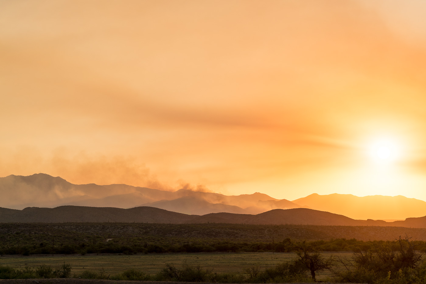
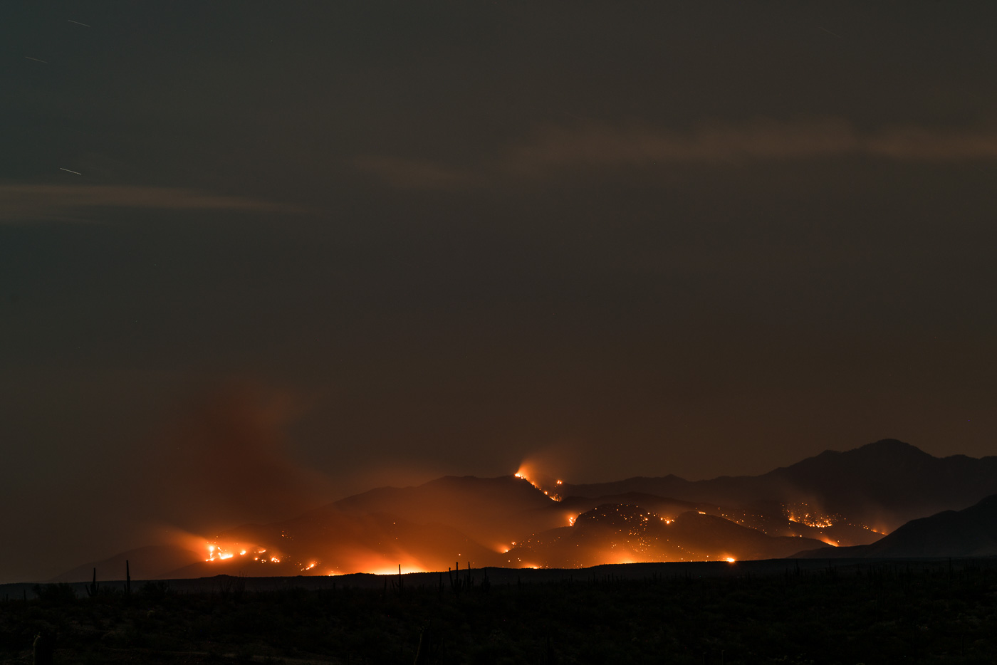
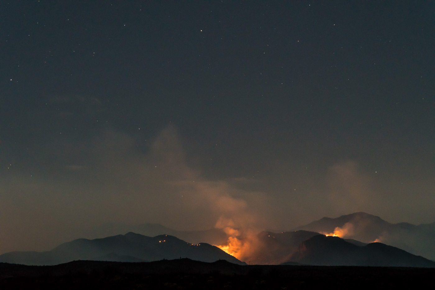
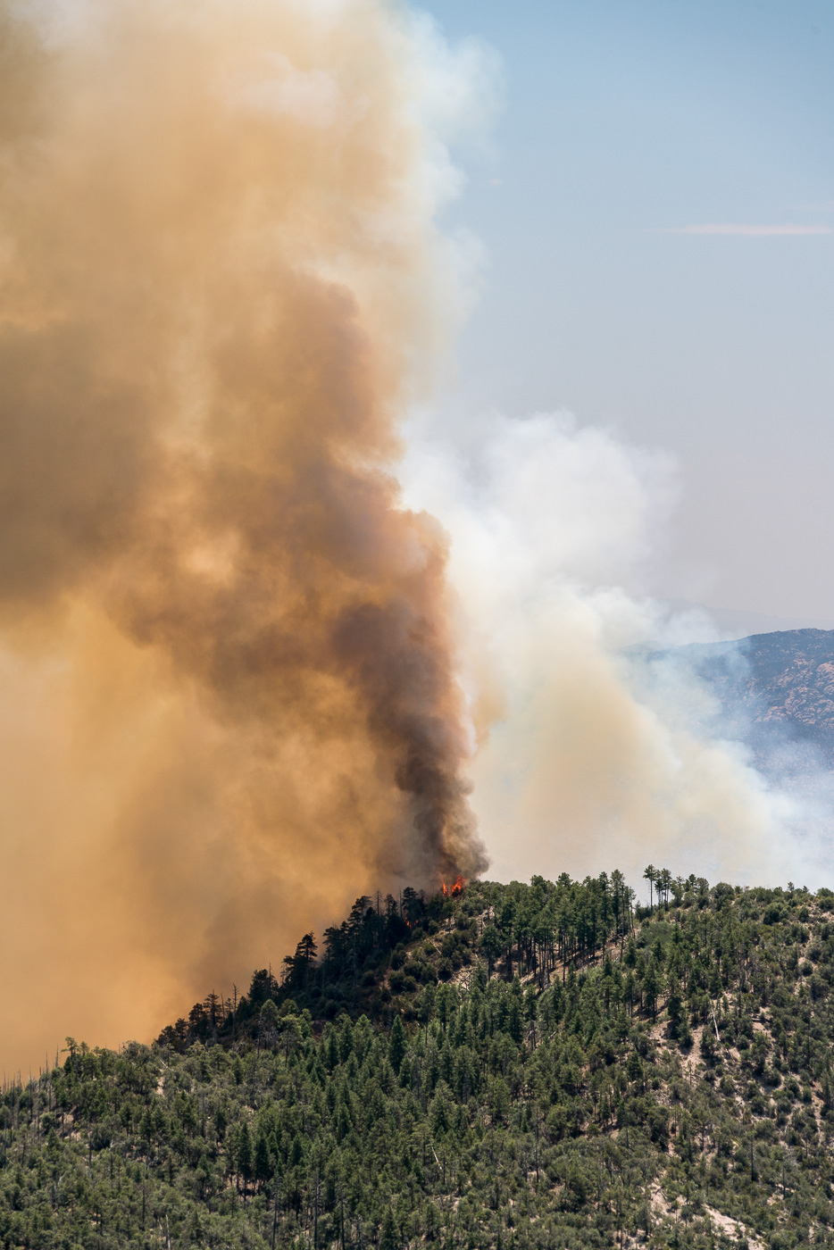
Evening/Night: Driving north from Benson the fire came into view well before the junction with Redington Road – sun, smoke and fire created several amazing views from the road. Black Hills Mine road is now closed – but with Evans mountain and the slopes down into Edgar Canyon burning the fire was easy to see from Redington Road after it climbs away from the San Pedro. The evening update puts the fire at 24,547 acres 11% contained.
Sun and Smoke from Cascabel Road. July 2017.The Burro Fire from Cascabel Road. July 2017.Evans Mountain and the slopes below burning in the Burro Fire on the night of the 5th. July 2017.
Today, firefighters strengthened control lines along the Redington Pass Road and after cold trailing and mop up of the line, declared that this section of fire perimeter is now contained. Tonight, engines will patrol the area and extinguish hot spots as needed. No additional fire growth is expected in this area.
Prep work along the Catalina Highway is nearing completion. Fire crews have reinforced Firewise mitigations put in place by residents and have set up contingency fire lines as a defensive measure. Crews are prepared to initiate burning operations in front of the fire, should it move westward, threatening structures and other values at risk.
Tonight crews will be patrolling the south eastern perimeter of the fire. Winds are predominately coming from the southeast, pushing the fire back onto itself.
The northeastern side of the fire will be monitored through the night. Incident Fire Behavior Analysts do not anticipate any substantial fire spread in this area over night.
The most active fire behavior on the Burro Fire was observed on the northwestern perimeter. In this section the fire has dropped into canyons where the vegetation is predominantly grass and scrub. Helicopters and fixed wing aircraft were used to impede the fires progress. Under current weather conditions, these canyons are in alignment with the wind, so that fire has the ability to move quickly through the light flashy fuels.
7:10 AM: Inciweb was updated this AM to list the fire at 21k acres – several notes from the update:
There will be a Community Meeting 5:30 p.m., Wednesday July 5, 2017, at the Sahuaro High School, 545 N. Camino Seco, Tucson, AZ 85710. American Sign Language (ASL) and Communication Access Real-Time Translation (CART) captioning will be provided. The meeting will be live streamed on Facebook https://www.facebook.com/BurroFireInfo/
Fire crews continued patrolling and preparing homes and other structures along the Catalina Highway. They also surveyed the terrain between the fire’s western edge and the highway to determine locations where defensive measures might be taken should the fire encroach upon the roadway.
With the support of heavy helicopters and fixed wing aircraft, fire crews built fire line along the southern and eastern flanks of the fire to protect infrastructure as well as cultural and recreational values, and were able to hold the fire north of Redington Pass Road. Despite dry conditions, high heat and outflow winds, firefighters were able to successfully protect ranch buildings in those areas. To date, the suppression efforts have ensured that no structures have been burned.
The terrain on the north eastern side of the fire is rugged and mountainous. No roads exist that would provide access for fire apparatus. Given the topography and lack of access, the decision has been made to rely mainly on air resources to slow the fire’s progress in this area. Contingency plans are in place, should fire activity become a threat to infrastructure as well as cultural and recreational values.
In the maps this AM I noticed two interesting details:
The satellite information on the fire suggests that the fire has made notable progress over the Evans Mountain area and is much closer to Edgar Canyon and Peck Basin.
The maps reflect the note above about holding the fire north of Redington Road – the fire perimeter on the south-east now runs along Redington Road.
Satellite information suggests that the fire has made significant progress over Evans Mountain and towards Edgar Canyon and Peck Basin. July 2017.Burro Fire Map 7/5/2016. July 2017.
Inciweb currently lists the fire at 14,112 acres although more notably the maps from the AM show quite a bit of movement to the south. From Inciweb:
Beginning July 4, Burro Fire Public Information Officers will provide media briefings at 7am and 7pm daily at the Incident Command Post at Sabino High School, 5000 Bowes Road, Tucson Arizona.
The Coronado National Forest has now implemented forest closures from Redington Pass Road and the National Scenic Trail north including Catalina Highway and the Control Rd. to the Pima/Pinal County line. These closures can be found athttps://www.fs.usda.gov/coronado/
Burro Fire Map 7/4 7:25 AM – since yesterday there has been considerable growth to the south. July 2017.Burro Fire Topo Map from 7/4 7:25 AM. July 2017.
7/3/2017
Evening/Night: With the Control Road and Highway up the mountain both closed I drove around the north end of the mountain and took Black Hills Mine Road out to the edge of Alder Canyon – this didn’t give me a view of the more active south side of the fire, but it did let me watch as flames and smoke rose from the Evans Mountain area. For the most part the fire stayed behind the ridge – but as night fell all of the small hot spots, hidden in the days, became visible… From Inciweb:
Firefighters made good progress on the Burro Fire. Indirect line construction and structural protection continued to be the focus along the Catalina (Mt. Lemmon) Highway. On the south side of the fire, firefighters continued preparation along the Redington Pass Road. Natural barriers are also being used to aid in suppression efforts. Airtankers and helicopters were used to help delay the fire’s spread where they could be used safely and effectively. With extreme temperatures, we expect to continue to have periods in the afternoons when it’s too hot to fly.
Today’s fire spread was primarily in the southern area of the fire. Firefighters provided structural protection at the Bellota Ranch.
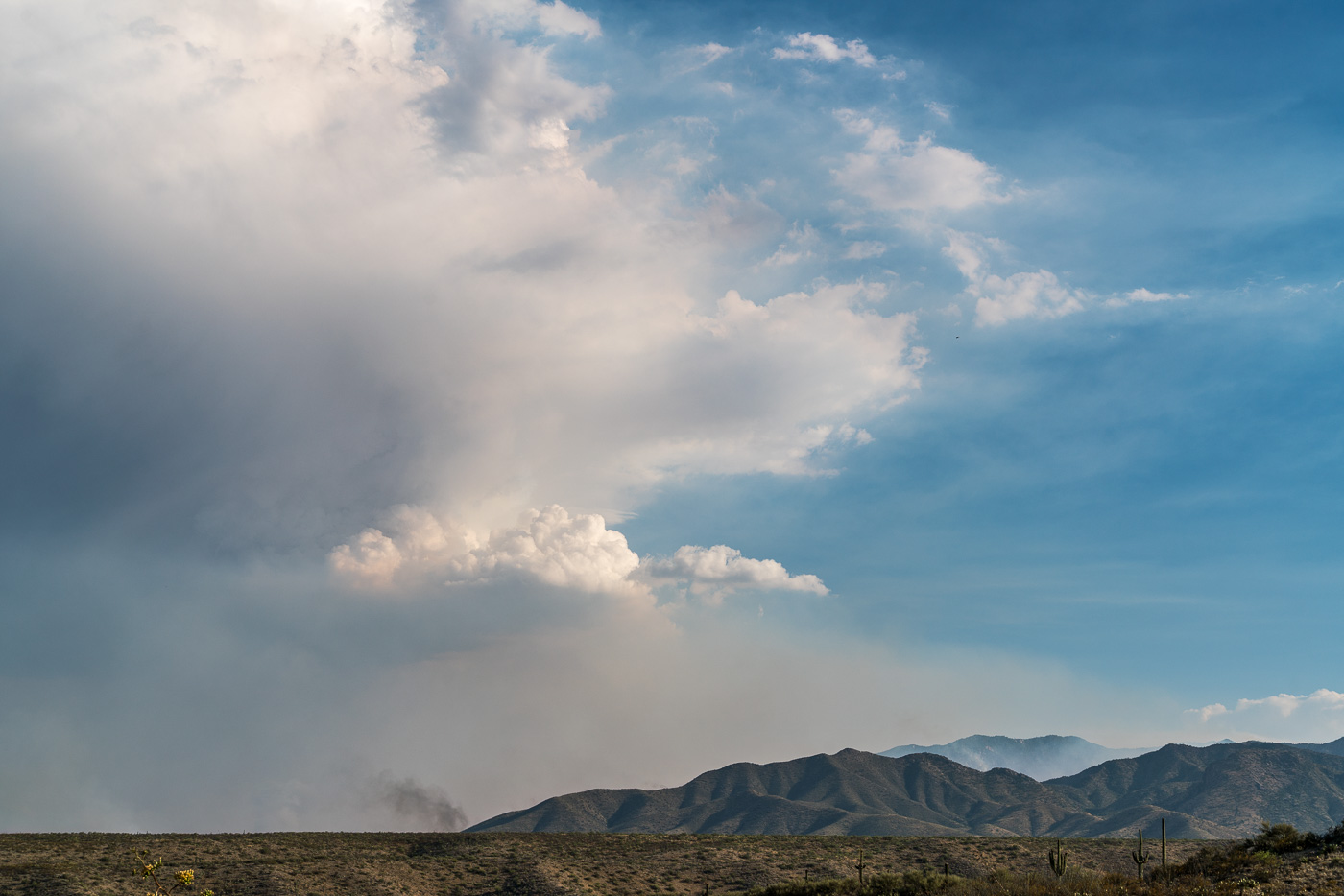
Smoke and clouds over the Evans Mountain Area. July 2017.A plume of smoke east of the Evans Mountain area with Piety Hill on the left. July 2017.Burro Fire – Evans Mountain. July 2017.Burro Fire in the Evans Mountain Area with Green Mountain in the background – from Black Hills Mine Road. July 2017.
There will be a Burro Fire Community meeting tonight, July 3, 5:30 p.m. at the Sahuaro High School (545 North Camino Seco, Tucson AZ). Please park in the main parking lot the meeting will be in the auditorium. The meeting will be live streamed on Facebook https://www.facebook.com/BurroFireInfo/. You must have an account to view the stream live. Following the meeting the recording will be posted, this will not require an account to view.
Firefighters are actively working to fully suppress the Burro Fire. Due the steep, rugged, inaccessible terrain and fire activity, firefighters are currently using indirect tactics. On the west side of the road, firefighters are planning and implementing structure protection along Catalina Highway. On the south side of the fire, firefighters are scouting and planning for preparation on holding the Redington Road. Airtankers and helicopters are being used to help delay the fire’s spread where they can be used safely and effectively. With extreme temperatures, we expect to continue to have periods in the afternoons when it’s too hot to fly.
There are currently 185 personnel working on the fire. Current resources include three hand crews, 14 engines, one water tender, and three helicopters.
6:30 AM: Evacuations have been extended – evacuations in Summerhaven were scheduled to start at 6am this morning. Inciweb now lists the fire at 14,000 acres – up from 5,000 listed yesterday. In the map below from the The National Wildfire Coordinating Group (NWCG) it appears that the movement on the north side of the fire has been considerable – the fire has burned across Buehman Canyon and certainly looks like it will burn thru the Evans Mountain area. From Inciweb planned actions: “Assess options for indirect line construction and containment using natural barriers. Assess needs for point protection at threatened infrastructure/communities.”
National Wildfire Coordinating Group (NWCG) Map – 7/3/2017 6:17am. July 2017.
7/2/2017
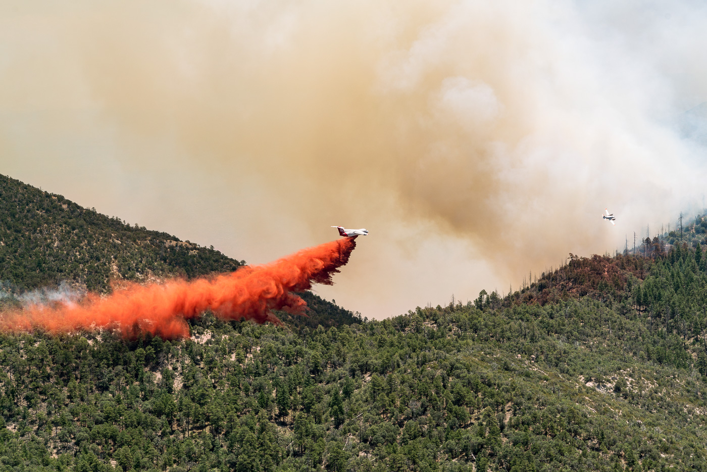
In the AM driving up the mountain the usual traffic was out on the road, you could barely smell the smoke and lower down on the mountain you had to look in the right direction to even know there was a fire. Higher on the mountain the smoke became more and more obvious… I hiked out to several points below Green Mountain to watch the fire – the smoke was impressive, scary, and larger than I expected. I watched cautiously for an hour or so as flames came up onto a ridge near Guthrie Mountain and aircraft dropped fire retardant to try to keep it in the canyon… Driving down the mountain I noticed fire personnel coming down and at the base Police had started to turn away anyone who was not a resident.
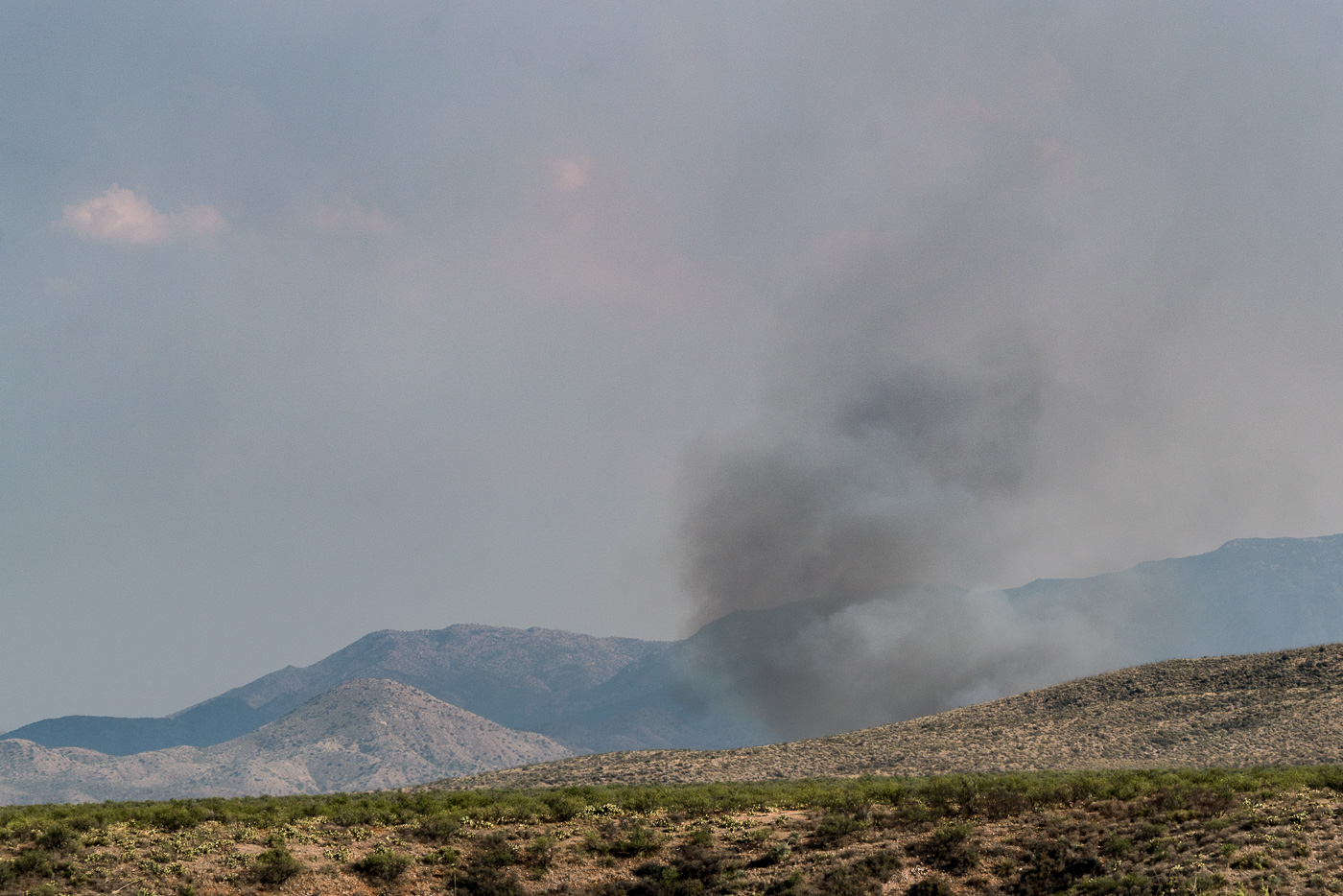
Smoke from the Burro Fire – Guthrie Mountain to the left. July 2017.Airplanes drop fire retardant on flames trying to come over a ridge – near Guthrie Mountain. July 2017.Looking down into a smoke obscured the San Pedro Valley – Edgar Canyon on the left. July 2017.Smoke and flames from the Burro Fire. July 2017.
5,000 acres (7/2/2017, 11:37:15 AM)
Redington Road closed from milepost 2 to 14 due to Burro Fire.
Burro Fire updates! Evacuations have started. They begin at mile marker 0 up to Palisades Road. North of Palisades Rd is under a pre evacuation status. We understand this decision is sudden however based on the activity of the fire this is the safest and best decision for our residents. Please follow social media and MyAlerts.pima.gov for more updates to follow. Pima County Office of Emergency Management can be found on Facebook at: https://www.facebook.com/pcoem/
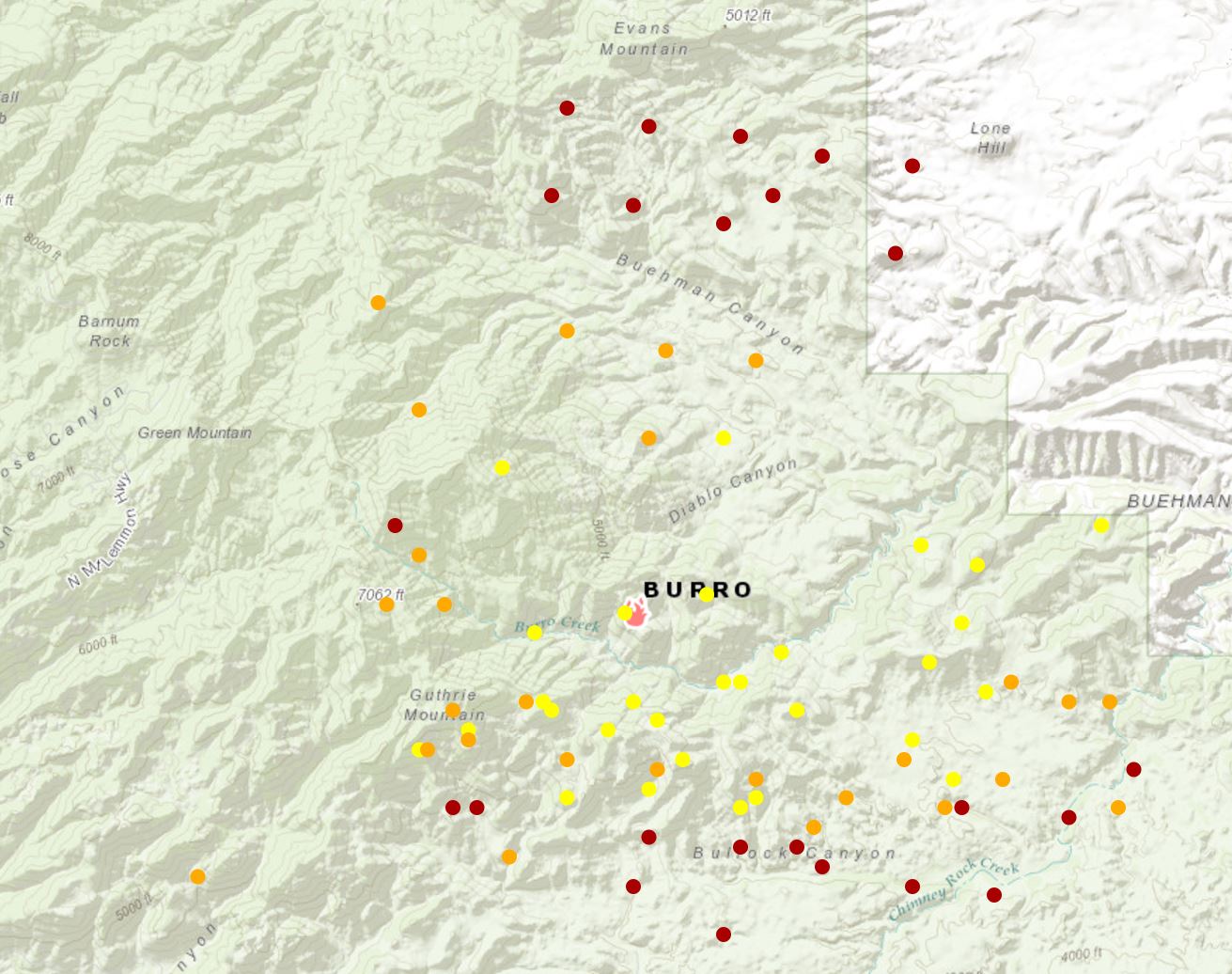
Maps suggest that the fire is currently burning between Bullock and Buehman Canyons and is still east of the Green Moutain Trail and just inside the National Forest boundary to the East.
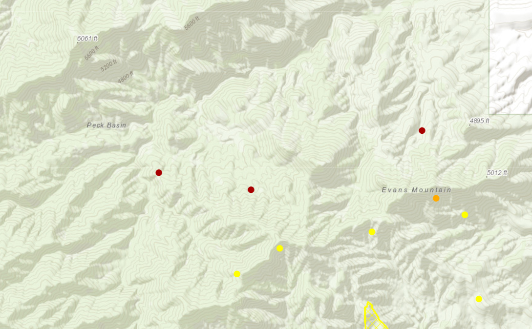
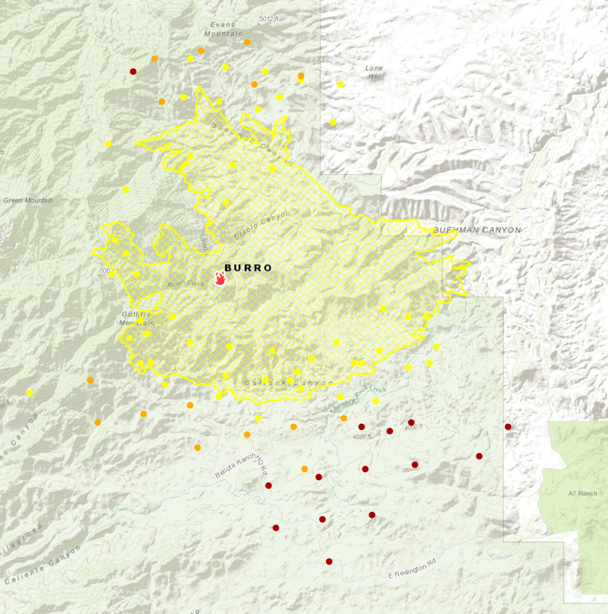
National Fire Situational Map from about 5pm on 7/2/2017 – the yellow/orange/red dots help show the Burro Fire. July 2017.
Sunset from the Pontatoc Canyon Trail. March 2017.
The Molino Fire started on April 4th in the Molino Basin area – the fire was quickly contained and limited to 50 acres. The Forest Service has suggested that the fire was caused by recreational shooting and is seeking information on a ‘person of interest’ – “a tall, white man of husky build wearing a light-colored hat, gray shirt, shorts, and tennis shoes. Witnesses saw him move toward a forest green, mid-1990s Ford Explorer parked in the area.” If you have any information please report it to the Coronado National Forest Supervisor’s Office at (520) 388-8300.
Hikers: Commercial horseback rides are damaging popular Oro Valley trail – Arizona Daily Star: Last month I mentioned a letter in the Arizona Daily Star that was critical of the condition of the Linda Vista Trails since the Tucson El Conquistador Golf & Tennis Resort began offering guided horseback rides on the trails about 6 months ago. There is now a petition that has been given to the Forest Service asking that the renewal of their permit for commercial use of the trails be denied. The Forest Service commented that “an evaluation of the condition of the trail will be completed before a decision is made on renewal of the use permit in May” and a representative from the El Conquistador said that “said the guides leading the rides “want to make sure (the trail) looks good for anybody who visits the area. From a cleanup standpoint, they do quite a lot of cleanup.”
Community members continue to push for improvements to the Sabino Canyon Tram including electric vehicles, credit card payments and an alternative to the current loud narration – an article by Tim Stellar for the Arizona Daily Star contains a number of interesting details including information from an interview with Sabino Canyon Tours owner Donn Ricketts, well worth reading – Pressure increases to get new Sabino tram operator | Latest Tim Steller columns | tucson.com – Arizona Daily Star, Letter: Sabino Canyon needs a new tram – Arizona Daily Star
Rescues/Accidents/Incidents including information from the SARCI Newsletter:
3/4/2017 Pima Canyon Trail: Exhausted hiker helped out
3/6/2017 Pima Canyon Trail: Ankle injury results in a carry out
3/10/2017 Bug Spring Trail: Head Injury
3/10/2017 Seven Falls Trail: Exhausted hiker – walked and then ridden out by horse
3/11/2017 Romero Canyon Trail: 4 hikers assisted out
3/11/2017 Aspen Trail: Lost hikers found and assisted out
3/11/2017 Sycamore Canyon: A group of 8 descending the canyon – they separated into several groups – 1 hiker was unable to follow the Sycamore Reservoir Trail and turned up Bear Canyon (found and helped) – three exhausted hikers were given water/food and gear to spend the night and then short-hauled out the next day.
3/12/2017 Seven Falls: Injury results in a short-haul out
3/13/2017 Bear Canyon: Ankle injury is assisted out on foot and horseback
3/13/2017 Pima Canyon Trail: Ill and unresponsive hiker flown out
3/14/2017 Butterfly Trail: A head injury in the Novio Spring area eventually results in a hiker being flown out
3/16/2017 Bellota Trail near La Milagrosa Canyon: Chest pains reported by a hiker via Personal Locator – hiker flown out
3/18/2017 Palisades Canyon: Rockfall injury during a canyoneering descent – two party members flown out, two assisted out on foot
3/19/2017 Willow Canyon: Hikers became lost in the Rose Canyon Lake area and are assisted out after ending up in the Seven Cataracts drainage
3/20/2017 Window Peak: Hikers become lost when they take the trail up to Window Peak rather than heading down – hoisted out the next morning
3/21/2017 Bear Canyon Trail: An exhausted hiker with medical complications and ankle injury are assisted out
3/25/2017 Seven Falls Trail: A fall on the trail results in a hiker being unresponsive for several minutes – carried and flown out
3/29/2017 Romero Pools: A fall results in a head injury – injured hiker was flown out
Sunset from the Pontatoc Canyon Trail. March 2017.
Sabino Canyon is a beautiful destination but it is often crowded on any weekend with (even vaguely) good weather. Holidays can be particularly busy – to help with the congestion from Dec. 26 to Jan. 2 there will be a shuttle from Udall Park to Sabino Canyon. The shuttle will start at Udall Park at 9:15 and run each hour – the last shuttle will leave Sabino Canyon at 4:45. The shuttle can carry 40 people and it could be a nice way to avoid a packed and frustrating experience in the Sabino Canyon Parking Lot!! I believe this is the first year this service has been offered – it might be best to keep a little flexibility in your plans just-in-case the shuttle is full or not quite on time… Free holiday shuttle could help ease Sabino Canyon’s parking hassles | Government and politics | tucson.com – Arizona Daily Star, Free Electric Shuttle To and From Sabino Canyon During Holiday Break – City of Tucson
Redington Pass Shooting Closure Extended, One Area Reopens – Coronado National Forest: The shooting closures that has been in place since 2013 has been extended and slightly modified. The area was originally closed while trash and debris related to shooting were removed and the extension is designed to help the area to recover. From the Forest Service:
According to the closure, shooting will be prohibited within 0.6 miles on either side of the road from the western boundary of the Forest to mile marker 6.3. The previous closure prohibited recreational shooting from mile marker 5 to mile marker 7.
Raven euthanized after caught in leg trap in Redington Pass – KVOA.com: A rather sad story about a Raven found in a baited leg hold trap in the Redington Pass area who was eventually euthanized – these traps are illegal on public lands as is trapping Ravens.
Authorities need help after deer poached in Catalina Mountains – Tucson News Now: “A $1,000 reward is being offered for tips leading to the arrest of the person who killed a Whitetail deer in the Santa Catalina Mountains last month. The Arizona Game and Fish Department said the animal, an untagged Whitetail buck, was found Oct. 9 off Forest Service Road 4496 in the Charoleau Gap area.”
A Career of Her Own: Edith Shreve at the Desert Laboratory – University of Arizona Campus Repository: Janice Bowers wrote about Forrest Shreve, who worked at the Desert Labratory in Tucson, in the book A Sense of Place - The Life and Work of Forrest Shreve – she also authored this article about Edith Shreve. The article is from 1986 but I had not come across it until recently – it is an interesting read and includes a picture of Edith Shreve during an expedition into the Santa Catalina Mountains in the early 1900s! The name Shreve will be familiar to dedicated Santa Catalina Mountain hikers because of Shreve Saddle on the Sycamore Reservoir Trail.
In November, after the release of 20 more Bighorn into the Santa Catalina Mountains, Arizona Game and Fish declared that the population has reached a sustainable level and that:
No more releases are planned
monthly updates about the project will no longer be released
not all of the sheep released had GPS collars attached
Mountain Lions that kill Bighorns will no longer be pursued
AZGF Research Projects are scheduled to end in June 2017
I suppose at this point it will be many years until we know if this project was truly successful…
Rescues/Accidents/Incidents including information from the SARCI Newsletter:
Wilderness of Rocks 10/1/2016: Hiker stranded by darkness is found off trail near the Wilderness of Rocks/Lemmon Rock junction
Windy Point 10/6/2016: An injury requiring a carry out of the patient
Sutherland Trail 10/8/2016: A hiker on one of the many social trail off the Sutherland Trail in the Catalina State Park area became exhausted and was carried out
Sabino Canyon 10/13/2016: Hikers requested help after hiking down canyon past the guaging station and were helped out
Aspen Trail 10/15/2016: Hikers lost the trail but were able to find the trail and reach their vehicle before help arrived
Butterfly Trail 10/17/2016: A biker on the Butterfly Trail lost the trail in the Novio Spring area and was extracted.
Snow hiding in the shadow of Mount Bigelow. December 2016.
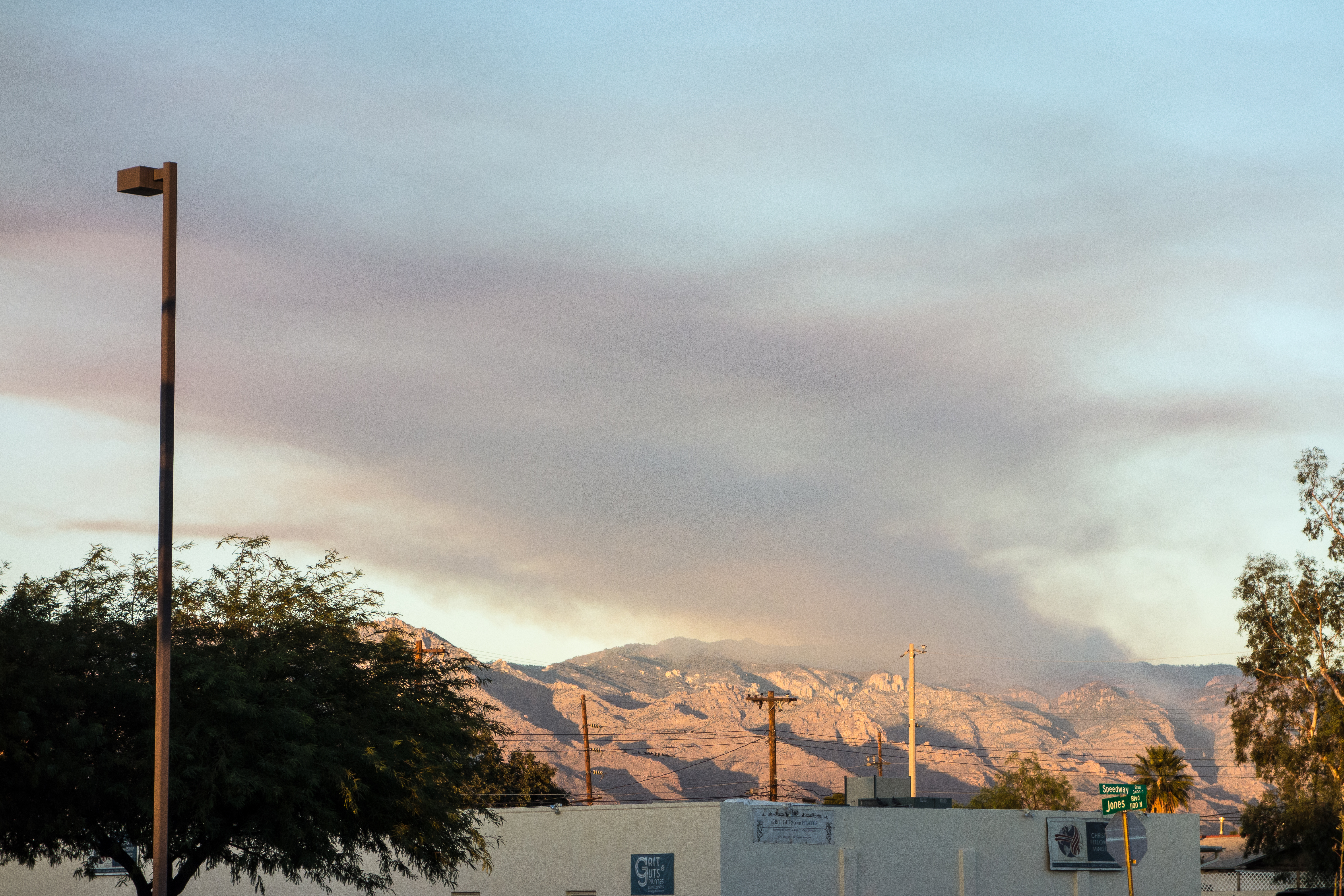
Smoke from the Bigelow Prescribed Burn – taken from Speedway Boulevard in Tucson. December 2016.
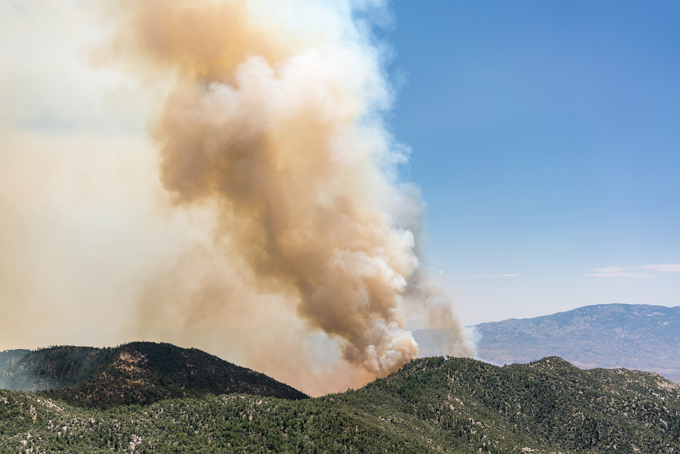
The Forest Service was careful to publish information about the Bigelow Prescribed Burn well in advance – but even so it was hard not to be alarmed by the impressive amount of smoke that the fire was producing, easily visible from Tucson it generated plenty of questions and it was hard not to wonder if the controlled burn had somehow gone awry…
A small pine along the Bigelow Trail in the Bigelow Controlled Burn area – many of even the smaller pines still had green needles and appear to have survived the fire. December 2016.
Hiking up the Bigelow Trail from the Bigelow Trailhead the impact of the fire was obvious – black ground, black tree trunks. I wasn’t until I reached the edge of the burn that I could really tell just how impressively effective the fire had been – fairly dense grass and shrubs cover the hill on one side / on the other the ground is remarkably clear.
Grass and shrub covered hillside on the left of the trail, burned – and cleared – ground on the right. December 2016.
We visited Kellogg Mountain just before the controlled burn – I wondered what impact the fire might have on the impressive thicket of New Mexico Locust growing near the top – but near Kellogg the Bigelow Trail was the edge of the fire and Kellogg Mountain was untouched.
Looking up at Kellogg Mountain from the Bigelow Trail – Kellogg was untouched by the Bigelow Controlled Burn. December 2016.