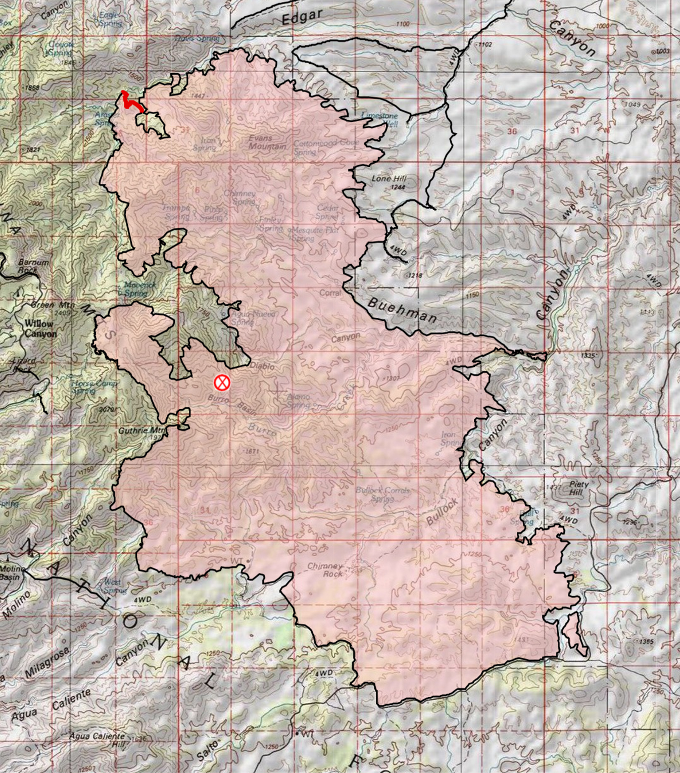
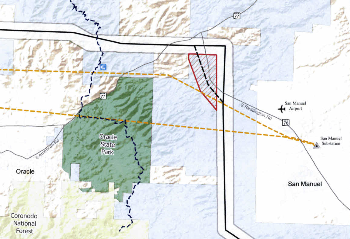
The proximity of SunZia’s route to the San Manuel Ray Blair Airport triggered an FAA review of the project resulted in several notable changes – the proposed route of the line now runs closer to Oracle State Park, lines in the area will be required to have marker balls and 21 of the towers will have lights on top. A string of glowing lights in the San Pedro River Valley would be a disappointing addition – I am unsure about the impact to the views from Oracle State Park but this is a particularly unwelcome addition considering the International Dark Sky Park designation that Oracle State Park has achieved. This change has not yet been officially approved so there is some hope that a better solution might be found. The Arizona Corporation Commission eDocket for SunZia has documents related to this proposed change including comments from the Friends of Oracle State Park and Cascabel Working Group.
SunZia – FCC Route change bringing the line closer to Oracle State Park – not indicated on this map are the locations of the 21 towers that will require lights… February 2019.
In October of 2018 the New Mexico Public Regulation Commission approved the location of Pattern Development’s Corona Wind Projects which allows construction to begin on an estimated 950 wind turbines. The projects – Duran Mesa, Cowboy Mesa, Red Cloud, Tecolote, Ancho and Viento Loco – are located in Lincoln, Torrance and Guadalupe counties in east-central NM. The project includes a 140 mile transmission line project that will connect this project with SunZia so that the generated energy can be sold to western states. Pattern Energy announced that purchase agreements have been made with Silicon Valley Clean Energy and Monterey Bay Community Power in California. A Utility Dive article indicates that Pattern Energy will be working with SunZia on the resubmittal of their application to the New Mexico Public Regulation Commission.
North – Davis Mesa Road to Peck Spring – Summer
Saguaro ribs along the SunZia route north or Davis Mesa Road. July 2018.
Wandering cross-country thru the saguaros has a rhythm, a shape – step forward step forward; — pause — look; step to the side, squeeze thru, step forward step forward… Sometimes your path doubles back on itself and starts again – sometimes it curves with the landscape – never steady, never straight, infinite variations on a theme.
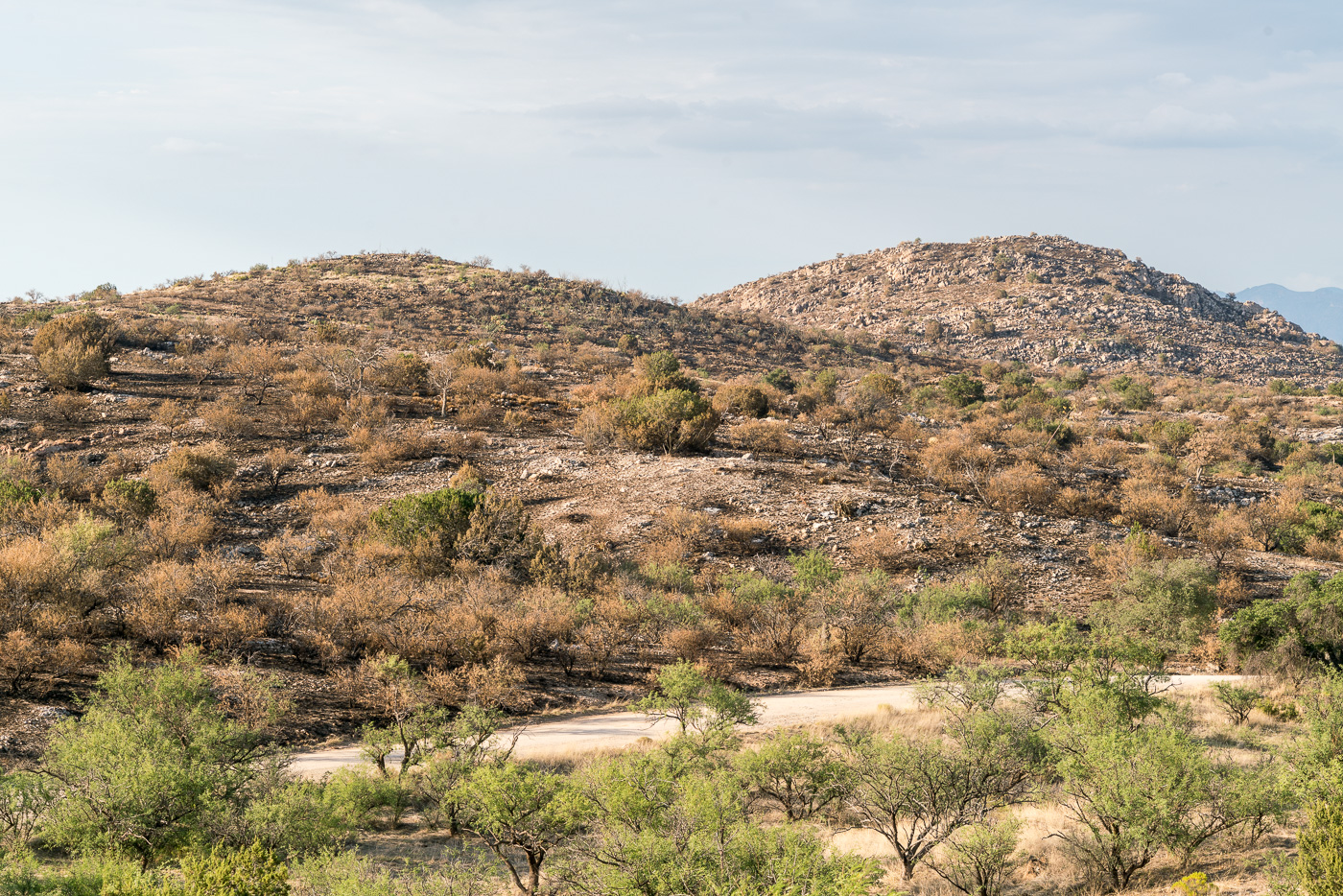
North of Edgar Canyon and the Davis Mesa road the SunZia Transmission heads north – white hills, red hills and down into flatter terrain before turning to the northwest to parallel the existing gas line. Previous section that I hiked had deep canyons – substantial vertical gains and losses – SunZia’s route is obviously a straight line on the map, but the experience of trying to follow it across broken terrain really didn’t bring to mind straight lines and clean angles. Today is different – a straight line thru this gently rolling desert is alien, infuriating – SunZia’s mechanical progression out of place and lacking grace, even the old road towards Peck Spring curves and matches landscape…
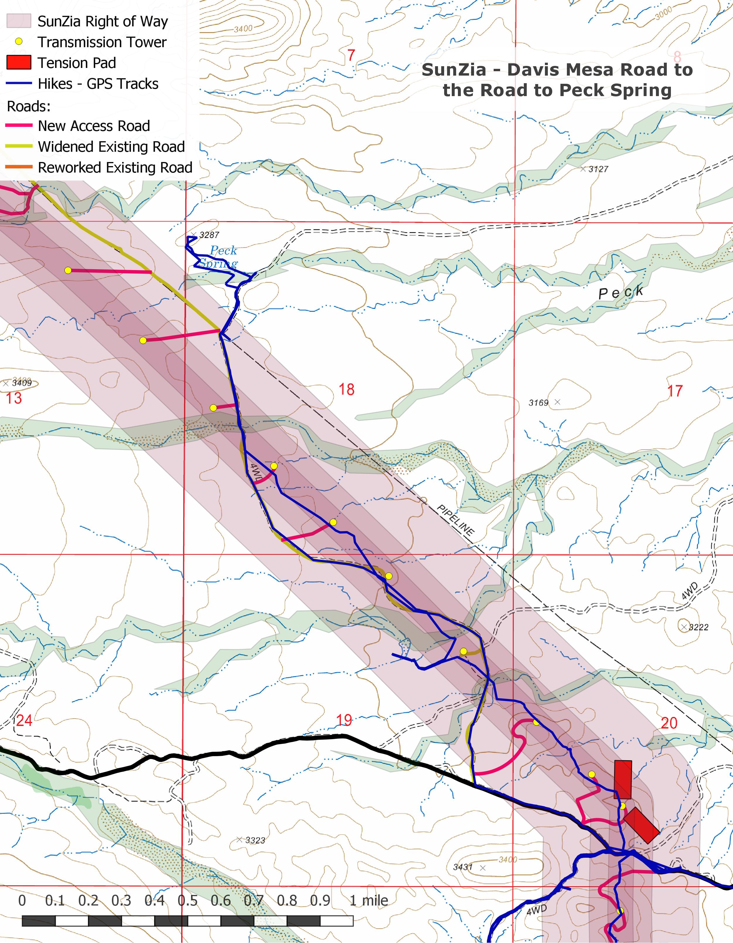
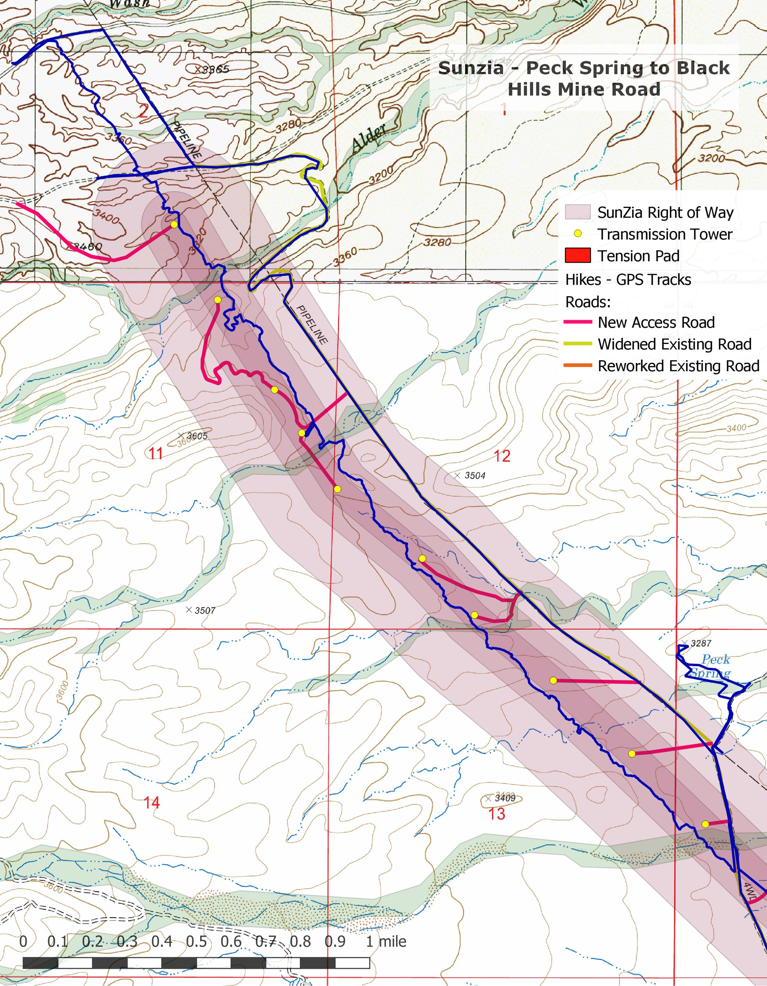
In this short section there will be 7 towers, 2 tension pads and 5 new access roads – it is nice to turn away and make the short walk to the Peck Spring area.
SunZia Route – leaving the Davis Mesa. July 2018.Fallen Saguaro fruit along the Sunzia Route. July 2018.Red rock along the SunZia route. July 2018.East side of the Santa Catalina Mountains from the SunZia Route north of Davis Mesa Road. July 2018.SunZia Route Map – Davis Mesa Road to the road to Peck Spring. July 2018.
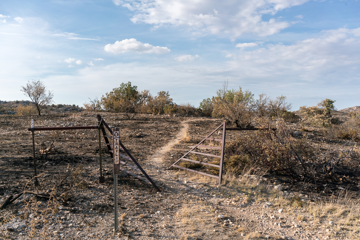
Interlude – Peck Spring
Dry tank in the Peck Spring Area. July 2018.A maze of chutes and fencing in the Peck Spring area. July 2018.Gila Monster above Peck Canyon. July 2018.Beautiful Tree shooting up from Peck Spring. July 2018.
The name ‘Peck’ predates Arizona’s statehood and surrounded by old fences and corrals I can’t help but think about the small bits of history I have learned over the past few years – from Bernard W. Muffley’s 1938 History of the Lower San Pedro Valley, pages 29-30:
In 1885 the Bayless and Berkalew Company purchased the homesteads of William and Edward Peck. Near by on a school section they founded a ranch later known as the Sacaton. From this humble beginning the company gradually increased its interests until at one time it comprised 9000 acres of patented land. Starting about the same time, Demitrus Markham built up a large ranch between Sacaton and Reddington. Later, however, this land was acquired by Bayless and Berkalew. The trade of this section of the San Pedro Valley became so important that in the summer of 1885 a road was constructed across Cabadillo Pass into the San Pedro Valley. On this same road Dr. C. H. Davis, brother of W. C. Davis of the San Pedro Valley, was ambushed and killed by the Indians early in June, 1886. Thus the fact is shown that bands of renegade Apaches were still at large.
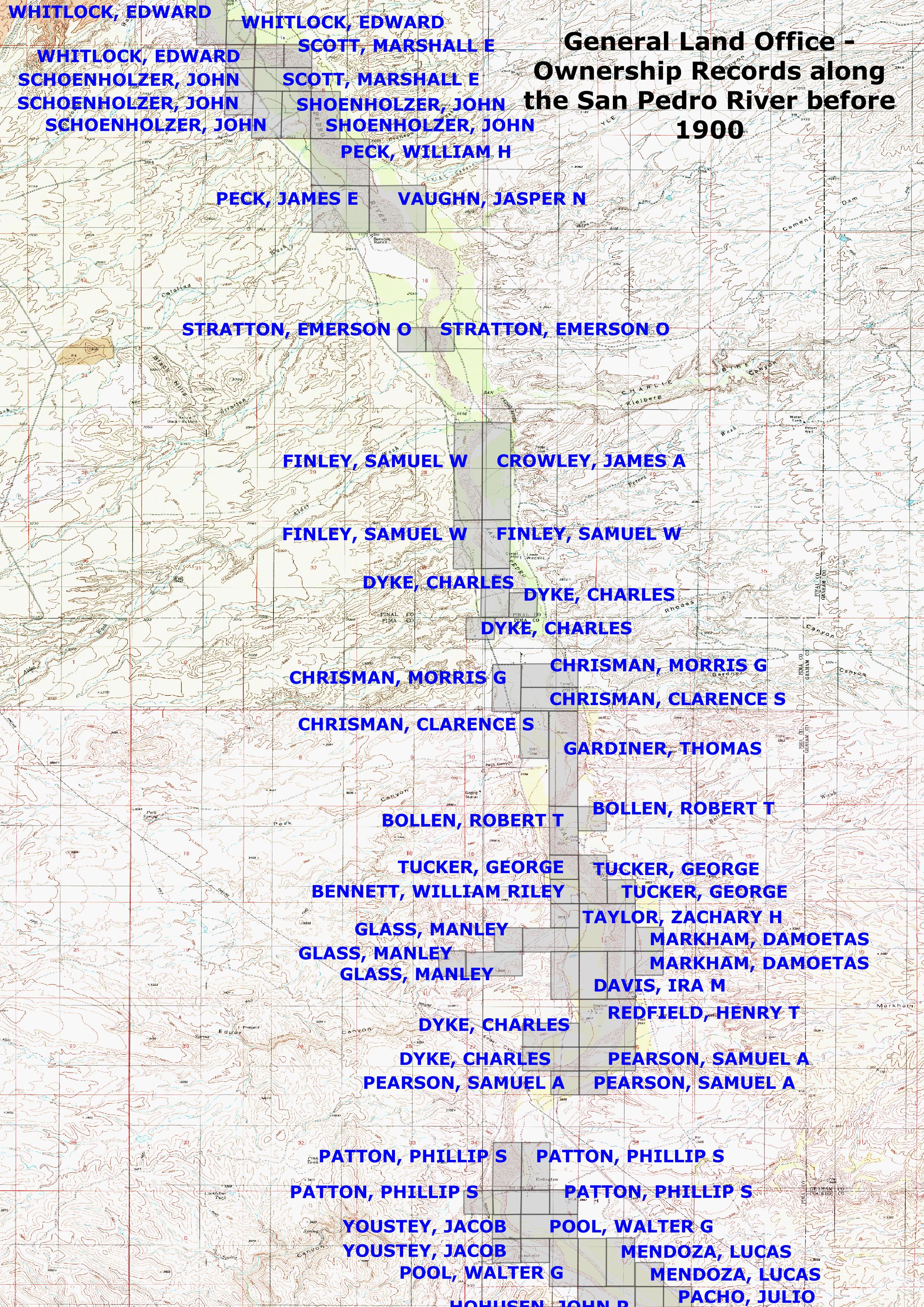
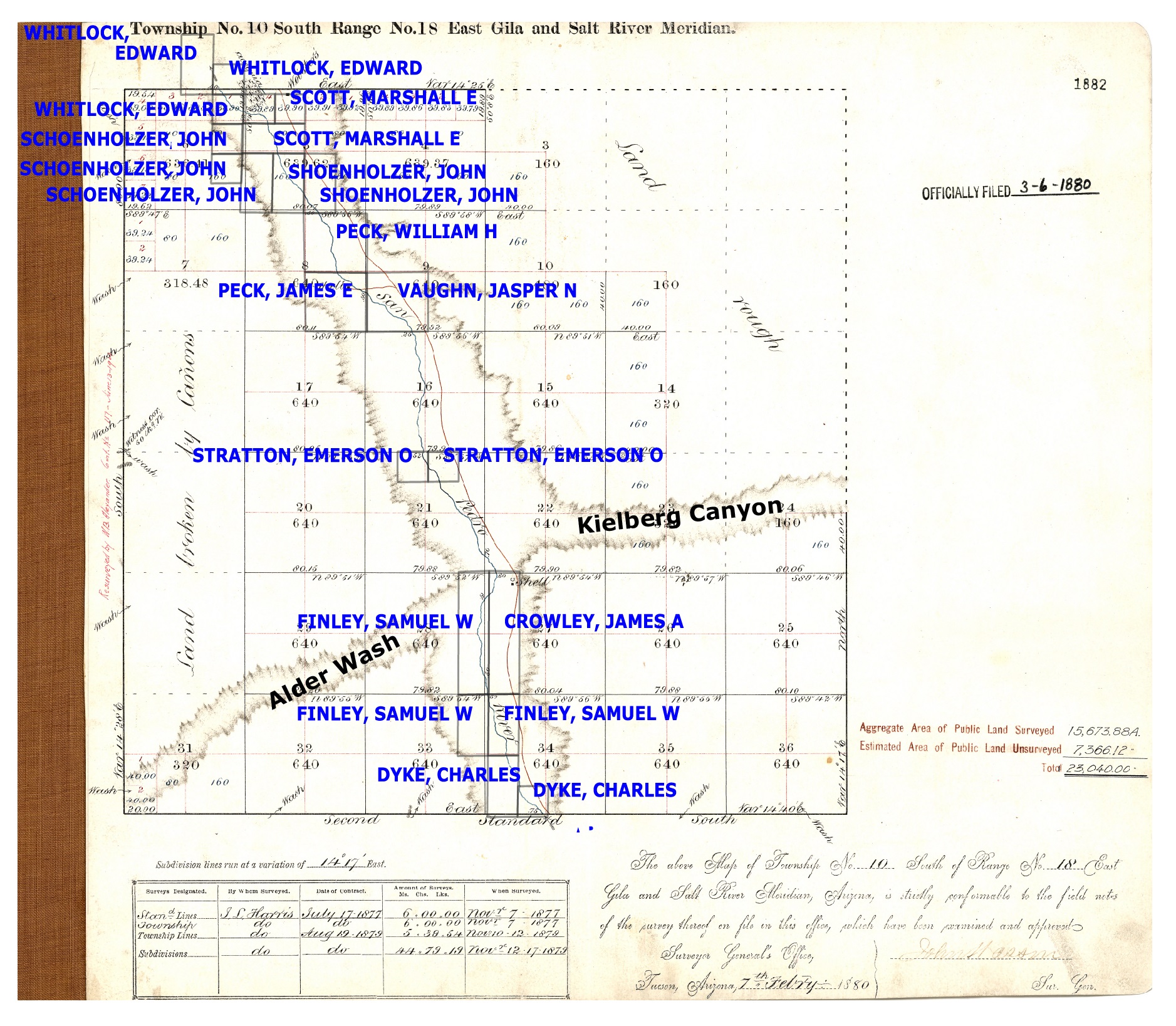
The map below is drawn from the Bureau of Land Management’s General Land Office Records and shows land ownership along the San Pedro before 1900. Of course the San Pedro River Valley has been inhabited for thousands of years, in the big picture all the names here represent newcomers – but a number of these names make their way onto present day maps and histories. Whitlock Canyon, Peck Basin, Peck Canyon, Peck Spring, Stratton Canyon (and the very interesting Pioneering in Arizona, The Reminiscences of Emerson Oliver Stratton & Edith Stratton Kitt), Davis Mesa, Redfield Canyon, Bollen Wash, Markham Canyon… Land ownership was concentrated along the river – still somewhat true today – and the original 1880 survey for 10S18E leaves much of the land farther from the river basically blank with labels indicating ‘land rough’ and ‘land broken by canyons’.
General Land Office Land Ownership along the San Pedro before 1900. February 2019.Original Survey of Township 10S Range 18E – approved in 1880 with land ownership, including the Peck’s land, overlaid and Alder Wash and Kielberg Canyon labeled. February 2019.
South – Black Hills Mine Road to Peck Canyon – Winter
Cracks and ripples in a fallen Prickly Pear. January 2019.
It’s been some time since I followed the SunZia route – a break from the heat, a break from thinking about SunZia – but it isn’t time to stop and today I head south from Black Hills Mine Road. Rippling hills, alternating white and red soils, views across the valley to the Galiuros… But dominating the day are the cracks in the landscape – steep sided dirt and rock washes, awkward and loose, dry rocks and sand at the bottom – V shaped views down into the valley and across to the Galiuros. Cool winter weather and the occasional feeling of being nowhere – a beautiful day.
Wash and Saguaros along the SunZia Transmission Line route. January 2019.Red Sand, Prickly Pear and Brittle Bush. January 2019.Panoramic view of the Galiuros across the San Pedro River, the SunZia Route will run south on the far right. January 2019.Alder Wash. January 2019.Sand and rocks in an unnamed wash. January 2019.SunZia Route Map – Peck Canyon to Black Hills Mine Road. February 2019.
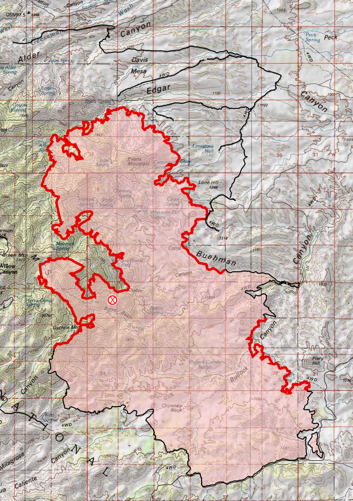
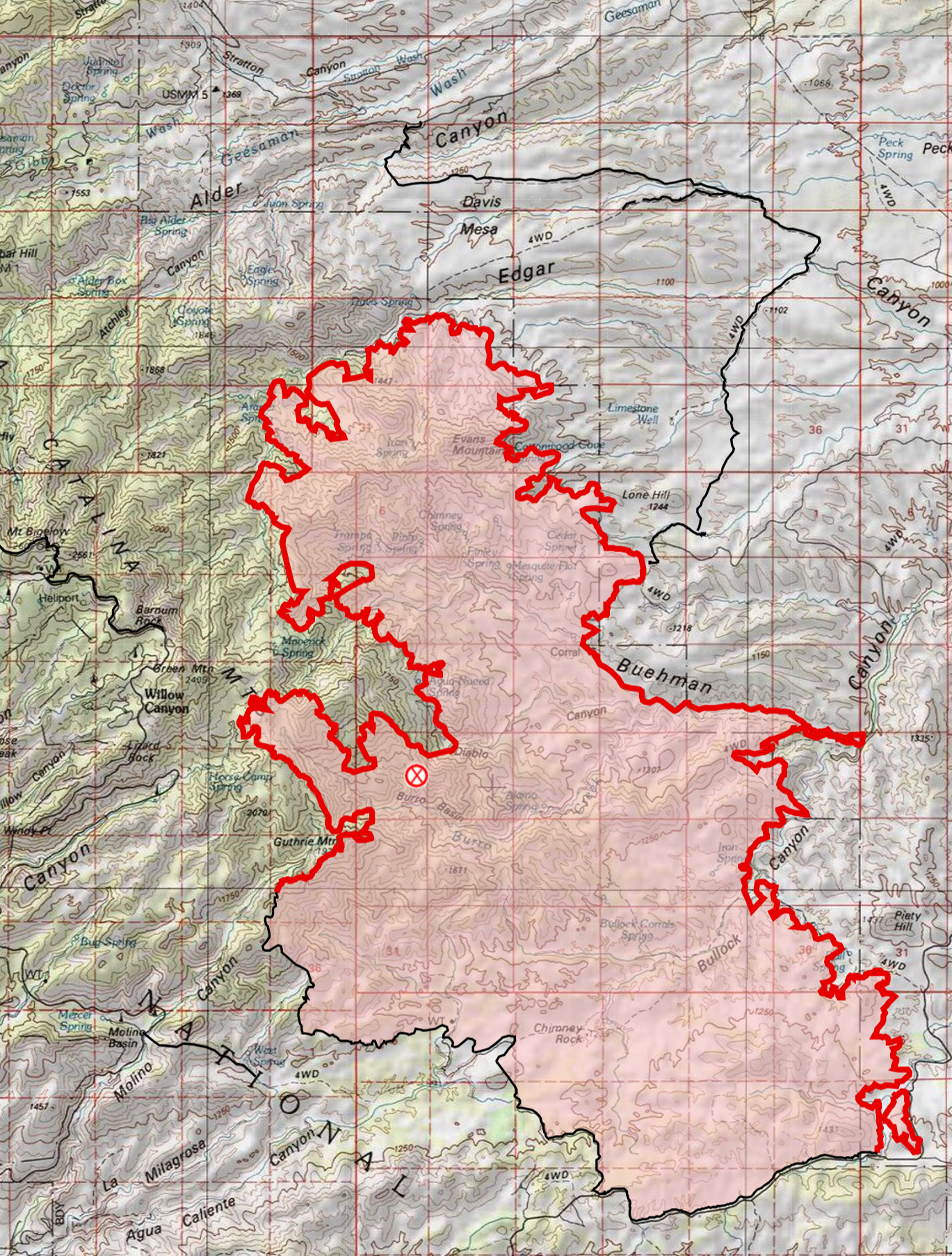
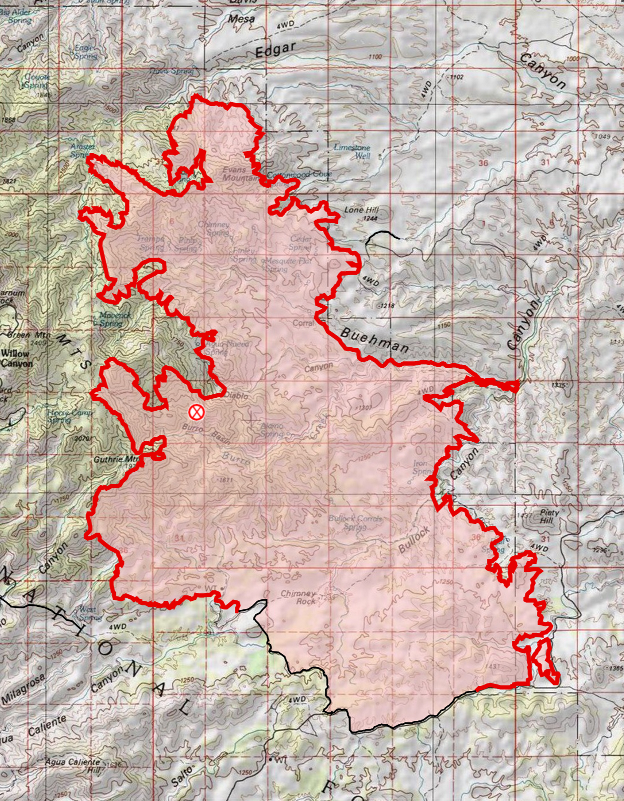
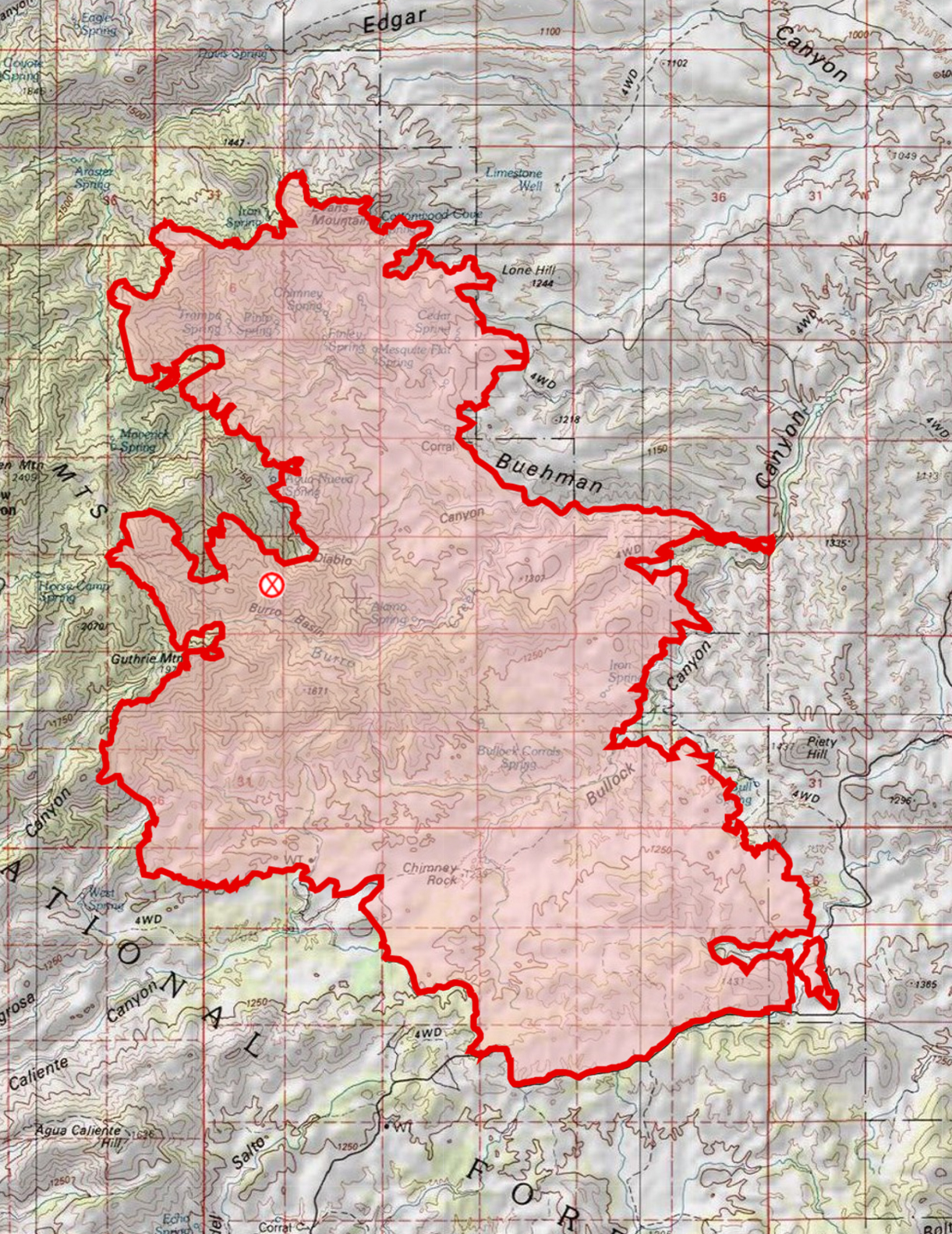
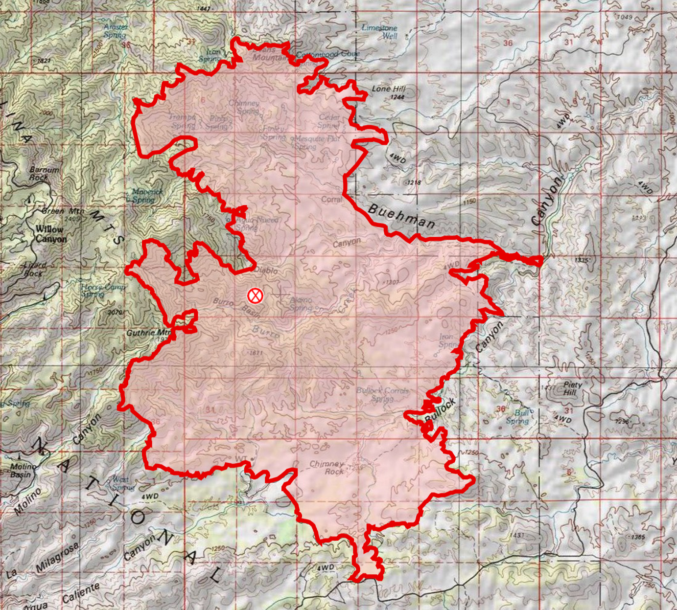
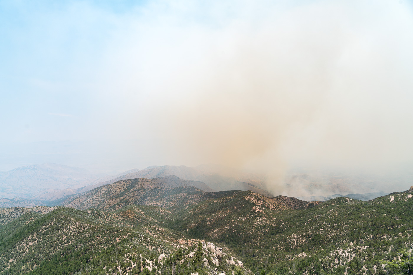
The Burro Fire started on June 30th near Burro Tank in the Redington Pass area – the fire burned 27,238 acres.
Final Update
On 7/13/2017 a final update was issued on Inciweb – the mountain will re-open on 7/14 8am and and all closures will be lifted so that all trails/trailheads on the mountain will be open!! The final size of the fire is estimated at 27,238 acres. The containment is listed at 95% (there is a small area on the NW side of the fire that on the last map still has active perimeter marked). The cause is still listed as ‘Under Investigation’.
On 7-11-2017 a revised closure order was issued ahead of the anticipated opening of the highway up the mountain to the general public on Friday. July 2017.Burro Fire – 7/12/2017 8AM – At 74% containment the only active perimeter remaining is on the NW side of the fire. July 2017.
7/11/2017
Evening: I drove Redington Road to Piety Hill to get a quick look at the impacts of the fire and fire fighting. Close to the road in the burned areas I could see the grass was gone, some or many trees were still standing and in some spots green vegetation was still visible. There were ridges in the distance that looked like they burned hotter – and near the road some of I saw was probably controlled burning by fire crews – but thankfully, at least near the road, the landscape was not a desolate moonscape!
Off Redington Road grass and underbrush were clearly burned but many trees remained. July 2017.The Burro Fire was stopped at Redington Road and in this view you can see the green vegetation south of the road and burned area north of the road. July 2017.The start of the Bellota Trail – part of the Arizona Trail – at the Italian Spring Trailhead. July 2017.
6:40 AM: Yesterday evening 65% containment was announced – and perhaps more telling about the state of the fire residents, business owners and business employees were allowed back up the mountain starting at 3pm yesterday and at this time no additional community meetings are scheduled! (The incident commander, Bea Day, did not give any estimate on when the mountain would be open to the general public.) Redington Road is now open to all traffic. The fire is listed at 27,238 acres. The current map reflects the increased containment with more of perimeter marked as contained on every side of the fire! Rain again last night should help dampen the fire and increase containment (Green Mountain, Dan Saddle and Redington gauges all show rain in the last day on the Pima County ALERT map).
Burro Fire -7/11/2017 6:39AM – the map reflects the 65% containment announced yesterday!. July 2017.
7:38 AM: 27,266 Acres, 51% Contained. Fire crews finished prepping the Control Road yesterday and added more dirt road/dozer lines to the map – the extensive circle of preparations can be seen on the map! Fire growth in Edgar Canyon was minimal even though hot/rugged conditions meant that there were not crews in the Peck Basin area yesterday – the fire continues a slow spread to the east, with hot conditions limiting crews on the ground and established lines to the east the fire is being allowed to grow in that direction for now. Progress was made containing the fire in the Piety Hill, Buehman Canyon and Guthrie Mountain areas.
7/9/2017 7AM – Burro Fire – minimal fire growth and additional containment!. July 2017.
7:40 AM: Inciweb was updated this AM to report 26,731 acres burned and 36% containment. Fire growth shown on the map this AM is modest. Fire crews with air support have been able to stop the fire at Edgar Canyon and prevent the fire from moving west into the Peck Basin area – east of this area the map now shows a much more extensive set of fire lines surrounding the fire. The southeast portion of the fire has quite a bit less active fire perimeter with area near Buehman Canyon and Piety Hill now shown in black.
Burro Fire – 7/8 AM Map – compared to the 7/7 AM map there are additional fire lines on the north and east side of the fire with only modest additional areas burning on the north and west sides. July 2017.
5:30 PM: At the community meeting they just announced 36% containment. There is a news article below about two injured firefighters – at the meeting there was a question about the injuries and it was mentioned that they were minor and the firefighters were back at work.
7:20 AM: Inciweb lists the Burro Fire at 25,355 acres and 19% contained. Compared to yesterday note the growth in the Edgar Canyon/Peck Basin area – this area was mentioned multiple times in the Community Meeting last night in part because of the concern that the fire could burn up from this area towards the highway. The map this AM also adds a substantial number of firelines compared to yesterday AM. The southwest side of the fire is now contained. On the west side preparations to hold the fire at the highway have been made including plans for burnouts if needed. On the east side a line has been established from Black Hills Mine Road, across Alder Canyon at Ventana Windmill, out Davis Mesa, across Edgar Canyon down to Lone Hill and then towards the Brush Corral Area (Black Hills Mine Road connects to the Control Road which has been mentioned as a feature that could be used to control the fire – if this line + the Control Road + the highway was held it would encircle a large section of the fire).
7/7/2017 6:50 AM – Burro Fire Map – compared to Thursday AM there has been growth in the Edgar Canyon/Peck Basin area and a substantial number of fire lines added. July 2017.
7:30 AM: The Burro Fire is currently listed as 24,547 acres with 11% containment. The map as of this AM shows the south side of the fire – along Redington Road – as contained. Since yesterday AM the northern section of the fire has grown and is burning down towards Edgar Canyon.
AM Map from July 5th – on the NE side the fire has burned down towards Edgar Canyon, on the south side there is now a significant stretch of fire line that is no longer marked as active. July 2017.
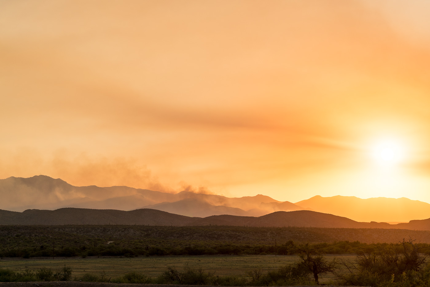
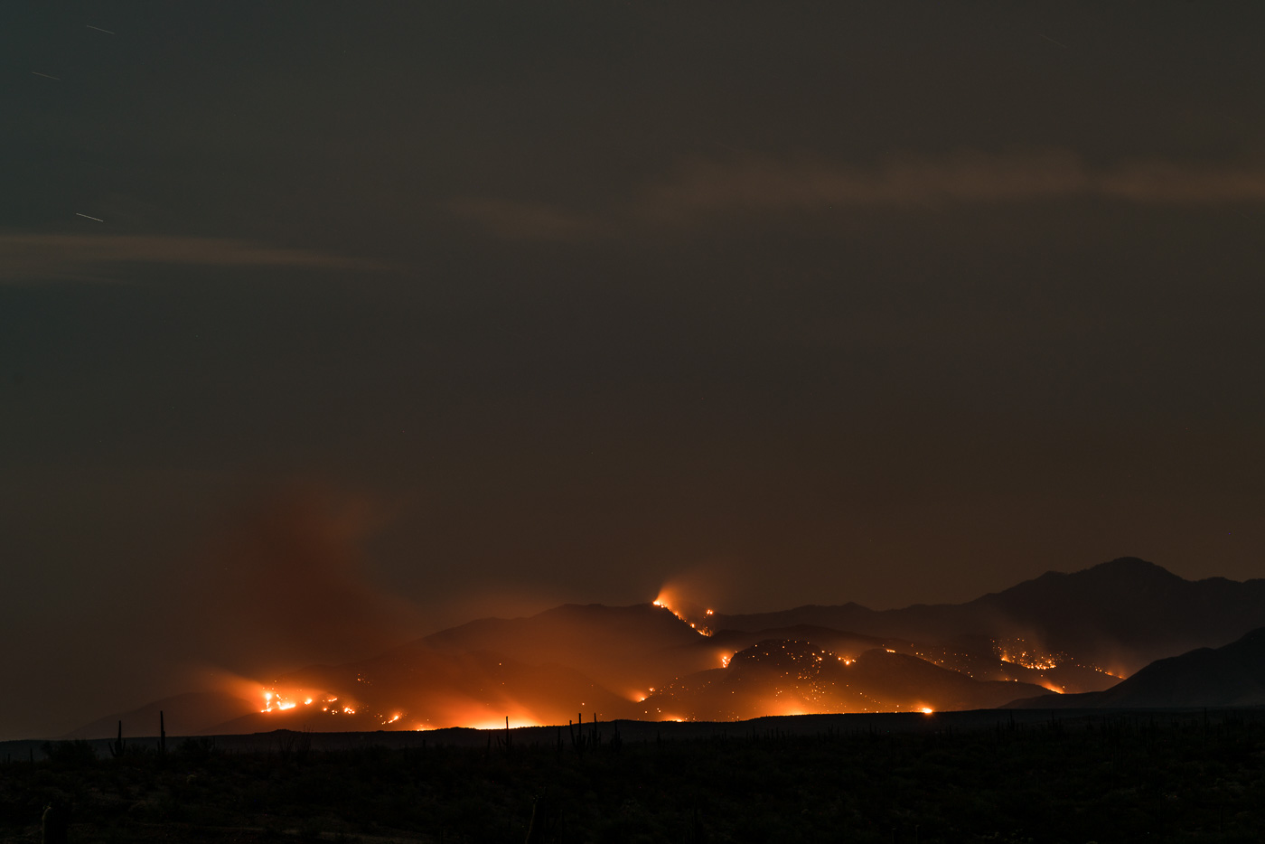
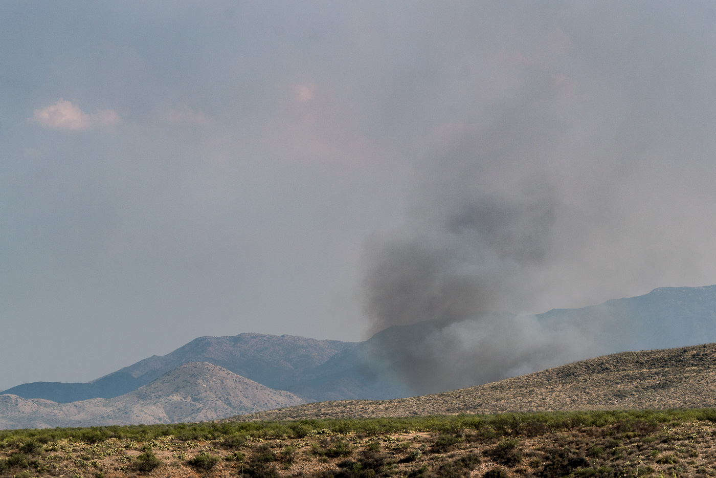
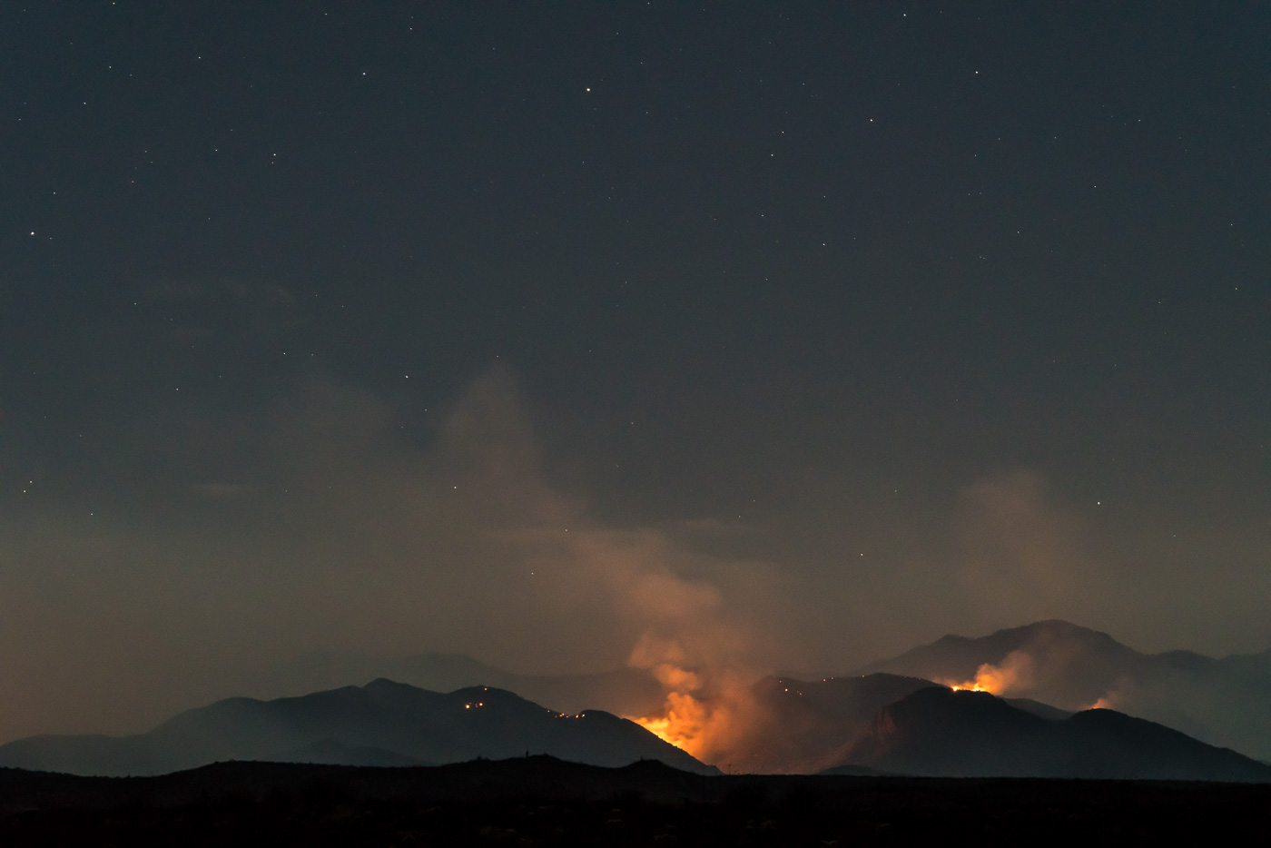
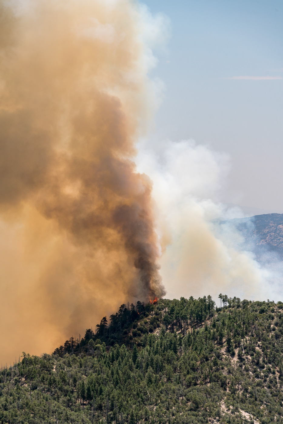
Evening/Night: Driving north from Benson the fire came into view well before the junction with Redington Road – sun, smoke and fire created several amazing views from the road. Black Hills Mine road is now closed – but with Evans mountain and the slopes down into Edgar Canyon burning the fire was easy to see from Redington Road after it climbs away from the San Pedro. The evening update puts the fire at 24,547 acres 11% contained.
Sun and Smoke from Cascabel Road. July 2017.The Burro Fire from Cascabel Road. July 2017.Evans Mountain and the slopes below burning in the Burro Fire on the night of the 5th. July 2017.
Today, firefighters strengthened control lines along the Redington Pass Road and after cold trailing and mop up of the line, declared that this section of fire perimeter is now contained. Tonight, engines will patrol the area and extinguish hot spots as needed. No additional fire growth is expected in this area.
Prep work along the Catalina Highway is nearing completion. Fire crews have reinforced Firewise mitigations put in place by residents and have set up contingency fire lines as a defensive measure. Crews are prepared to initiate burning operations in front of the fire, should it move westward, threatening structures and other values at risk.
Tonight crews will be patrolling the south eastern perimeter of the fire. Winds are predominately coming from the southeast, pushing the fire back onto itself.
The northeastern side of the fire will be monitored through the night. Incident Fire Behavior Analysts do not anticipate any substantial fire spread in this area over night.
The most active fire behavior on the Burro Fire was observed on the northwestern perimeter. In this section the fire has dropped into canyons where the vegetation is predominantly grass and scrub. Helicopters and fixed wing aircraft were used to impede the fires progress. Under current weather conditions, these canyons are in alignment with the wind, so that fire has the ability to move quickly through the light flashy fuels.
7:10 AM: Inciweb was updated this AM to list the fire at 21k acres – several notes from the update:
There will be a Community Meeting 5:30 p.m., Wednesday July 5, 2017, at the Sahuaro High School, 545 N. Camino Seco, Tucson, AZ 85710. American Sign Language (ASL) and Communication Access Real-Time Translation (CART) captioning will be provided. The meeting will be live streamed on Facebook https://www.facebook.com/BurroFireInfo/
Fire crews continued patrolling and preparing homes and other structures along the Catalina Highway. They also surveyed the terrain between the fire’s western edge and the highway to determine locations where defensive measures might be taken should the fire encroach upon the roadway.
With the support of heavy helicopters and fixed wing aircraft, fire crews built fire line along the southern and eastern flanks of the fire to protect infrastructure as well as cultural and recreational values, and were able to hold the fire north of Redington Pass Road. Despite dry conditions, high heat and outflow winds, firefighters were able to successfully protect ranch buildings in those areas. To date, the suppression efforts have ensured that no structures have been burned.
The terrain on the north eastern side of the fire is rugged and mountainous. No roads exist that would provide access for fire apparatus. Given the topography and lack of access, the decision has been made to rely mainly on air resources to slow the fire’s progress in this area. Contingency plans are in place, should fire activity become a threat to infrastructure as well as cultural and recreational values.
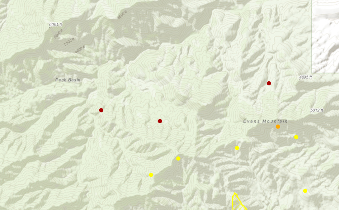
In the maps this AM I noticed two interesting details:
The satellite information on the fire suggests that the fire has made notable progress over the Evans Mountain area and is much closer to Edgar Canyon and Peck Basin.
The maps reflect the note above about holding the fire north of Redington Road – the fire perimeter on the south-east now runs along Redington Road.
Satellite information suggests that the fire has made significant progress over Evans Mountain and towards Edgar Canyon and Peck Basin. July 2017.Burro Fire Map 7/5/2016. July 2017.
Inciweb currently lists the fire at 14,112 acres although more notably the maps from the AM show quite a bit of movement to the south. From Inciweb:
Beginning July 4, Burro Fire Public Information Officers will provide media briefings at 7am and 7pm daily at the Incident Command Post at Sabino High School, 5000 Bowes Road, Tucson Arizona.
The Coronado National Forest has now implemented forest closures from Redington Pass Road and the National Scenic Trail north including Catalina Highway and the Control Rd. to the Pima/Pinal County line. These closures can be found athttps://www.fs.usda.gov/coronado/
Burro Fire Map 7/4 7:25 AM – since yesterday there has been considerable growth to the south. July 2017.Burro Fire Topo Map from 7/4 7:25 AM. July 2017.
7/3/2017
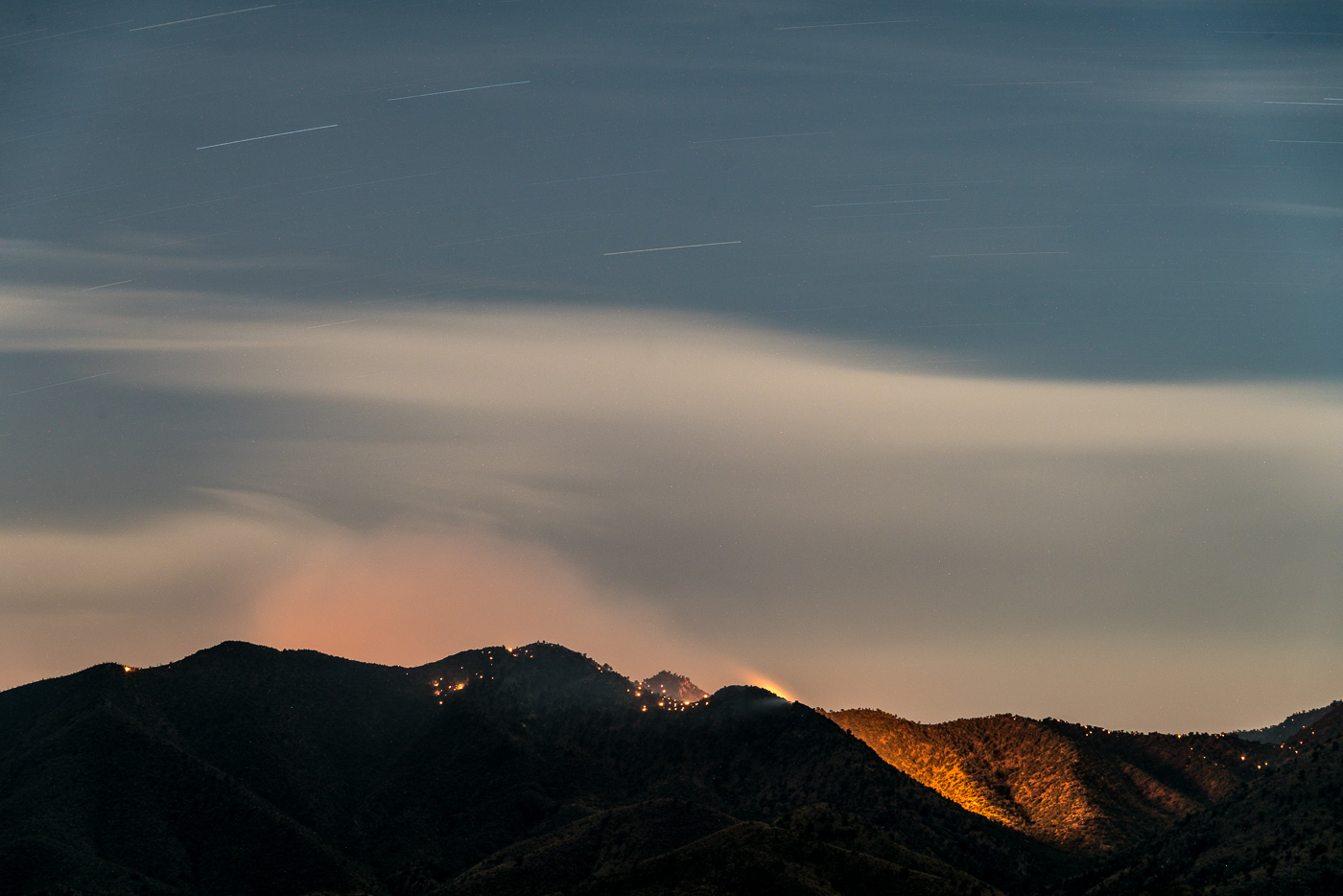
Evening/Night: With the Control Road and Highway up the mountain both closed I drove around the north end of the mountain and took Black Hills Mine Road out to the edge of Alder Canyon – this didn’t give me a view of the more active south side of the fire, but it did let me watch as flames and smoke rose from the Evans Mountain area. For the most part the fire stayed behind the ridge – but as night fell all of the small hot spots, hidden in the days, became visible… From Inciweb:
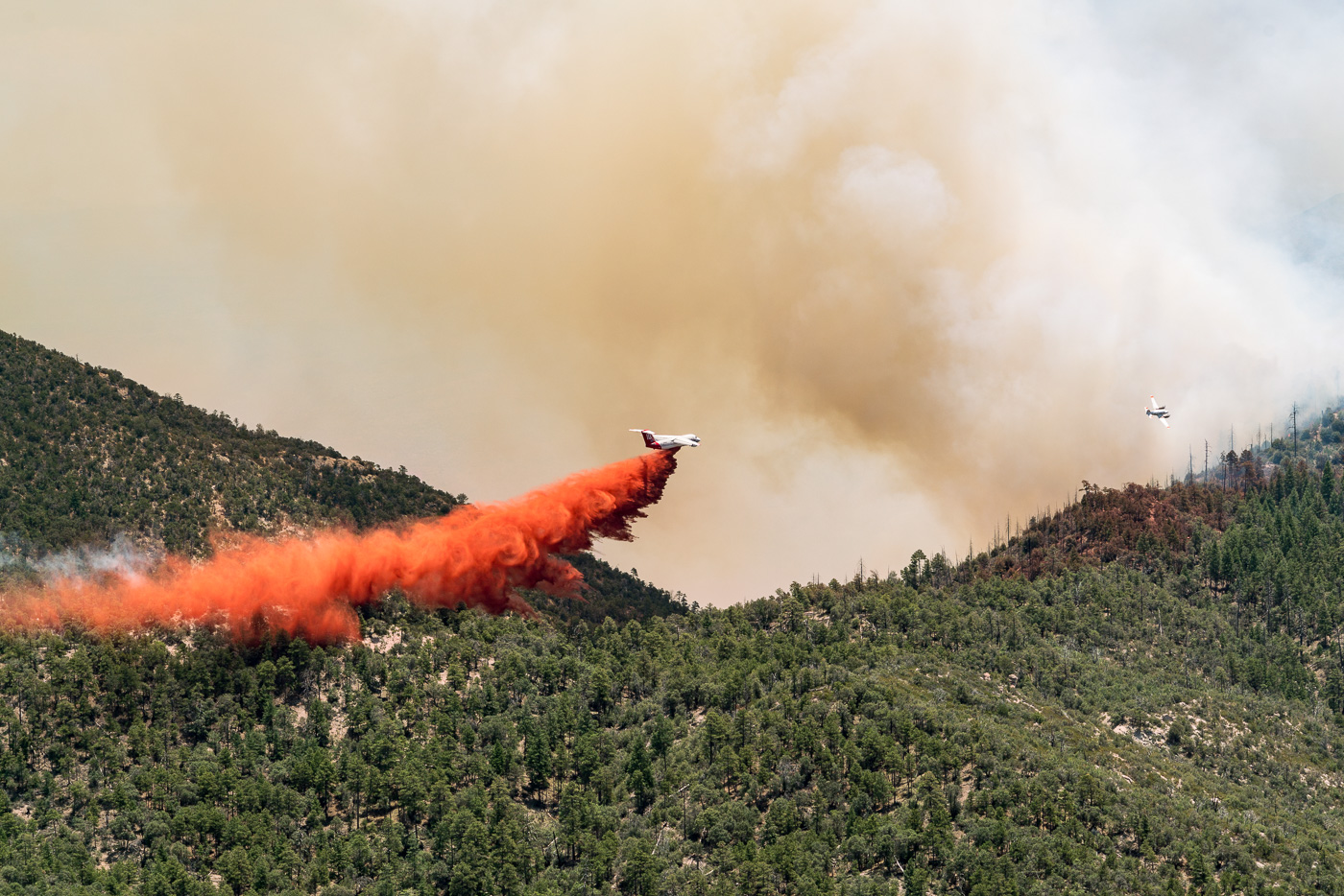
Firefighters made good progress on the Burro Fire. Indirect line construction and structural protection continued to be the focus along the Catalina (Mt. Lemmon) Highway. On the south side of the fire, firefighters continued preparation along the Redington Pass Road. Natural barriers are also being used to aid in suppression efforts. Airtankers and helicopters were used to help delay the fire’s spread where they could be used safely and effectively. With extreme temperatures, we expect to continue to have periods in the afternoons when it’s too hot to fly.
Today’s fire spread was primarily in the southern area of the fire. Firefighters provided structural protection at the Bellota Ranch.
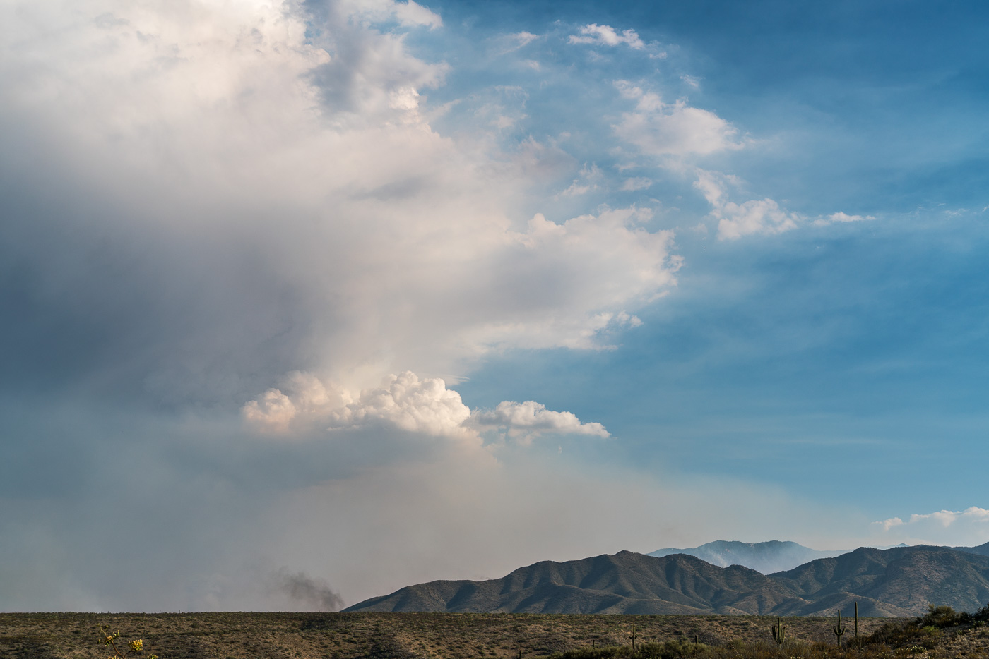
Smoke and clouds over the Evans Mountain Area. July 2017.A plume of smoke east of the Evans Mountain area with Piety Hill on the left. July 2017.Burro Fire – Evans Mountain. July 2017.Burro Fire in the Evans Mountain Area with Green Mountain in the background – from Black Hills Mine Road. July 2017.
There will be a Burro Fire Community meeting tonight, July 3, 5:30 p.m. at the Sahuaro High School (545 North Camino Seco, Tucson AZ). Please park in the main parking lot the meeting will be in the auditorium. The meeting will be live streamed on Facebook https://www.facebook.com/BurroFireInfo/. You must have an account to view the stream live. Following the meeting the recording will be posted, this will not require an account to view.
Firefighters are actively working to fully suppress the Burro Fire. Due the steep, rugged, inaccessible terrain and fire activity, firefighters are currently using indirect tactics. On the west side of the road, firefighters are planning and implementing structure protection along Catalina Highway. On the south side of the fire, firefighters are scouting and planning for preparation on holding the Redington Road. Airtankers and helicopters are being used to help delay the fire’s spread where they can be used safely and effectively. With extreme temperatures, we expect to continue to have periods in the afternoons when it’s too hot to fly.
There are currently 185 personnel working on the fire. Current resources include three hand crews, 14 engines, one water tender, and three helicopters.
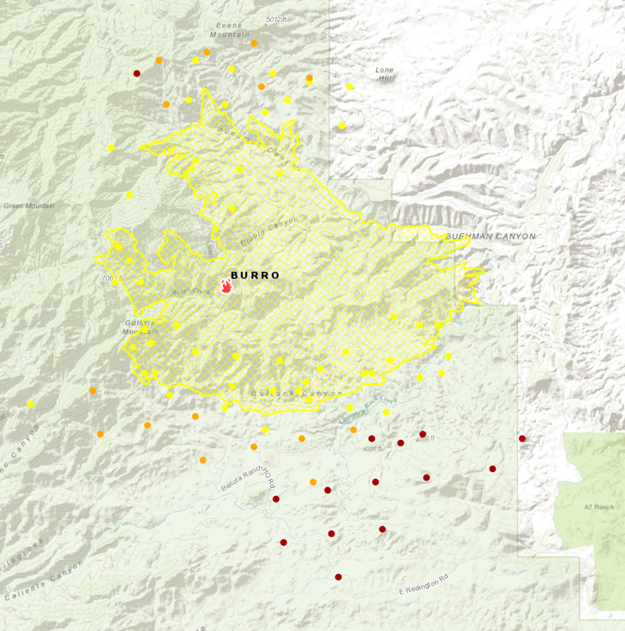
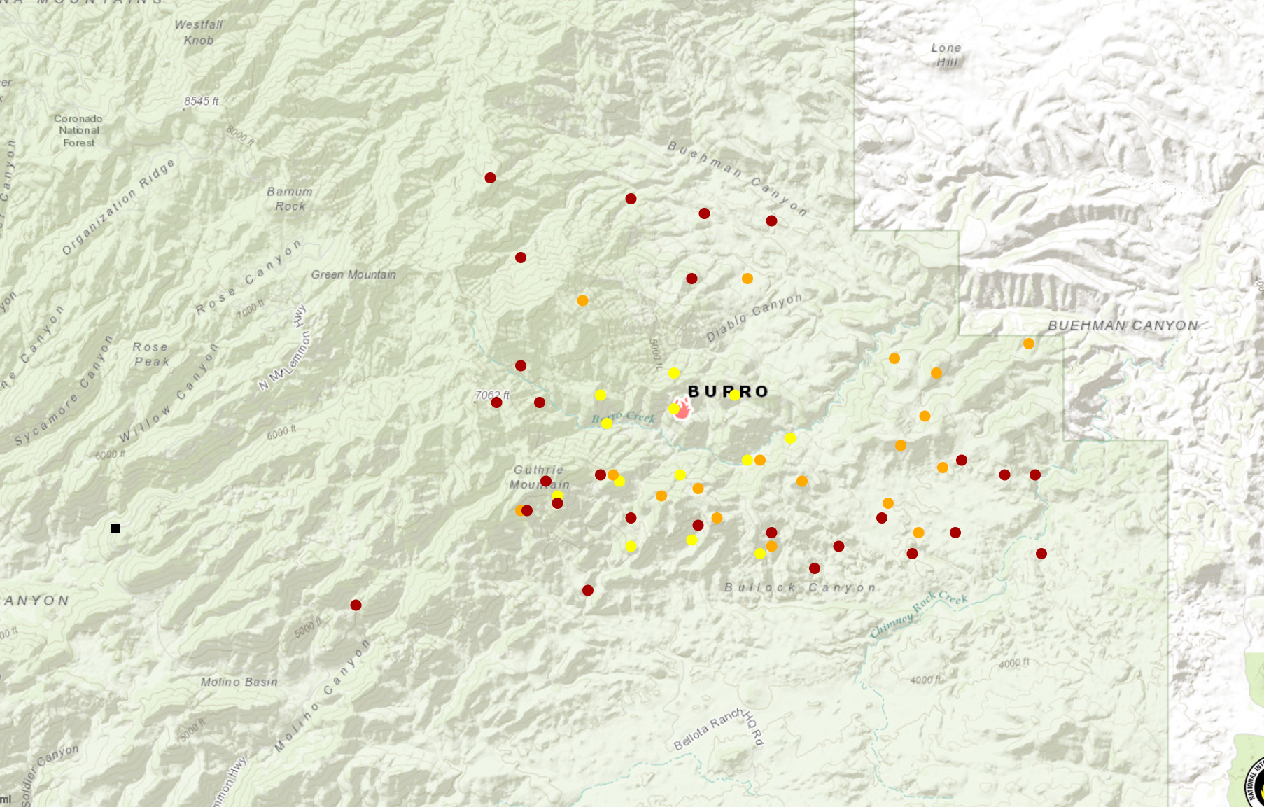
6:30 AM: Evacuations have been extended – evacuations in Summerhaven were scheduled to start at 6am this morning. Inciweb now lists the fire at 14,000 acres – up from 5,000 listed yesterday. In the map below from the The National Wildfire Coordinating Group (NWCG) it appears that the movement on the north side of the fire has been considerable – the fire has burned across Buehman Canyon and certainly looks like it will burn thru the Evans Mountain area. From Inciweb planned actions: “Assess options for indirect line construction and containment using natural barriers. Assess needs for point protection at threatened infrastructure/communities.”
National Wildfire Coordinating Group (NWCG) Map – 7/3/2017 6:17am. July 2017.
7/2/2017
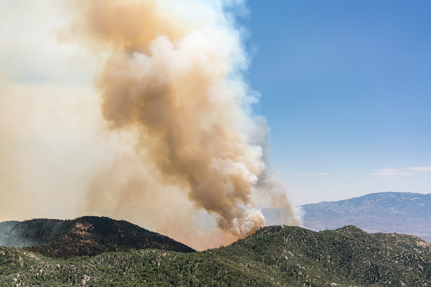
In the AM driving up the mountain the usual traffic was out on the road, you could barely smell the smoke and lower down on the mountain you had to look in the right direction to even know there was a fire. Higher on the mountain the smoke became more and more obvious… I hiked out to several points below Green Mountain to watch the fire – the smoke was impressive, scary, and larger than I expected. I watched cautiously for an hour or so as flames came up onto a ridge near Guthrie Mountain and aircraft dropped fire retardant to try to keep it in the canyon… Driving down the mountain I noticed fire personnel coming down and at the base Police had started to turn away anyone who was not a resident.
Smoke from the Burro Fire – Guthrie Mountain to the left. July 2017.Airplanes drop fire retardant on flames trying to come over a ridge – near Guthrie Mountain. July 2017.Looking down into a smoke obscured the San Pedro Valley – Edgar Canyon on the left. July 2017.Smoke and flames from the Burro Fire. July 2017.
5,000 acres (7/2/2017, 11:37:15 AM)
Redington Road closed from milepost 2 to 14 due to Burro Fire.
Burro Fire updates! Evacuations have started. They begin at mile marker 0 up to Palisades Road. North of Palisades Rd is under a pre evacuation status. We understand this decision is sudden however based on the activity of the fire this is the safest and best decision for our residents. Please follow social media and MyAlerts.pima.gov for more updates to follow. Pima County Office of Emergency Management can be found on Facebook at: https://www.facebook.com/pcoem/
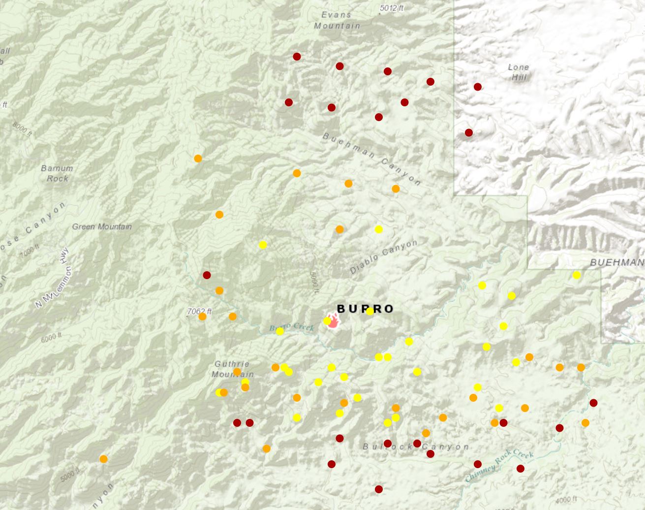
Maps suggest that the fire is currently burning between Bullock and Buehman Canyons and is still east of the Green Moutain Trail and just inside the National Forest boundary to the East.
National Fire Situational Map from about 5pm on 7/2/2017 – the yellow/orange/red dots help show the Burro Fire. July 2017.
Looking back at the Point 3224 in the Black Hills from an old road to the east. January 2017.
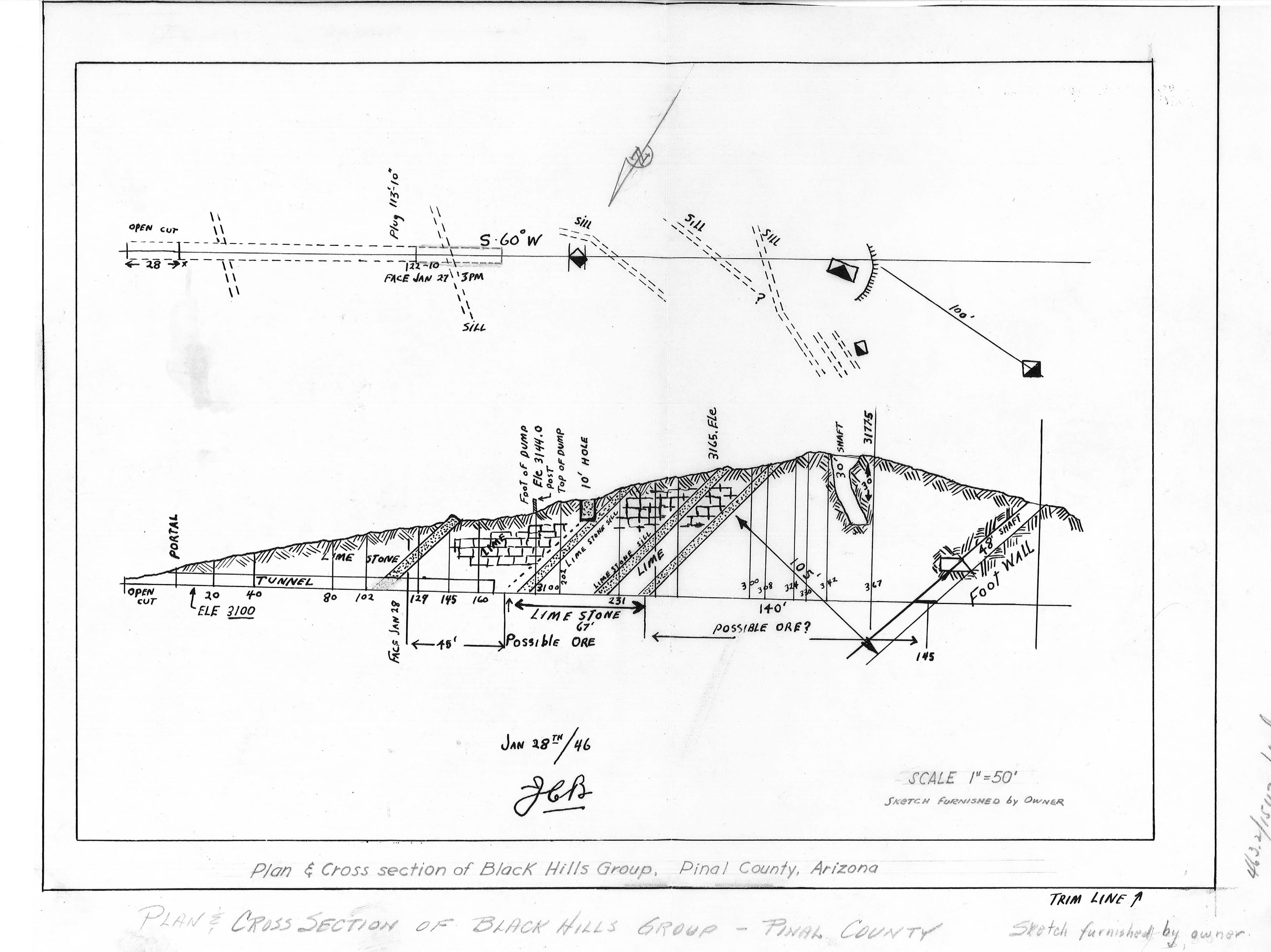
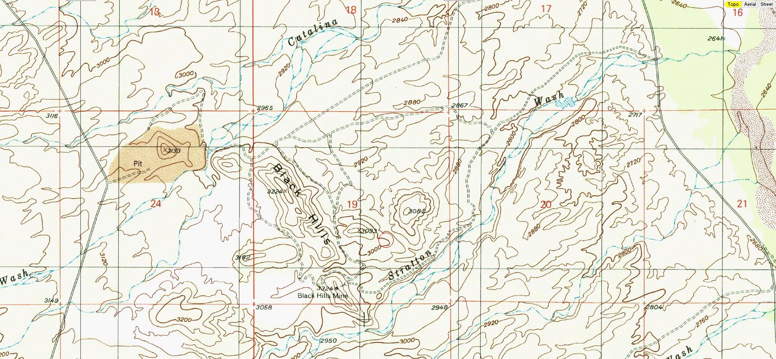
East of Black Hills Mine Road, west of the San Pedro River, north of Stratton Wash and south of Catalina Wash the Black Hills rise out of the desert on Arizona State Trust Land. A packet of information online via the Arizona Geological Survey details the mining history back into the 1940s.
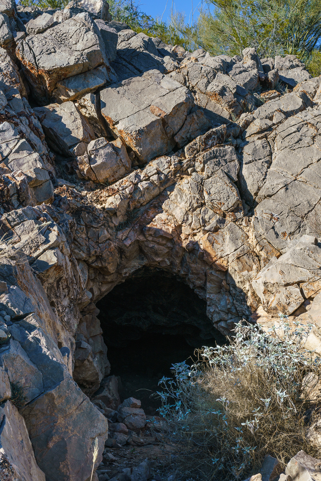
An entrance in the Black Hills. January 2017.
1947 – “Mr. Reuss and his partner acquired the Black Hills property several years ago. They built a road to it, constructed a camp, and equipped it with a small compressor and accessory tools. The partners then spent nearly two years developing the area. The chief work is a crosscut tunnel about 200 feet in length. Development abandoned when the partners ran out of funds to carry on.”
Plan and Cross Section of the Black Hills Group from a packet of information about the mine from the Arizona Department of Mines and Mineral Resources Mining Collection. January 2017.
1955 – “Proposed Plans Operators wish to sell the limestone or lime to the San Manuel Copper Corp. by selling the limestone as mined, or by installing a lime kiln to treat the limestone.”
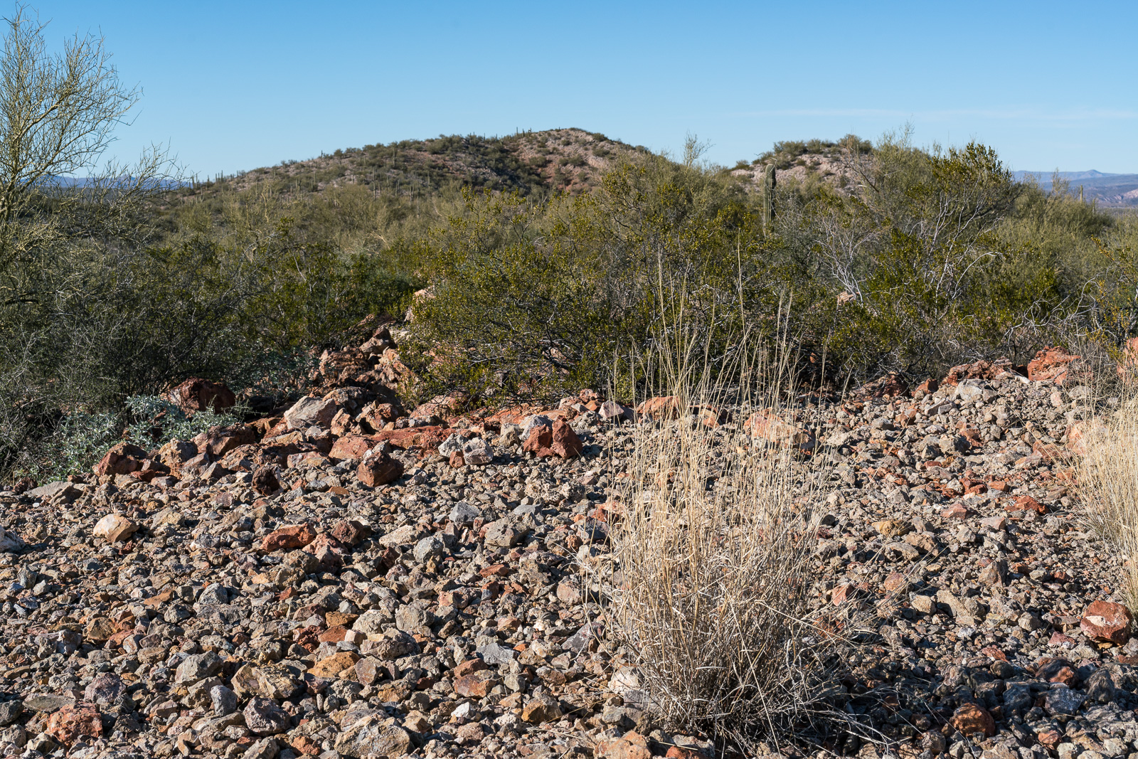
Perhaps fill over the 30′ shaft in the Black Hills Mine Group? January 2017.
1983 – “The Magma Copper Co. owns the original Black Hills Mine, Pinal County and its associated patented claims covering most of the west half of Section 19, T10S RI8E. The company also owns all of the adjacent Section 24, T10S RI7E; in the NE 1/4 of this section lies the current Black Hills limestone quarry where, according to company officials, enough limestone has been mined and stockpiled to last some 10 years.”
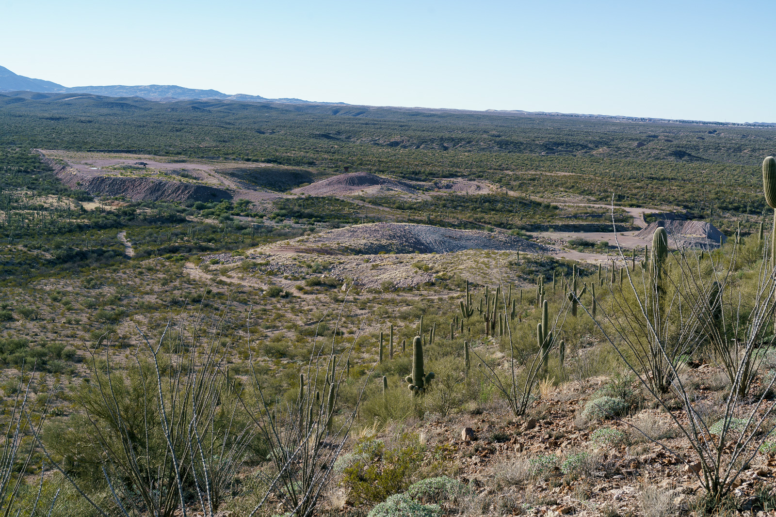
Looking down on the Limestone Quarry between the old Black Hills Mine and Black Hills Mine Road. January 2017.
For this hike I parked in a pull out on the west side of Redington Road just south of Stratton Wash and walked up the wash to the Black Hills. Stratton Wash and the Black Hills are on Arizona State Trust Land, a permit is required. The area around the quarry between the Black Hills and Black Hills Mine Road is private property – the mix of land ownership in this area makes it valuable to have a map showing property boundaries if you are exploring.
Much of San Pedro River east of the Santa Catalina Mountains (north of Redington Road meeting the river, south of San Manuel/Magma Copper) is surrounded by private land – however Stratton Wash east of Redington Road down to (and across) the San Pedro River is on Arizona State Trust Land – walking down to the (usually dry) river is an interesting way to start the day before walking up canyon to the Black Hills.
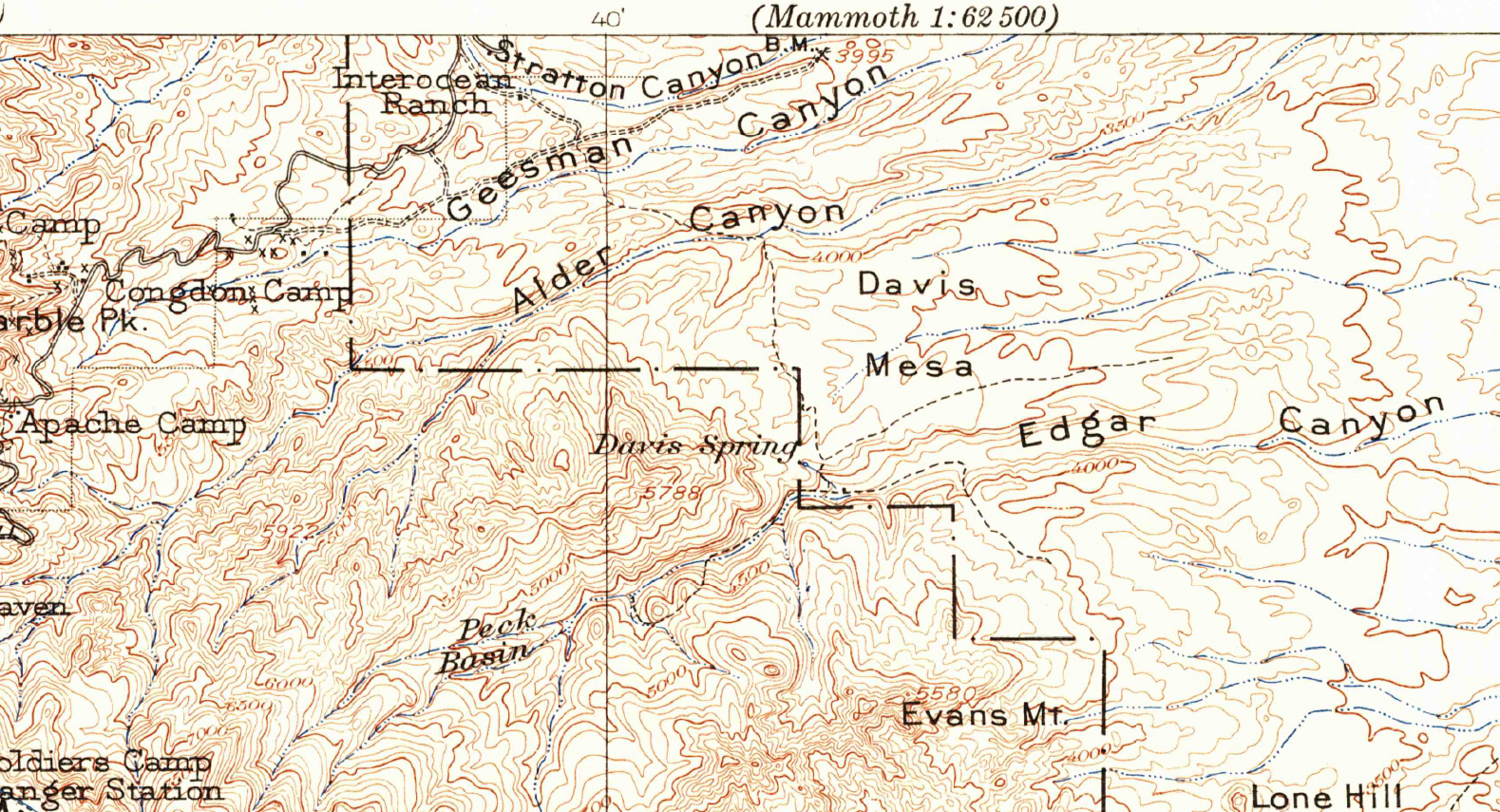
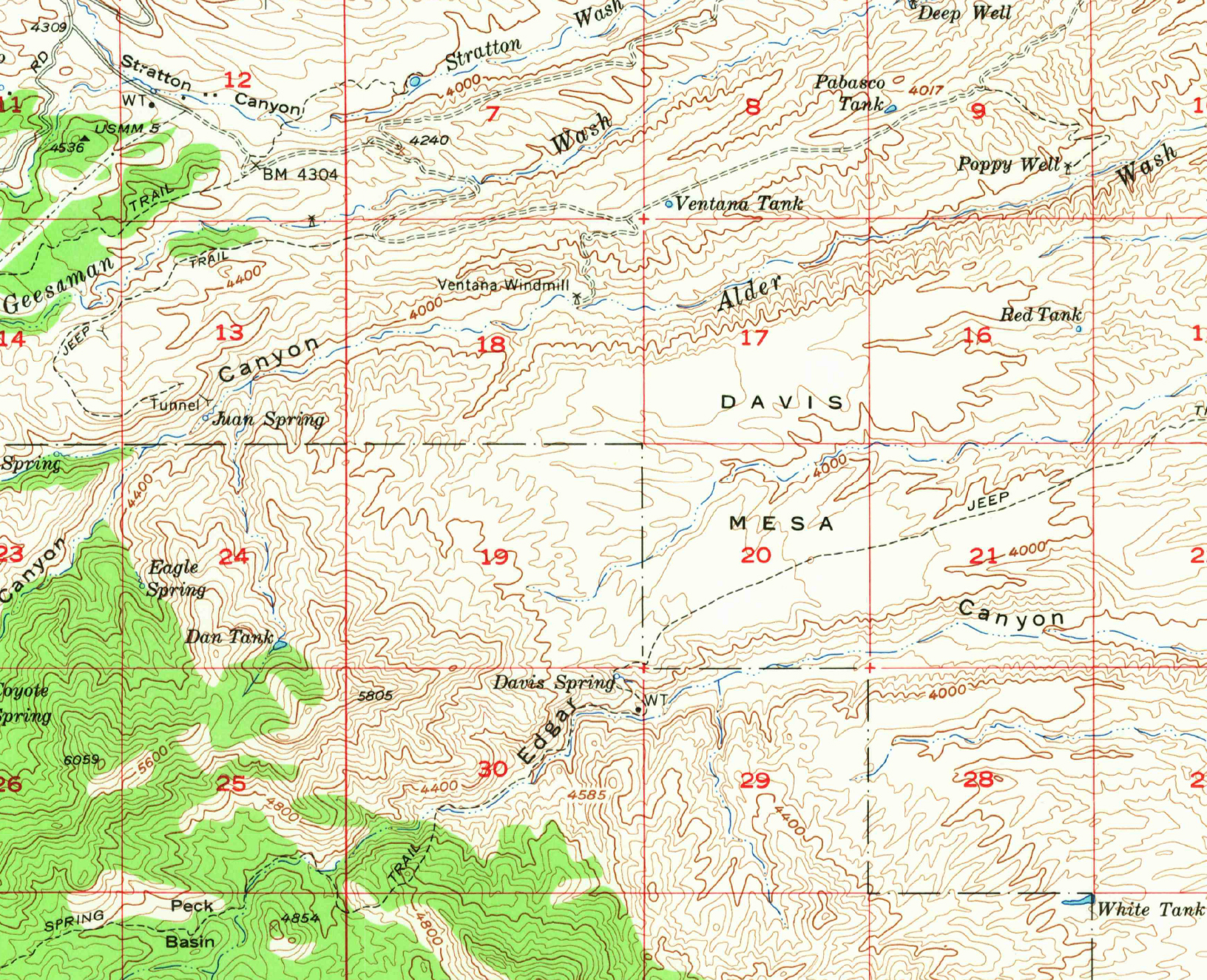
From a 1904 map of the Tucson area – the current Davis Spring Trailhead is near the center of the map above ‘Davis Spring’. Note the trail across Davis Mesa from Alder Canyon… November 2016.
The Davis Spring Trailhead is a gateway into an interesting part of the mountain – but, in addition to the mandatory hour+ drive, the primary access is a long, slow, high-clearance drive from Redington Road – far too few hikers see this area.
North of Edgar Canyon, across Davis Mesa, Black Hills Mine Road runs along the north ridge of Alder Canyon – notably easier to drive than the the Davis Spring Trailhead access road.
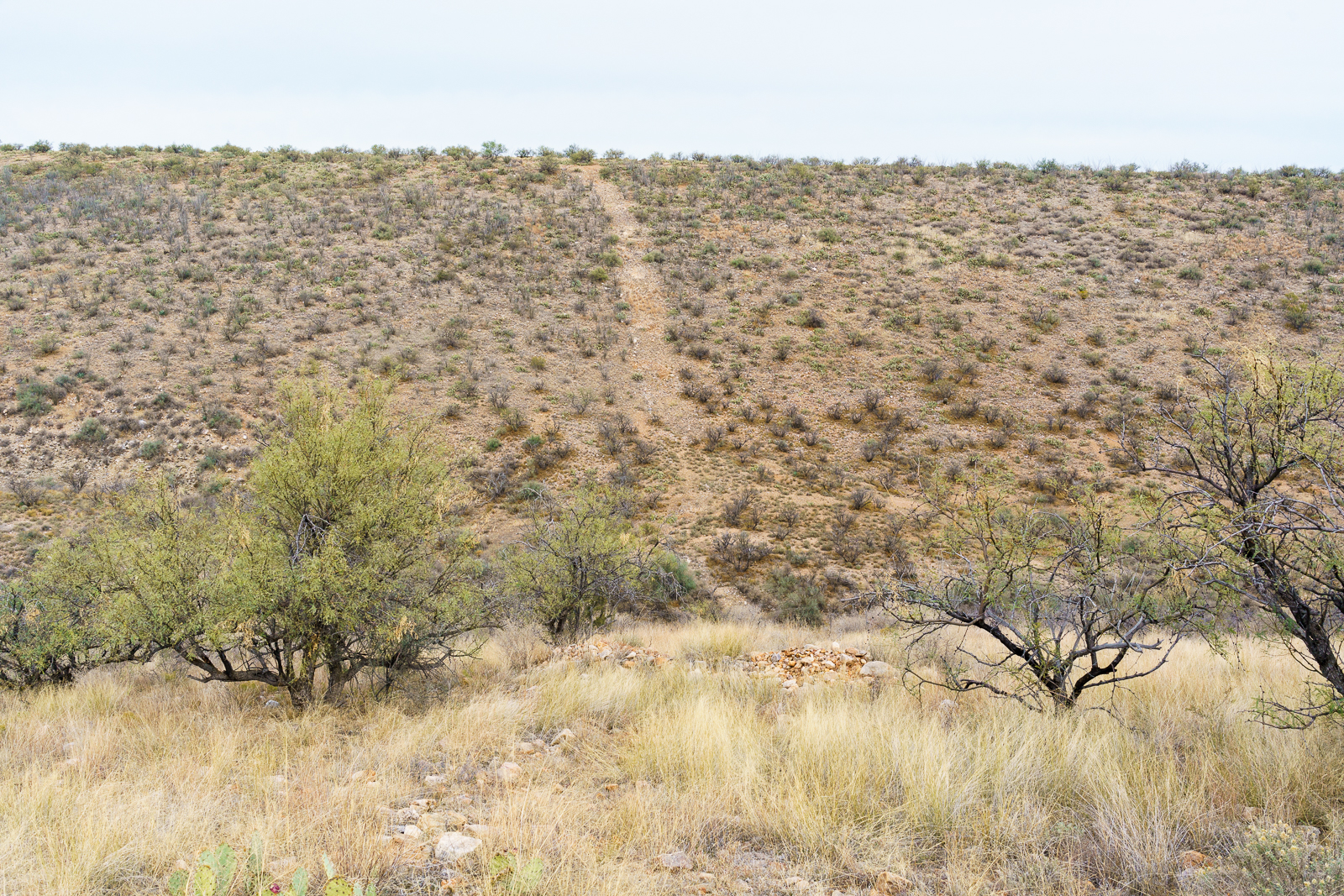
Encouraged by a trail shown on the 1904 USGS Tucson Quadrangle, I wondered if it might be faster to access the Davis Spring Trailhead by parking above Ventana Windmill off Black Hills mine road and hiking across Davis Mesa. I plotted a route across Davis Mesa that, in my living room, seemed like the route would be primarily fast-to-walk easy-to-find double track.
November 2016.
On the south side of Alder Canyon it was clear that the double track, so clear on the aerial views of the area, was not going to be quite as expected – we found hints of it but… I was glad to be hiking with Geoffrey from Trailvoyant – great company and an experienced set of eyes to look for the faint track!
Near the wash splitting Davis Mesa the double track became more distinct, but even then its rocky decent didn’t actually speed us up – on the other side an old road eventually appeared and curved towards the trailhead.
In April of this year this area was covered by a pool of water that was several feet. November 2016.
Clear water flowed from Davis Spring and water is still making its way down to the corral above Edgar Canyon. At the corral we drop into the bottom of the canyon – there is less water than there was in April, and very little flow – mostly just isolated pools.
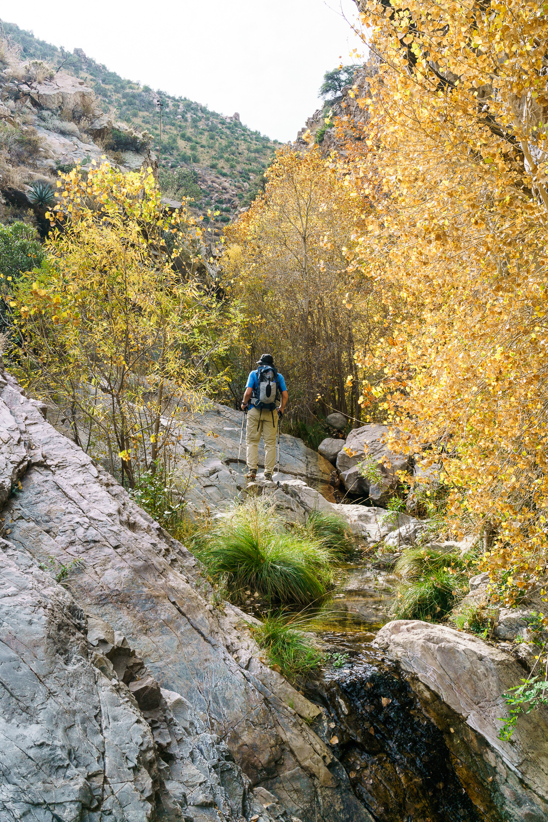
Geoffrey from Trailvoyant enjoying the Fall colors in Edgar Canyon – the Davis Spring Trail bypasses this section of Edgar Canyon on the hillside above. November 2016.
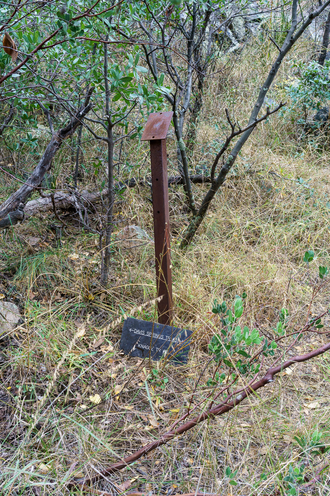
The bottom of the canyon is filled with fall colors – we leave the trail behind as it climbs the canyon side and continue up canyon to the Davis Spring and Knagge Trail junction – our turn around point for the day – on the way back we find, lose, and then find the Davis Spring Trail before crossing back over Davis Mesa and Alder Canyon as the light fades.
Davis Spring Trail and Knagge Trail Junction Sign. November 2016.
On the 1957 Bellota 15′ Map the trail across Davis Mesa is no longer present and our path across Davis Mesa doesn’t seem worth repeating or recommending – a fun adventure and a great day out, but not the alternate Davis Spring Trailhead access I had hoped for!
The 4th edition of the The Santa Catalina Mountains, A Guide to the Trails and Routes added a description of the Alder Canyon Trail (p. 93) with two starting points, Juan Spring and Big Alder Spring – but the lower sections of the canyon are not mentioned. The starting points may might put you in more remote sections of the canyon more quickly – but the section from the Ventana Windmill to Juan Spring is worth noting…
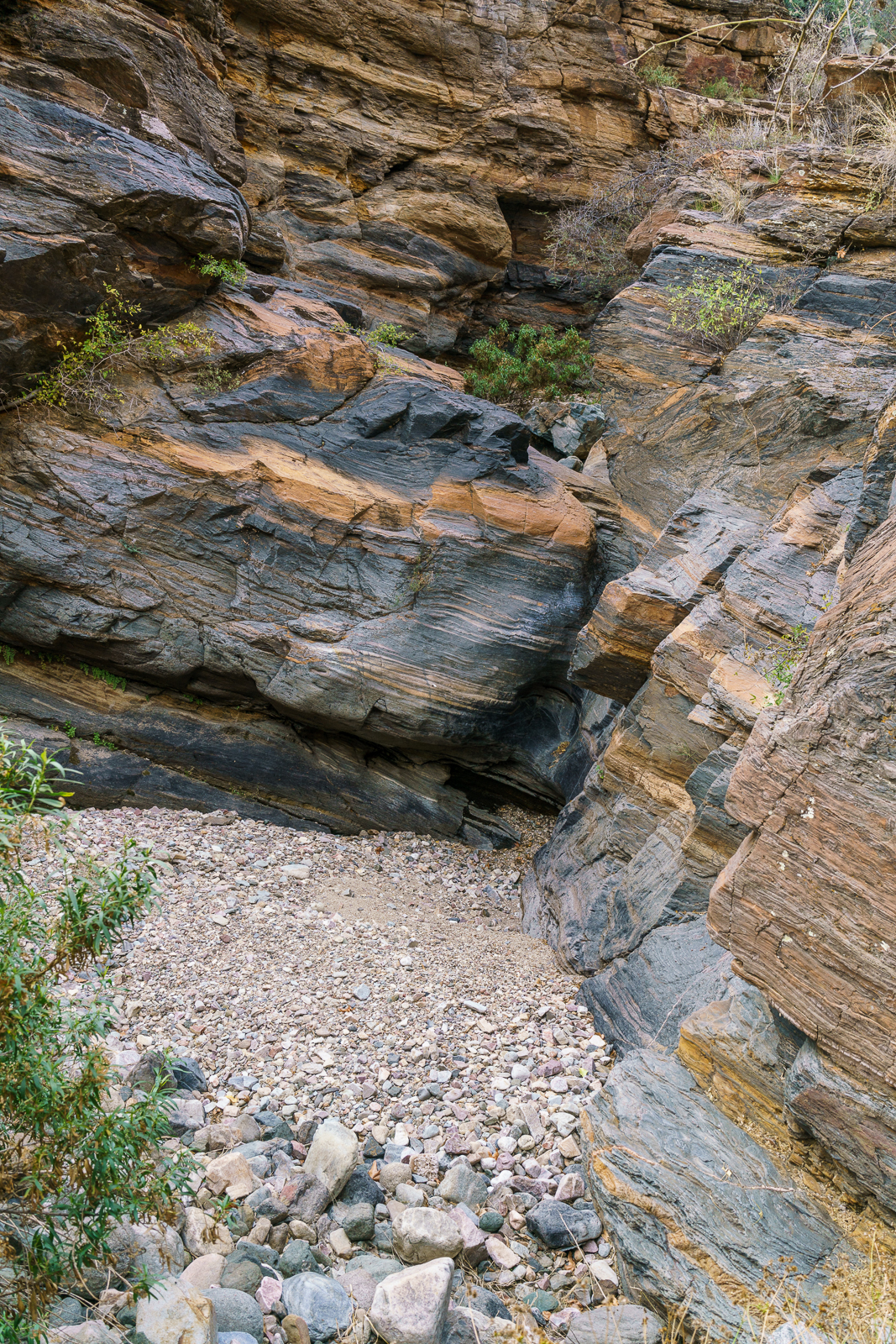
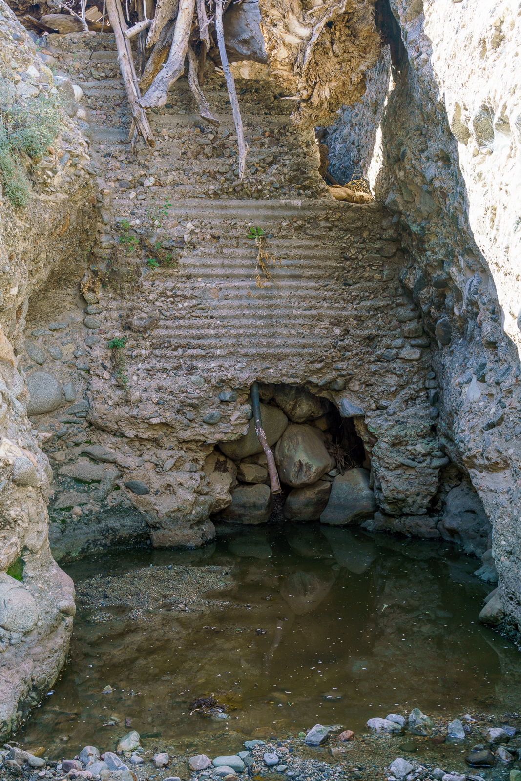
Dam in Alder Canyon above Ventana Windmill. October 2016.
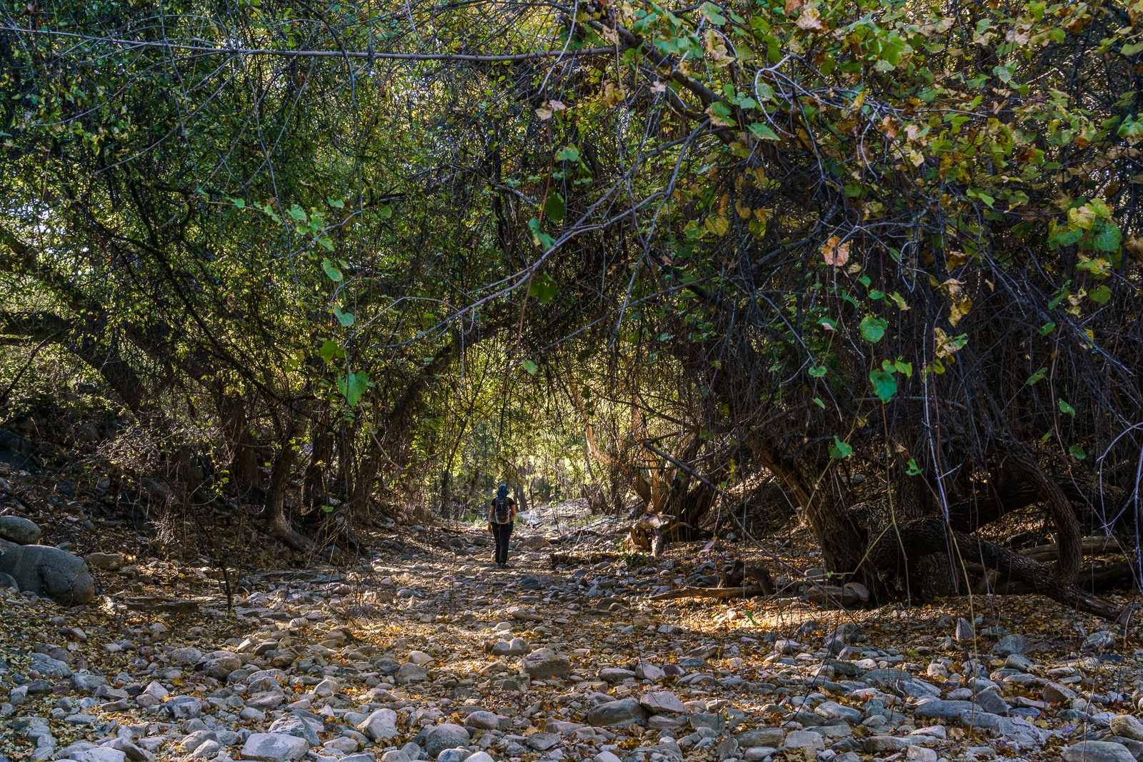
We park off of Black Hills Mine Road, hike down to Ventana Windmill and start hiking up the canyon. In just a few minutes walls of conglomerate close in and an old dam appears – the smell from the pool of water under than dam encourages us to backtrack and walk the cliffs above the narrows.
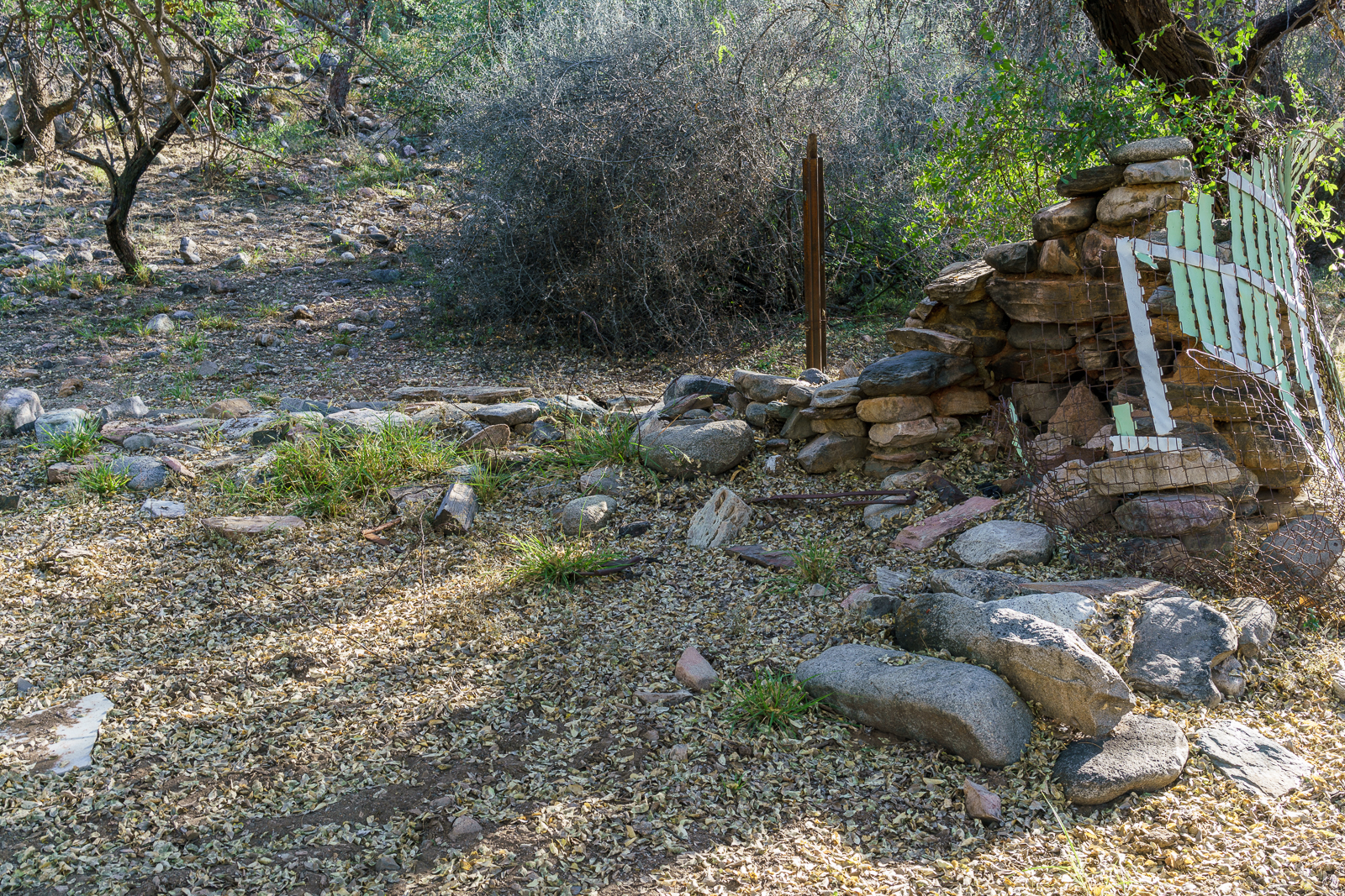
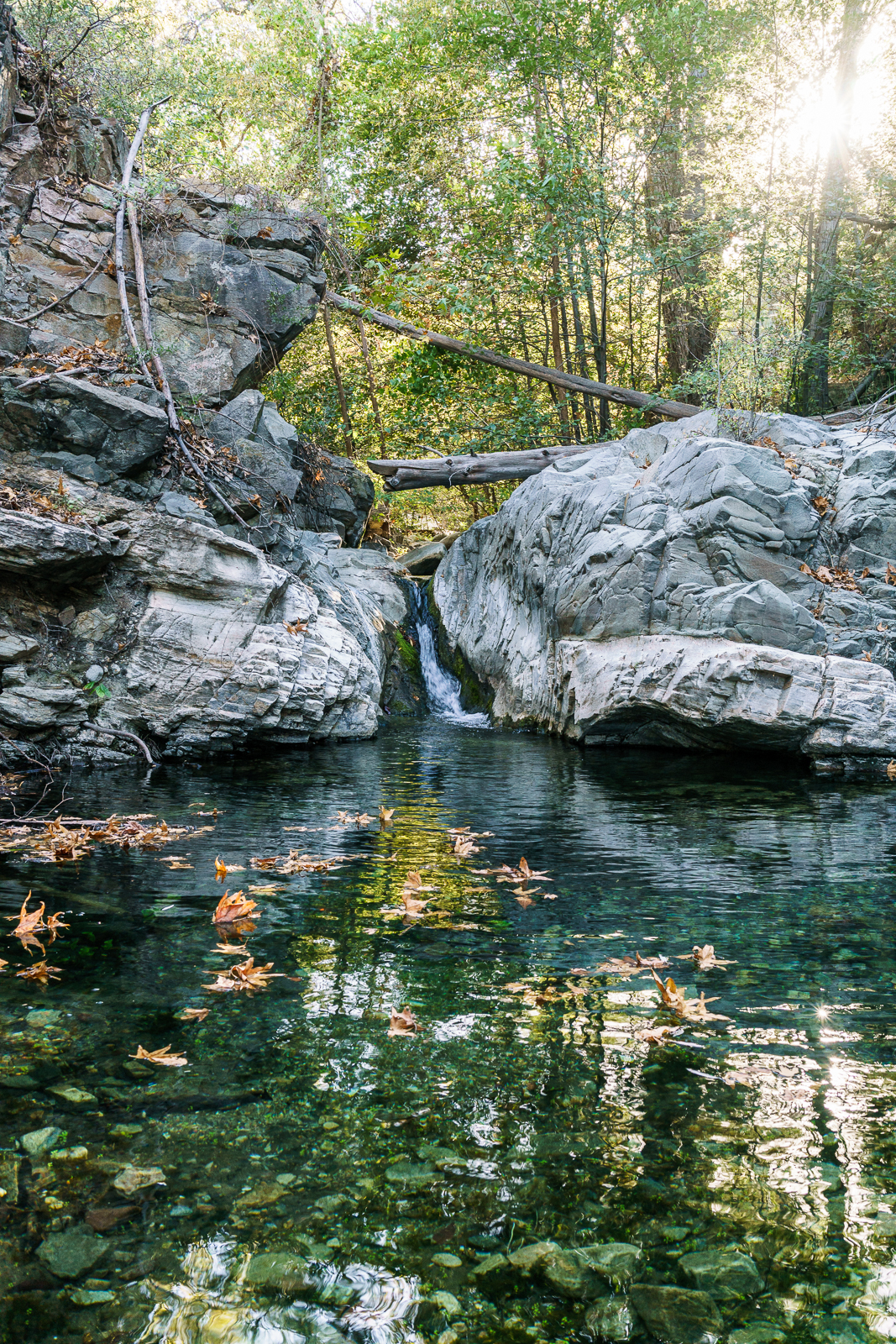
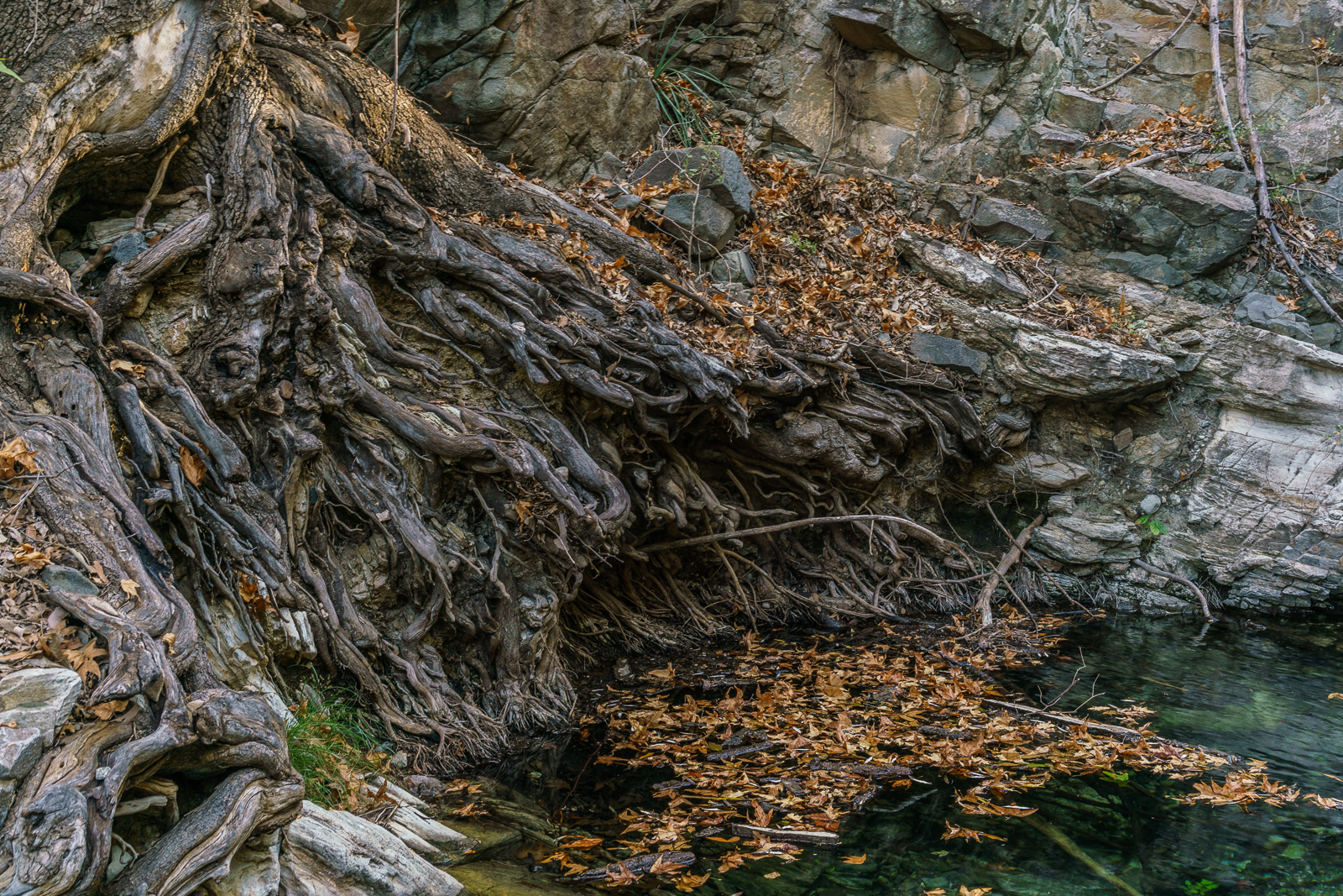
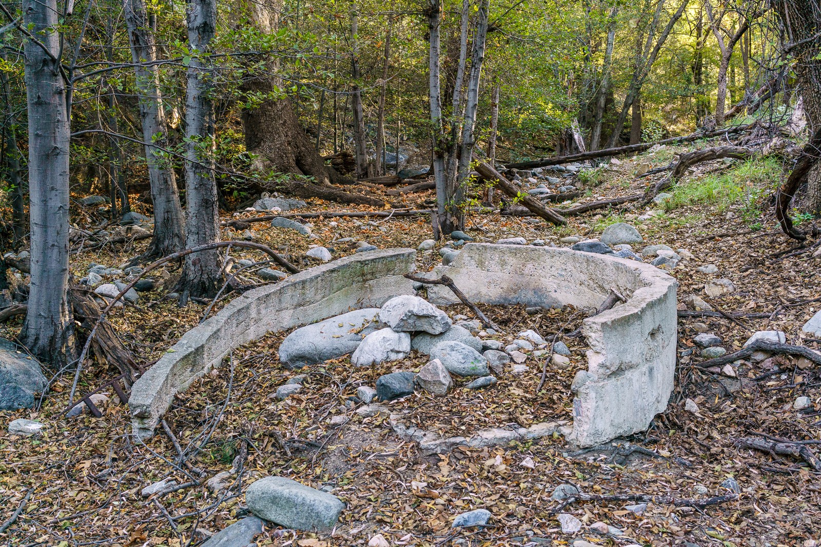
Above the narrows the canyon is beautiful – sometimes more open, sometimes covered by trees – in a particularly lovely spot we find the remains of what might have been a hearth and a small structure. Farther up canyon surface water surprises us – and we are surprised again by clear pools of water. Near Juan Spring we exit the canyon, eventually finding and following the old trail up and loop back to the truck via the road.
An old fireplace and fence near Alder Canyon. October 2016.Inside Alder Canyon. October 2016.Pool in Alder Canyon. October 2016.Roots in Alder Canyon. October 2016.Water trough in Alder Canyon near Juan Spring. October 2016.
A few notes:
On the map a trail is drawn along the canyon from Ventana Windmill to Juan Spring – we spent spent the majority of the hike in the bottom of the canyon, while we didn’t try hard to find the trail I suspect that it is best considered a ‘route’ at this point…
This area is probably used more frequently by hunters than by hikers (AZGF Hunting Seasons, Season Dates, Rules and Regulations – Unit 33) – especially without a commonly used trail in the area it is probably advisable to wear bright colors especially during deer season. (Note that the heaviest users of this area is certainly the cows…)

