


The Guthrie Mountain Trail ends near Point 7281 – the highest peak in the area – but if you look at the USGS 7.5′ maps you might notice that Point 7281 is not labeled ‘Guthrie Mountain’.

However if you look around on the USGS 7.5′ maps for the Santa Catalina Mountains you will eventually find a point well to the south of the ending of the Guthrie Mountain Trail labeled ‘Guthrie Mountain’.
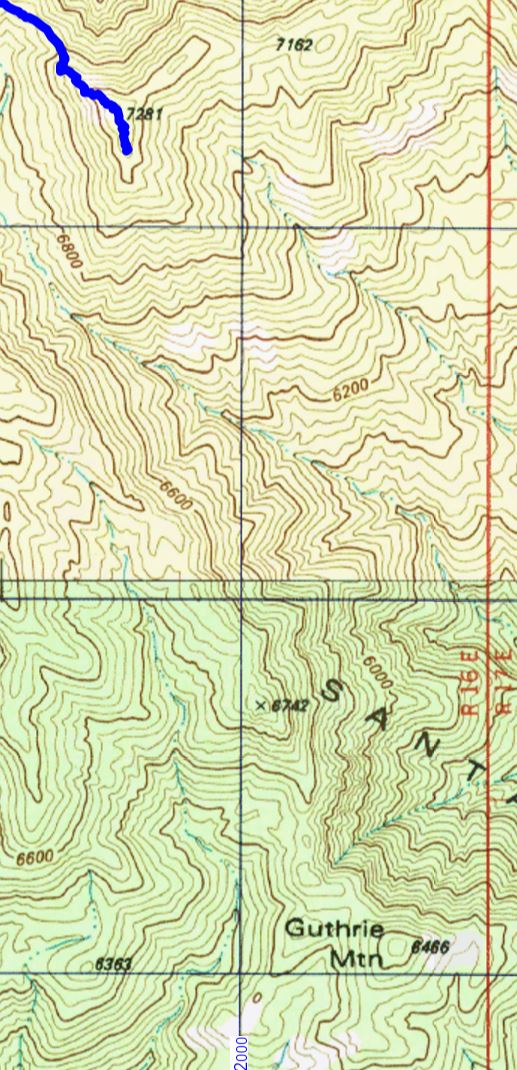
From the 3rd edition of the [GuideYellowBook/], p. 75:
Guthrie Mountain was named for an early forest supervisor in the southwest and is located on the U.S.G.S. quadrangle map as a 6464-foot-high point on the ridge just east of Molino Canyon. It is the opinion of the authors that this is an error and that Guthrie Mountain is the prominent 7300-foot-high point just north of Burro Canyon and about a mile southeast of Bear Saddle.
While I think that the ending point of the Guthrie Mountain Trail makes the most sense as ‘Guthrie Mountain’ the Guthrie Mountain label on the USGS maps provides an excellent excuse to visit another point on the map…
We approached the USGS Guthrie Mountain from the Molino Basin Parking Area, starting on the Bellota Trail but quickly turning onto the route up Molino Canyon. We hiked several miles up the beautifully rugged canyon bottom to a point west of the USGS Guthrie Mountain and, after some debate about what would be the best way up onto the ridge, we began our ascent. What started as a smart/clean way to the ridge quickly devolved into a slow crawl (occasionally literally) thru the Manzanita – thankfully the ridge was fairly close soon we had our first good look at the USGS Guthrie Mountain.

A small trail along the ridge took us quickly to the top – the peak is fairly open on top and there are great views! Not, I think, the ‘real’ Guthrie Mountain – but certainly a beautiful destination.


Views from a loop up the ridge between La Milagrosa and Agua Caliente Canyon and down the La Milagrosa Trail.


The upper section of the Pontatoc Canyon Trail – above the last crossing of Pontatoc Canyon at ~2.1 miles – has been faint/overgrown in some places for years – but the Finger Rock Fire has made it even more obscure.
Not long after the last canyon crossing you enter the burn – not everything is scorched, but the fire was not subtle.
Burned Yuccas lay among flowers and stand in strange and unexpected shapes. Short stretches of the trail are still identifiable – but it would have been difficult to link those sections together without help from occasional cairns. At least for now it seems the upper section of the trail has almost been erased – perhaps in another few seasons the sturdy ‘End of Trail’ sign, still standing in the canyon bottom, will be a puzzling and obscure landmark…


