Setting apart Santa Catalina Forest Reserve, Arizona – 7/2/1902

Statutes At Large Volume 32, 1901 to 1903 - Title Page - this volume, on pages 2012 and 2013, contains the Presidential Proclamation that created the Santa Catalina Forest Reserve. February 2019.
Statutes At Large Volume 32, 1901 to 1903 – Title Page – this volume, on pages 2012 and 2013, contains the Presidential Proclamation that created the Santa Catalina Forest Reserve. February 2019.

The power to establish forest reserves from the public domain was given to the President by the 1891 Forest Reserve Act. Other public lands had been set aside before 1891, but the 1891 provision started an impressive flow of land into Forest Reserves. The first reserve – the Yellowstone Park Timber Land Reserve – was created by President Benjamin Harrison on March 30, 1891, and by the end of his presidency in 1893 he had set aside 13 million acres.

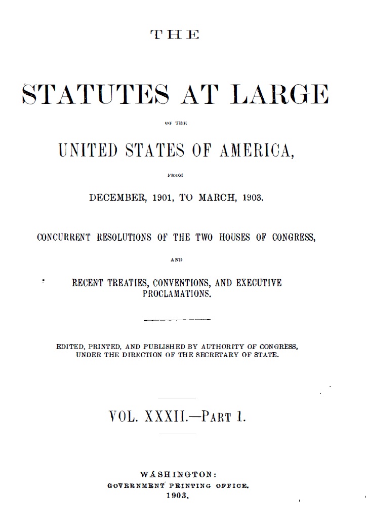
The beginning of the Santa Catalina Mountain’s history as a ‘National Forest’ is recorded in the Statutes at Large of the United States of America from December 1901, to March, 1903, Concurrent Resolutions of the Two Houses of Congress, and Recent Treaties, Conventions, and Executive Proclamations, Volume 32.

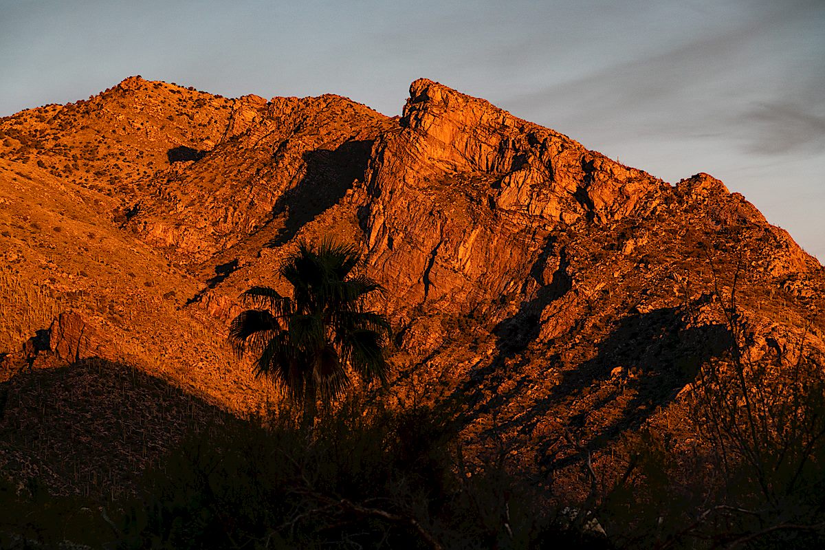
On pages 2012 an 2013, located between proclamations about the Louisiana Purchase Exhibition and the suspension of discriminating duties of tonnage and imposts on Cuban Vessels, Proclamation Number 27 establishes the Santa Catalina Forest Reserve. The 1902 proclamation by Theodore Roosevelt created Santa Catalina Forest Reserve nearly 10 years before Arizona became a state.

Theodore Roosevelt's 1902 Proclamation creating the Santa Catalina Forest Reserve. February 2019.
Theodore Roosevelt’s 1902 Proclamation creating the Santa Catalina Forest Reserve. February 2019.

The first time I tried to look up the proclamation – slightly unsure if I was even in the correct volume – I was temporarily stymied by a typo in the table of content – ‘Setting apart Santa Catilina Forest Reserve, Arizona’ – the typo is not present in the proclamation itself.

Table of Contents from Statutes at Large Volume 32 with a small typo, 'Catilina', the misspelling is not present in the Proclamation. February 2019.
Table of Contents from Statutes at Large Volume 32 with a small typo, ‘Catilina’, the misspelling is not present in the Proclamation. February 2019.

The boundaries of the Santa Catalina National Forest were expanded by a 1907 proclamation by Theodore Roosevelt – now called a National Forest rather than Forest Reserve. The forest was expanded north towards Oracle and south across the Rincons. In 1908 the Santa Catalina National Forest (along with Dragoon and Santa Rita) were absorbed into Coronado National Forest – creating, roughly, the naming and boundaries that are still in existence today.

A map showing the 1907 expansion of the Santa Catalina National Forest. February 2019.
Theodore Roosevelt's 1907 Proclamation expanding the boundaries of the Santa Catalina Mountains. February 2019.
Theodore Roosevelt’s 1907 Proclamation expanding the boundaries of the Santa Catalina Mountains. February 2019.

Forest Road 18 to Radio Ridge, Summer, Winter – MVUM – 5/15/2018, 6/24/2018, 1/14/2019

FR18 - switchbacks and water tanks. May 2018.
FR18 – switchbacks and water tanks. May 2018.

Looking across Carter Canyon from the Mint Spring Trail you can see Forest Road 18 switchbacking up the burned out hillside, past cabins and water tanks, joining and following power lines up to Radio Ridge. It doesn’t have the same appeal as getting up to Radio Ridge on the Aspen or Aspen Draw Trail but summer flowers, winter snow, interesting views… maybe just worth it…

Carter Canyon and Summerhaven from FR18. June 2018.

East of the Mint Spring Trailhead FR18 leaves Carter Canyon Road as Miners Ridge Road – apparently the road was erroneously classified in the Forest Service Infrastructure Database (INFRA) as open to public motor vehicle traffic – corrected in the recently finalized Santa Catalina Ranger District Motorized Travel System where the note for FR18 reads:

In INFRA road is listed as having ML1 and ML2 portions, however, on the ground the road is currently closed to the public, but utilized by authorized personnel. Error in INFRA that restriction to public access not listed. Redesignate in INFRA as “Restricted to Administrative and Permitted Use Only”. ML 2. Radio Ridge access for Mt. Lemmon water district and TRICO Electric. Restricted to reduce intensity of resource impacts.

I don’t recall ever seeing a gate or signage on Miners Ridge Road indicating that it was closed in any way to the public and I assume the note is mainly referencing the top section (the upper section of the road is labeled Radio Ridge Road in Pima County’s GIS Information and Cap Rock Road by Google Maps) where the road has been gated at the Summit Trailhead to prevent public motor vehicle access for as long as I can remember.

FR18 as shown on the maps in the Santa Catalina Ranger District Motorized Travel System NEPA documents. February 2019.
Pygmy Bluet on the side of FR18. June 2018.
Penstemon off FR-18. June 2018.

I’m sure that FR18 is blanketed by snow every year but in previous years it hadn’t occurred to me that the snow covered road would be an interesting hike. This year I was a little smarter – lower on the road there were vehicle tracks, but they eventually disappeared and I plunged into untracked snow up to Radio Ridge – alone for a cold sunset – before making my way down partly by headlamp.

Winter - a snow covered FR-18 with Radio Ridge in the distance. January 2019.
Winter – a snow covered FR-18 with Radio Ridge in the distance. January 2019.
Tree off of Radio Ridge with the Rincons in the background. January 2019.
Snowy Santa Catalina Mountains from near the start of the Aspen Trail off Radio Ridge. January 2019.

Davis Spring Trail – 12/28/2018

Marble Peak from the Davis Mesa Road. December 2018.

Already in Oracle on an errand I made the long drive out to the Davis Spring Trailhead stopping along the way to admire the snow covered peaks in the distance. The road to Davis Mesa seemed to be in about the same condition as previous trips – although the last few miles were muddier than expected. (A 4wd vehicle is recommended for this drive!)

Snow on the Galiuros - Rhodes Peak - from the Davis Mesa Road. December 2018.
Snow on the Galiuros – Rhodes Peak – from the Davis Mesa Road. December 2018.

The long drive didn’t leave much time to hike – past the surprisingly still standing trail sign, flowing water at Davis Spring, a full tank at the corral and down into Edgar Canyon – upstream along the water, downstream in the fallen Sycamore leaves – time to go…

Looking down Edgar Canyon towards Bassett Peak in the Galiuros. December 2018.
Davis Spring - water in the tank in December. December 2018.
Davis Spring – water in the tank in December. December 2018.
Edgar Canyon. December 2018.

Fenced Corridor, Rosewood Point, Campbell Trailhead – 12/22/2018

The fenced access corridor from the Campbell Trailhead. December 2018.

Hiking north from the Campbell Trailhead is an interesting experience – for much of its length the tight corridor to the Pusch Ridge Wilderness is bounded by chain linked fence topped with barbed wire – today it reminds me of a passage from Paul R. Krausman’s And Then There Were None – The Demise of Desert Bighorn Sheep in the Pusch Ridge Wilderness, p. 103:

it was apparent that the growing human population of Tucson and surrounding towns had developed right up to the borders of protected areas, essentially creating an anthropogenic fence around the population of bighorn sheep that prevented them from moving to other mountain ranges that they historically occupied in the Tucson Basin, including the Silver Bell, Tucson, Rincon, and Santa Rita Mountains, which may have provided habitat for a metapopulation of bighorn sheep. This anthropogenic fence clearly added to the genetic isolation of the herd.

I don’t believe there is any intended double meaning in Krausman’s passage – but, in-between the tall chain link, it seems to beg for a re-imagining into the text of a future – strangely similar – volume on a different species:

it was apparent that the growing human population of Tucson and surrounding towns had developed right up to the borders of protected areas, essentially creating an anthropogenic fence that prevented them from moving thru the mountain ranges that they had historically used in the Tucson Basin, including the Silver Bell, Tucson, Rincon, and Santa Rita Mountains, which may have provided critical habitat for escape from their increasingly crowded technologically-dominated urban environment. This anthropogenic fence clearly added to the isolation of the human population from the natural world now so critical to their survival.
Looking across Pima Canyon to Pusch Peak, The Cleaver and Bighorn Mountain from just below Rosewood Point. December 2018.

With an official trailhead you might expect an official trail at the end of the access corridor, but there isn’t one – and with the overlapping concerns of the Pusch Ridge Wilderness and Bighorn Management Area I don’t think there ever will be. Without an official trail entrance into the wilderness is closed at this location from January 1 to April 30 – but the rest of the year you can explore the wilderness – perhaps finding the rough, informal, steep, sometimes obscure and hard to find route that winds its way towards Rosewood Point and up towards more distant destinations.

Looking up Pima Canyon from the Rosewood Point area. December 2018.

Rosewood Point is on the east side of Pima Canyon with views down into the canyon and across to the well known destinations on Pusch Ridge: Pusch Peak, The Cleaver, Bighorn Mountain and Table Mountain – and Rosewood Point is high enough that, like all good destinations in this area of the mountain, there is a thriving population of Shin Daggers to …enjoy… A minor, but worthy, destination.

Sun and fence on the Campbell Trailhead access corridor. December 2018.
Pontatoc Ridge in the Sunset from the Campbell Trailhead. December 2018.

Government Shutdown, Day 24 – 1/14/2019

Bigelow Trailhead - trashed... January 2019.
Bigelow Trailhead – trashed… January 2019.

Trash piles up on Mount Lemmon as government shutdown lingers and endless other headlines from our National Parks during the Government Shutdown are on my mind on the way up the highway.

At Babad Do’ag I don’t see a pile up and at Molino Basin the bathroom doors are open and things look clean – I can see a little trash scattered at Windy Point, but nothing out of the ordinary after a busy weekend and in Bear Canyon things seem fine.

The Bigelow Trailhead is the first place I pull in where the government shutdown really shows – trash is scattered across the parking lot and accumulating under overflowing trash bins – a women hesitates at the bathroom door and turns back to the car exclaiming ‘not fit for a pig’.

Bits of trash at a trailhead really just isn’t all that shocking – there is a reason that I keep a trash picker in the truck – but this amount of trash is unusual and sad. It doesn’t take long to have two trash bags full and leaning against the truck – I’m working on bag three (mostly broken plastic sled pieces) when when a Forest Service Crew pulls up – a sort of trash strike force they quickly empty bins, grab trash and work on the restrooms – in spite of what I suspect must have been an epic (depressing?) day of cleaning up trash they still smile and graciously add my collected garbage to their load.

I wonder if other areas were as bad as the Bigelow Trailhead before the Forest Service crew came thru? Probably… It is sad to see people leave so much trash – and sad that our government can shutdown and leave these places without the care they deserve.

Three Forest Service workers were out cleaning up - barely visible but you they had nearly filled the larger truck and were loading trash into the smaller truck too. January 2019.
Three Forest Service workers were out cleaning up – barely visible but you they had nearly filled the larger truck and were loading trash into the smaller truck too. January 2019.