HikeLemmon

On the Landscape of the Santa Catalina Mountains

Search Tag - peck-basin

|
2012 June Peck Basin
Tags: arizona,butterfly trail,catalina highway scenic area,coronado national forest,peck basin,pima county,santa catalina mountains,santa catalina ranger district
2012 May Looking down into the Peck Basin area
Tags: arizona,catalina highway scenic area,coronado national forest,peck basin,pima county,santa catalina mountains,santa catalina ranger district
2014 April Looking down into the Peck Basin Area from the Butterfly Trail
Tags: arizona,butterfly trail,catalina highway scenic area,coronado national forest,davis spring,edgar canyon,peck basin,pima county,santa catalina mountains,santa catalina ranger district
2014 August Looking down into Peck Basin from the Butterfly Trail
Tags: arizona,butterfly trail,catalina highway scenic area,coronado national forest,peck basin,pima county,san pedro river valley,santa catalina mountains,santa catalina ranger district
2014 December Peck Basin and Davis Mesa from the Butterfly Trail
Tags: arizona,butterfly trail,catalina highway scenic area,coronado national forest,davis mesa,peck basin,pima county,santa catalina mountains,santa catalina ranger district,snow
2014 March Above Araster Spring
Note that in on the USGS Maps this canyon does not have a name - in the Cowgill and Glendening guide this is called Edgar Canyon (which is one drainage south on the USGS Maps).
Tags: araster spring canyon,arizona,butterfly roadless area roadless area,coronado national forest,edgar canyon,peck basin,pima county,santa catalina mountains,santa catalina ranger district
2014 March Araster Spring
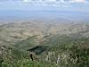
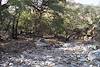
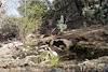
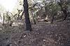
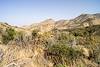
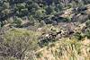
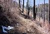
Nearly covered by leaves - there was quite a bit of water and, underneath the leaves, it looked quite clear - certainly used by the cows. Note that in on the USGS Maps this canyon does not have a name - in the Cowgill and Glendening guide this is called Edgar Canyon (which is one drainage south on the USGS Maps).
Tags: araster spring,araster spring canyon,arizona,butterfly roadless area roadless area,coronado national forest,edgar canyon,peck basin,pima county,santa catalina mountains,santa catalina ranger district
2014 March Fence Across and Path Near Araster Spring
There were some beautiful areas near the canyon, but I was surprised the cattle were this area... Note that in on the USGS Maps this canyon does not have a name - in the Cowgill and Glendening guide this is called Edgar Canyon (which is one drainage south on the USGS Maps).
Tags: araster spring canyon,arizona,butterfly roadless area roadless area,coronado national forest,edgar canyon,fence,peck basin,pima county,santa catalina mountains,santa catalina ranger district
2014 March On the hillside above Araster Spring Looking towards Point 5681 and Point 6060
Tags: arizona,butterfly roadless area roadless area,coronado national forest,peck basin,pima county,point,point 4863,point 5681,point 6060,santa catalina mountains,santa catalina ranger district
2014 March The Locals
Not the only cows I saw on this hike... There trails and patties were, seemingly, everywhere.
Tags: arizona,butterfly roadless area roadless area,coronado national forest,cows,peck basin,pima county,santa catalina mountains,santa catalina ranger district
2016 April Climbing up from Araster Spring
Tags: coronado national forest,edgar canyon,peck basin,santa catalina mountains
2016 April Looking over Point 5817 and Across the San Pedro River Valley
Tags: coronado national forest,galiuro mountains,peck basin,point 5817,san pedro river valley,santa catalina mountains,storm
2016 April Point 5817 on the North Ridge of Edgar Canyon
Tags: coronado national forest,peck basin,point 5817,santa catalina mountains
2016 April Ryan in Peck Basin
Tags: coronado national forest,peck basin,ryan,santa catalina mountains
2016 September Looking Down into the Peck Basin area from Green Mountain
Tags: coronado national forest,edgar canyon,green mountain,peck basin,point 5810,point 5817,point 6053,san pedro river,san pedro river valley,santa catalina mountains
2017 May Looking Down into Peck Basin and Edgar Canyon
Tags: butterfly trail,coronado national forest,edgar canyon,evans mountain,peck basin,point 5810,point 5817,santa catalina mountains
2014 April A last Bit of Snow near the Butterfly Trail
Tags: butterfly trail,coronado national forest,mount bigelow,peck basin,santa catalina mountains,snow
2016 September Guthrie Mountain from Green Mountain
Views from Green Mountain.
Tags: agua caliente hill,airmen peak,coronado national forest,green mountain,guthrie mountain,mica mountain,peck basin,rincon peak,san pedro vista,santa catalina mountains